 |
|
| Gallatin Field Airport |
 |
| IATA: BZN – ICAO: KBZN – FAA LID: BZN |
| Summary |
| Airport type |
Public |
| Operator |
Gallatin Airport Authority |
| Serves |
Bozeman, Montana |
| Location |
Belgrade, Montana |
| Elevation AMSL |
4,471 ft / 1,363 m |
| Coordinates |
45°46′39″N 111°09′11″W / 45.7775°N 111.15306°W / 45.7775; -111.15306 |
| Website |
www.bozemanairport.com |
| Runways |
| Direction |
Length |
Surface |
| ft |
m |
| 12/30 |
9,003 |
2,744 |
Asphalt |
| 11/29 |
3,197 |
974 |
Turf |
| 3/21 |
2,650 |
808 |
Asphalt |
| Statistics (2007) |
| Aircraft operations |
81,010 |
| Based aircraft |
275 |
| Source: FAA and airport web site |
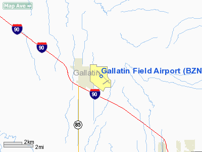
Gallatin Field Airport (IATA: BZN, ICAO: KBZN, FAA LID: BZN), also known as Gallatin Field, is a public-use airport located seven nautical miles (13 km) northwest of the central business district of Bozeman, a city in Gallatin County, Montana, United States. It is owned by the Gallatin Airport Authority. The airport is situated in Belgrade, Montana and serves Bozeman, Big Sky, Southwestern Montana and Yellowstone National Park. Facilities and aircraft
Gallatin Field covers an area of 2,481 acres (1,004 ha) at an elevation of 4,471 feet (1,363 m) above mean sea level. It has three runways: 12/30 has a 9,003 by 150 ft (2,744 x 46 m) asphalt surface; 11/29 has a 3,197 by 80 ft (974 x 24 m) turf surface; and 3/21 has a 2,650 by 75 ft (808 x 23 m) asphalt surface.
For the 12-month period ending April 30, 2007, the airport had 81,010 aircraft operations, an average of 221 per day: 77% general aviation, 13% air taxi, 9% scheduled commercial and <1% military. At that time there were 275 aircraft based at this airport: 75% single-engine, 6% multi-engine, 10% jet, 3% helicopter and 6% glider.
Airlines and destinations
| Airlines |
Destinations |
| Allegiant Air |
Las Vegas, Phoenix-Mesa [begins November 12] |
| Delta Air Lines |
Atlanta, Detroit, Minneapolis/St. Paul [all seasonal] |
| Delta Connection operated by Compass Airlines |
Minneapolis/St. Paul |
| Delta Connection operated by SkyWest Airlines |
Salt Lake City |
| Frontier Airlines operated by Republic Airlines |
Denver |
| Horizon Air |
Seattle/Tacoma |
| United Airlines |
Chicago-O’Hare, Denver [both seasonal] |
| United Express operated by SkyWest Airlines |
Chicago-O’Hare, Denver, Los Angeles [seasonal], San Francisco [seasonal] |
The above content comes from Wikipedia and is published under free licenses – click here to read more.
Location & QuickFacts
| FAA Information Effective: | 2008-09-25 |
| Airport Identifier: | BZN |
| Airport Status: | Operational |
| Longitude/Latitude: | 111-09-10.7270W/45-46-38.8690N
-111.152980/45.777464 (Estimated) |
| Elevation: | 4471 ft / 1362.76 m (Surveyed) |
| Land: | 2481 acres |
| From nearest city: | 7 nautical miles NW of Bozeman, MT |
| Location: | Gallatin County, MT |
| Magnetic Variation: | 18E (1965) |
Owner & Manager
| Ownership: | Publicly owned |
| Owner: | Gallatin Airport Authority |
| Address: | 850 Gallatin Field Suite 6
Belgrade, MT 59714 |
| Phone number: | 406-388-6632 |
| Manager: | Ted Mathis |
| Address: | 850 Gallatin Field Rd, Suite #6
Belgrade, MT 59714 |
| Phone number: | 406-388-6632 |
Airport Operations and Facilities
| Airport Use: | Open to public |
| Wind indicator: | Yes |
| Segmented Circle: | No |
| Control Tower: | Yes |
| Lighting Schedule: | DUSK-DAWN
WHEN ATCT CLSD ACTVT HIRL RY 12/30 AND MALSR RY 12 - CTAF. AT ALL TIMES ACTVT REIL RY 30 - CTAF. |
| Beacon Color: | Clear-Green (lighted land airport) |
| Landing fee charge: | Yes
LNDG FEE FOR ACFT OVER 12500 LBS. |
| Sectional chart: | Great Falls |
| Region: | ANM - Northwest Mountain |
| Boundary ARTCC: | ZLC - Salt Lake City |
| Tie-in FSS: | GTF - Great Falls |
| FSS on Airport: | No |
| FSS Toll Free: | 1-800-WX-BRIEF |
| NOTAMs Facility: | BZN (NOTAM-d service avaliable) |
| Certification type/date: | I B S 05/1973 |
| Federal Agreements: | NGY3 |
Airport Communications
| CTAF: | 118.200 |
| Unicom: | 122.950 |
Airport Services
| Fuel available: | 100 100LLA |
| Airframe Repair: | MAJOR |
| Power Plant Repair: | MAJOR |
| Bottled Oxygen: | HIGH/LOW |
| Bulk Oxygen: | HIGH/LOW |
Runway Information
Runway 03/21
| Dimension: | 2650 x 75 ft / 807.7 x 22.9 m |
| Surface: | ASPH, Good Condition |
| Weight Limit: | Single wheel: 26000 lbs.
FOR DC-10-40 650000 AND FOR B747-100 770000. |
| |
Runway 03 |
Runway 21 |
| Longitude: | 111-09-09.3073W | 111-08-42.5290W |
| Latitude: | 45-46-07.8886N | 45-46-26.1390N |
| Elevation: | 4471.00 ft | 4451.00 ft |
| Alignment: | 46 | 127 |
| Traffic Pattern: | Left | Left |
| Markings: | Basic, Good Condition | Basic, Good Condition |
|
Runway 11/29
| Dimension: | 3197 x 80 ft / 974.4 x 24.4 m |
| Surface: | TURF, Good Condition |
| |
Runway 11 |
Runway 29 |
| Longitude: | 111-09-10.6200W | 111-08-39.1100W |
| Latitude: | 45-46-51.9900N | 45-46-29.4000N |
| Elevation: | 4440.00 ft | 4453.00 ft |
| Alignment: | 127 | 127 |
| Traffic Pattern: | Left | Left |
|
Runway 12/30
| Dimension: | 9003 x 150 ft / 2744.1 x 45.7 m |
| Surface: | ASPH, Good Condition |
| Surface Treatment: | Saw-cut or plastic Grooved |
| Weight Limit: | Single wheel: 75000 lbs.
Dual wheel: 175000 lbs.
Dual tandem wheel: 280000 lbs.
FOR DC-10-40 650000 AND FOR B747-100 770000. |
| Edge Lights: | High |
| |
Runway 12 |
Runway 30 |
| Longitude: | 111-09-59.3840W | 111-08-30.7880W |
| Latitude: | 45-47-17.1340N | 45-46-13.4720N |
| Elevation: | 4421.00 ft | 4458.00 ft |
| Alignment: | 127 | 127 |
| ILS Type: | ILS
| |
| Traffic Pattern: | Left | Left |
| Markings: | Precision instrument, Good Condition | Precision instrument, Good Condition |
| Crossing Height: | 55.00 ft | 51.00 ft |
| VASI: | 4-box on left side | 4-box on left side |
| Visual Glide Angle: | 3.00° | 3.00° |
| Approach lights: | MALSR | |
| Runway End Identifier: | | Yes |
|
Radio Navigation Aids
| ID |
Type |
Name |
Ch |
Freq |
Var |
Dist |
| EKS | NDB | Ennis | | 286.00 | 15E | 37.2 nm |
| BZN | VOR/DME | Bozeman | 071X | 112.40 | 18E | 0.4 nm |
| LVM | VORTAC | Livingston | 108X | 116.10 | 15E | 30.1 nm |
| HIA | VORTAC | Whitehall | 084X | 113.70 | 18E | 42.9 nm |
Remarks
- NORMAL SNOW REMOVAL UNAVBL 2300-0600.
- TKOF RWY 3 PROHIBITED UNTIL AFTER CFMG NO TFC USING RWY 12.
- SNOW REMOVAL EQUIP MONITORS - CTAF.
- GLIDER OPNS ON & INVOF ARPT.
- RY 21 BTN RY 12/30 & TWY A AVBL FOR AIR CARRIER USE DAY/VFR ONLY.
- MIGRATORY BIRDS INVOF ARPT.
Images and information placed above are from
http://www.airport-data.com/airport/BZN/
We thank them for the data!
| General Info
|
| State |
MONTANA
|
| FAA ID |
BZN
|
| Latitude |
45-46-36.845N
|
| Longitude |
111-09-10.826W
|
| Elevation |
4474 feet
|
| Near City |
BOZEMAN
|
We don't guarantee the information is fresh and accurate. The data may
be wrong or outdated.
For more up-to-date information please refer to other sources.
|
|


