 |
|
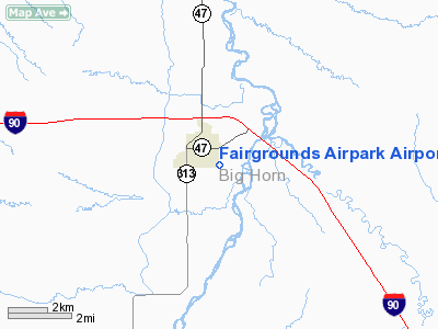
Fairgrounds Airpark Airport |
Location & QuickFacts
| FAA Information Effective: | 2008-09-25 |
| Airport Identifier: | F02 |
| Airport Status: | Operational |
| Longitude/Latitude: | 107-36-02.3110W/45-43-29.9190N
-107.600642/45.724978 (Estimated) |
| Elevation: | 2911 ft / 887.27 m (Surveyed) |
| Land: | 64 acres |
| From nearest city: | 1 nautical miles SE of Hardin, MT |
| Location: | Big Horn County, MT |
| Magnetic Variation: | 14E (1985) |
Owner & Manager
| Ownership: | Publicly owned |
| Owner: | County Of Big Horn |
| Address: | County Courthouse
Hardin, MT 59034 |
| Phone number: | 406-665-3520 |
| Manager: | Larry Romine |
| Address: | Po Box 387
Hardin, MT 59034 |
| Phone number: | 406-670-1403 |
Airport Operations and Facilities
| Airport Use: | Open to public |
| Wind indicator: | Yes |
| Segmented Circle: | No |
| Control Tower: | No |
| Lighting Schedule: | DUSK-DAWN |
| Beacon Color: | Clear-Green (lighted land airport)
ROTG BCN OTS INDEFLY. |
| Landing fee charge: | No |
| Sectional chart: | Billings |
| Region: | ANM - Northwest Mountain |
| Boundary ARTCC: | ZLC - Salt Lake City |
| Tie-in FSS: | GTF - Great Falls |
| FSS on Airport: | No |
| FSS Toll Free: | 1-800-WX-BRIEF |
| NOTAMs Facility: | GTF (NOTAM-d service avaliable) |
Airport Communications
| CTAF: | 122.800 |
| Unicom: | 122.800 |
Airport Services
| Airframe Repair: | MINOR |
| Power Plant Repair: | MINOR |
| Bottled Oxygen: | NONE |
| Bulk Oxygen: | NONE |
Runway Information
Runway 04/22
| Dimension: | 3542 x 60 ft / 1079.6 x 18.3 m |
| Surface: | ASPH, Fair Condition
RWY 04/22 LARGE CRACKS WITH WEEDS GROWING THROUGH SURFACE AND ENCROACHING BORDERS. |
| Weight Limit: | Single wheel: 15000 lbs.
Dual wheel: 23000 lbs. |
| Edge Lights: | Non-standard lighting system
RY 04/22 NSTD LIRL THLD LGTS 6 FT FORWARD OF MKD THLD AND SPACED 4 FT APART STARTING 5 FT FM RY EDGE. |
| |
Runway 04 |
Runway 22 |
| Traffic Pattern: | Left | Left |
| Markings: | Basic, Fair Condition | Basic, Fair Condition |
| Displaced threshold: | 224.00 ft
DSPLCD THLDS MKD BUT NOT LGTD, THLD DSPLCD FOR DAY OPNS ONLY. | 168.00 ft |
| Obstruction: | 51 ft tree, 840.0 ft from runway, 93 ft right of centerline, 12:1 slope to clear
RY 04 APCH SLOPE 20:1 FM DSPLCD THLD.
+3 FT FENCE & -5 FT DITCH 150 FT FM EOR; 12-15 FT BRUSH & TREES 97 FT L OF CNTRLN 100 FT FM EOR TO 140 FT FM EOR. | 26 ft ant, 429.0 ft from runway, 38 ft right of centerline, 8:1 slope to clear
RWY 22 APCH SLOPE 22:1 FM DSPLCD THLD.
12 FT HANGARS 70 FT R OF CNTRLN IN PRIMARY SFC. |
|
Radio Navigation Aids
| ID |
Type |
Name |
Ch |
Freq |
Var |
Dist |
| BIL | VORTAC | Billings | 092X | 114.50 | 14E | 43.2 nm |
Remarks
- RY 04/22 LGTD GRAIN ELEVATOR & GRAIN STORAGE BINS IN TRANSITIONAL SFC.
- ESTABLISHED PRIOR TO 1959.
Images and information placed above are from
http://www.airport-data.com/airport/F02/
We thank them for the data!
| General Info
|
| Country |
United States
|
| State |
MONTANA
|
| FAA ID |
F02
|
| Latitude |
45-43-29.919N
|
| Longitude |
107-36-02.311W
|
| Elevation |
2911 feet
|
| Near City |
HARDIN
|
We don't guarantee the information is fresh and accurate. The data may
be wrong or outdated.
For more up-to-date information please refer to other sources.
|
|


