 |
|
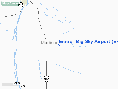
Location & QuickFacts
| FAA Information Effective: | 2008-09-25 |
| Airport Identifier: | EKS |
| Airport Status: | Operational |
| Longitude/Latitude: | 111-38-55.1000W/45-16-18.3300N
-111.648639/45.271758 (Estimated) |
| Elevation: | 5387 ft / 1641.96 m (Surveyed) |
| Land: | 200 acres |
| From nearest city: | 6 nautical miles SE of Ennis, MT |
| Location: | Madison County, MT |
| Magnetic Variation: | 16E (1985) |
Owner & Manager
| Ownership: | Publicly owned |
| Owner: | Madison County |
| Address: | County Courthouse
Virginia City, MT 59755 |
| Phone number: | 406-843-4230 |
| Manager: | Bob Gates |
| Address: | Po Box 865
Ennis, MT 59729 |
| Phone number: | 406-682-4297
OR (406) 682-7502 |
Airport Operations and Facilities
| Airport Use: | Open to public |
| Wind indicator: | Yes |
| Segmented Circle: | Yes |
| Control Tower: | No |
| Lighting Schedule: | DUSK
ROTG BCN OPERATE DUSK +2 HRS; OTHER TIMES, ACTVT - CTAF. |
| Beacon Color: | Clear-Green (lighted land airport) |
| Landing fee charge: | No |
| Sectional chart: | Great Falls |
| Region: | ANM - Northwest Mountain |
| Boundary ARTCC: | ZLC - Salt Lake City |
| Tie-in FSS: | GTF - Great Falls |
| FSS on Airport: | No |
| FSS Toll Free: | 1-800-WX-BRIEF |
| NOTAMs Facility: | GTF (NOTAM-d service avaliable) |
| Federal Agreements: | N |
Airport Communications
| CTAF: | 122.800 |
| Unicom: | 122.800 |
Airport Services
| Fuel available: | 100 A
FOR JET A FUEL AFTER HRS CALL 406-682-4297. |
| Airframe Repair: | MINOR |
| Power Plant Repair: | MINOR |
Runway Information
Runway 16/34
| Dimension: | 4700 x 75 ft / 1432.6 x 22.9 m |
| Surface: | ASPH, Fair Condition |
| Weight Limit: | Single wheel: 12500 lbs. |
| Edge Lights: | Medium |
| |
Runway 16 |
Runway 34 |
| Longitude: | 111-38-57.0520W | 111-38-53.1680W |
| Latitude: | 45-16-41.4570N | 45-15-55.1460N |
| Elevation: | 5387.00 ft | 5349.00 ft |
| Alignment: | 127 | 127 |
| Traffic Pattern: | Right | Left |
| Markings: | Basic, Fair Condition
16/34 1000 FT FIXED DISTANCE MARKERS EACH END. | Basic, Fair Condition |
| Crossing Height: | 33.00 ft | 37.00 ft |
| VASI: | 2-light PAPI on left side | 2-light PAPI on left side |
| Visual Glide Angle: | 3.00° | 3.00° |
| Obstruction: | 7 ft fence, 393.0 ft from runway, 27:1 slope to clear | , 50:1 slope to clear |
|
Radio Navigation Aids
| ID |
Type |
Name |
Ch |
Freq |
Var |
Dist |
| EKS | NDB | Ennis | | 286.00 | 15E | 0.4 nm |
| ESY | NDB | Yellowstone | | 338.00 | 17E | 41.6 nm |
| LO | NDB | Targy | | 415.00 | 16E | 46.0 nm |
| BZN | VOR/DME | Bozeman | 071X | 112.40 | 18E | 37.1 nm |
| DLN | VOR/DME | Dillon | 077X | 113.00 | 18E | 38.0 nm |
| HIA | VORTAC | Whitehall | 084X | 113.70 | 18E | 41.7 nm |
Images and information placed above are from
http://www.airport-data.com/airport/EKS/
We thank them for the data!
| General Info
|
| Country |
United States
|
| State |
MONTANA
|
| FAA ID |
EKS
|
| Latitude |
45-16-18.330N
|
| Longitude |
111-38-55.100W
|
| Elevation |
5383 feet
|
| Near City |
ENNIS
|
We don't guarantee the information is fresh and accurate. The data may
be wrong or outdated.
For more up-to-date information please refer to other sources.
|
|


