 |
|
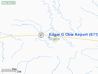
Location & QuickFacts
| FAA Information Effective: | 2008-09-25 |
| Airport Identifier: | S71 |
| Airport Status: | Operational |
| Longitude/Latitude: | 109-15-02.2000W/48-35-31.6000N
-109.250611/48.592111 (Estimated) |
| Elevation: | 2416 ft / 736.40 m (Surveyed) |
| Land: | 172 acres |
| From nearest city: | 1 nautical miles W of Chinook, MT |
| Location: | Blaine County, MT |
| Magnetic Variation: | 16E (1985) |
Owner & Manager
| Ownership: | Publicly owned |
| Owner: | Blaine Co-city Of Chinook |
| Address: | County Courthouse,
Chinook, MT 59523 |
| Phone number: | 406-357-3250 |
| Manager: | Edgar Obie Jr. |
| Address: | Po Box 7
Chinook, MT 59523 |
| Phone number: | 406-357-2429 |
Airport Operations and Facilities
| Airport Use: | Open to public |
| Wind indicator: | Yes |
| Segmented Circle: | Yes |
| Control Tower: | No |
| Lighting Schedule: | DUSK-DAWN
ACTVT PAPI RY 26 - CTAF. ACTVT MIRL RY 08-26 DAWN-DUSK - CTAF. AFTER DUSK MIRL ON CONTINUOUSLY UNTIL DAWN. |
| Beacon Color: | Clear-Green (lighted land airport) |
| Landing fee charge: | No |
| Sectional chart: | Great Falls |
| Region: | ANM - Northwest Mountain |
| Traffic Pattern Alt: | 800 ft |
| Boundary ARTCC: | ZLC - Salt Lake City |
| Tie-in FSS: | GTF - Great Falls |
| FSS on Airport: | No |
| FSS Toll Free: | 1-800-WX-BRIEF |
| NOTAMs Facility: | GTF (NOTAM-d service avaliable) |
| Federal Agreements: | NGY |
Airport Communications
| CTAF: | 122.800 |
| Unicom: | 122.800 |
Airport Services
| Fuel available: | 100LL |
| Airframe Repair: | MINOR |
| Power Plant Repair: | MINOR |
| Bottled Oxygen: | NONE |
| Bulk Oxygen: | NONE |
Runway Information
Runway 08/26
| Dimension: | 4000 x 75 ft / 1219.2 x 22.9 m |
| Surface: | ASPH, Good Condition |
| Weight Limit: | Single wheel: 12500 lbs. |
| Edge Lights: | Medium |
| |
Runway 08 |
Runway 26 |
| Longitude: | 109-15-31.4900W | 109-14-32.9100W |
| Latitude: | 48-35-35.0500N | 48-35-28.1500N |
| Elevation: | 2416.00 ft | 2409.00 ft |
| Alignment: | 100 | 127 |
| Traffic Pattern: | Left | Left |
| Markings: | Basic, Good Condition | Basic, Good Condition |
| Crossing Height: | 0.00 ft | 37.00 ft |
| VASI: | | 2-light PAPI on left side |
| Visual Glide Angle: | 0.00° | 4.00° |
|
Radio Navigation Aids
| ID |
Type |
Name |
Ch |
Freq |
Var |
Dist |
| LDS | NDB | Leeds | | 389.00 | 16E | 17.7 nm |
| HVR | VOR/DME | Havre | 055X | 111.80 | 16E | 20.9 nm |
Remarks
- EXISTED PRIOR TO 05/15/59.
Images and information placed above are from
http://www.airport-data.com/airport/S71/
We thank them for the data!
| General Info
|
| Country |
United States
|
| State |
MONTANA
|
| FAA ID |
S71
|
| Latitude |
48-35-31.000N
|
| Longitude |
109-14-56.000W
|
| Elevation |
2413 feet
|
| Near City |
CHINOOK
|
We don't guarantee the information is fresh and accurate. The data may
be wrong or outdated.
For more up-to-date information please refer to other sources.
|
|


