 |
|
| Dillon Airport |
| IATA: DLN – ICAO: KDLN – FAA LID: DLN |
| Summary |
| Airport type |
Public |
| Owner |
Beaverhead County |
| Serves |
Dillon, Montana |
| Elevation AMSL |
5,241 ft / 1,597 m |
| Coordinates |
45°15′19″N 112°33′09″W / 45.25528°N 112.5525°W / 45.25528; -112.5525 |
| Runways |
| Direction |
Length |
Surface |
| ft |
m |
| 16/34 |
6,500 |
1,981 |
Asphalt |
| 3/21 |
3,599 |
1,097 |
Asphalt |
| Statistics (2008) |
| Aircraft operations |
10,500 |
| Based aircraft |
21 |
| Source: Federal Aviation Administration |
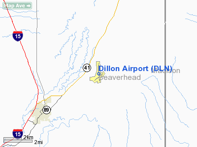
Dillon Airport (IATA: DLN, ICAO: KDLN, FAA LID: DLN) is a county-owned public-use airport located four nautical miles (7 km) northeast of the central business district of Dillon, a city in Beaverhead County, Montana, United States.
Facilities and aircraft
Dillon Airport covers an area of 202 acres (82 ha) at an elevation of 5,241 feet (1,597 m) above mean sea level. It has two asphalt paved runways: 16/34 is 6,500 by 75 feet (1,981 x 23 m) and 3/21 is 3,599 by 60 feet (1,097 x 18 m).
For the 12-month period ending September 5, 2008, the airport had 10,500 aircraft operations, an average of 28 per day: 90% general aviation, 8% air taxi and 2% military. At that time there were 21 aircraft based at this airport, all single-engine.
The above content comes from Wikipedia and is published under free licenses – click here to read more.
Location & QuickFacts
| FAA Information Effective: | 2008-09-25 |
| Airport Identifier: | DLN |
| Airport Status: | Operational |
| Longitude/Latitude: | 112-33-09.0240W/45-15-19.2980N
-112.552507/45.255361 (Estimated) |
| Elevation: | 5241 ft / 1597.46 m (Surveyed) |
| Land: | 202 acres |
| From nearest city: | 4 nautical miles NE of Dillon, MT |
| Location: | Beaverhead County, MT |
| Magnetic Variation: | 18E (1975) |
Owner & Manager
| Ownership: | Publicly owned |
| Owner: | Beaverhead County |
| Address: | 2 S. Pacific St
Dillon, MT 59725-2799 |
| Phone number: | 406-683-5242 |
| Manager: | Dennis Devivo |
| Address: | 2 S. Pacific St
Dillon, MT 59725 |
| Phone number: | 406-683-5242 |
Airport Operations and Facilities
| Airport Use: | Open to public |
| Wind indicator: | Yes |
| Segmented Circle: | Yes |
| Control Tower: | No |
| Lighting Schedule: | DUSK-DAWN
ACTVT MIRL RYS 03/21 & 16/34 AND PAPI RYS 16 & 21 - CTAF. |
| Beacon Color: | Clear-Green (lighted land airport) |
| Landing fee charge: | No |
| Sectional chart: | Great Falls |
| Region: | ANM - Northwest Mountain |
| Boundary ARTCC: | ZLC - Salt Lake City |
| Tie-in FSS: | GTF - Great Falls |
| FSS on Airport: | No |
| FSS Toll Free: | 1-800-WX-BRIEF |
| NOTAMs Facility: | DLN (NOTAM-d service avaliable) |
| Federal Agreements: | NGY |
Airport Communications
| CTAF: | 122.800 |
| Unicom: | 122.800 |
Airport Services
| Fuel available: | 100LLA |
| Airframe Repair: | MAJOR |
| Power Plant Repair: | MAJOR |
Runway Information
Runway 03/21
| Dimension: | 3599 x 60 ft / 1097.0 x 18.3 m |
| Surface: | ASPH, Fair Condition |
| Weight Limit: | Single wheel: 30000 lbs.
Dual wheel: 50000 lbs. |
| Edge Lights: | Medium |
| |
Runway 03 |
Runway 21 |
| Longitude: | 112-33-30.4190W | 112-32-51.8110W |
| Latitude: | 45-14-55.7860N | 45-15-18.5560N |
| Elevation: | 5217.00 ft | 5223.00 ft |
| Alignment: | 50 | 127 |
| Traffic Pattern: | Left | Left |
| Markings: | Basic, Fair Condition | Basic, Fair Condition |
| Crossing Height: | 0.00 ft | 27.00 ft |
| VASI: | | 2-light PAPI on left side |
| Visual Glide Angle: | 0.00° | 3.00° |
| Obstruction: | 3 ft road, 318.0 ft from runway, 39:1 slope to clear | 13 ft road, 614.0 ft from runway, 31:1 slope to clear |
|
Runway 16/34
| Dimension: | 6500 x 75 ft / 1981.2 x 22.9 m |
| Surface: | ASPH, Good Condition |
| Weight Limit: | Single wheel: 60000 lbs.
Dual wheel: 75000 lbs. |
| Edge Lights: | Medium |
| |
Runway 16 |
Runway 34 |
| Longitude: | 112-33-08.9800W | 112-33-06.7530W |
| Latitude: | 45-15-58.0820N | 45-14-53.9420N |
| Elevation: | 5153.00 ft | 5241.00 ft |
| Alignment: | 127 | 127 |
| Traffic Pattern: | Left | Left |
| Markings: | Basic, Good Condition
1000' DISTANCE MARKERS, RY 34 1000' DISTANCE MARKERS. | Basic, Good Condition |
| Crossing Height: | 34.00 ft | 0.00 ft |
| VASI: | 2-light PAPI on left side | |
| Visual Glide Angle: | 3.00° | 0.00° |
| Obstruction: | , 50:1 slope to clear | 7 ft road, 424.0 ft from runway, 32:1 slope to clear |
|
Radio Navigation Aids
| ID |
Type |
Name |
Ch |
Freq |
Var |
Dist |
| EKS | NDB | Ennis | | 286.00 | 15E | 38.1 nm |
| DLN | VOR/DME | Dillon | 077X | 113.00 | 18E | 0.5 nm |
| CPN | VOR/DME | Coppertown | 053X | 111.60 | 16E | 47.4 nm |
| HIA | VORTAC | Whitehall | 084X | 113.70 | 18E | 39.9 nm |
Remarks
- RY VISIBILITY BLOCKED BY HNGRS/BLDGS ON RY 16; CONFIRM PRESENCE OF OTHER ACFT PRIOR TO TKOF.
- ALL DEPARTURES PROHIBITED ON RY 03 DUE TO RY VISIBILITY BLOCKED BY HNGRS/BLDGS.
Images and information placed above are from
http://www.airport-data.com/airport/DLN/
We thank them for the data!
| General Info
|
| Country |
United States
|
| State |
MONTANA
|
| FAA ID |
DLN
|
| Latitude |
45-15-19.298N
|
| Longitude |
112-33-09.024W
|
| Elevation |
5241 feet
|
| Near City |
DILLON
|
We don't guarantee the information is fresh and accurate. The data may
be wrong or outdated.
For more up-to-date information please refer to other sources.
|
|


