|
|
Cut Bank Municipal Airport |
| Cut Bank Municipal Airport |
 |
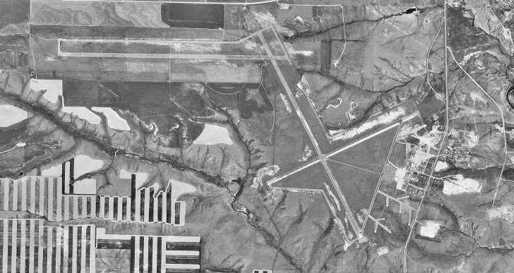
| 1995 USGS Photo |
| IATA: CTB – ICAO: KCTB – FAA LID: CTB |
| Summary |
| Airport type |
Public |
| Owner |
Cut Bank and Glacier County |
| Serves |
Cut Bank, Montana |
| Location |
Glacier County, near Cut Bank, Montana |
| Elevation AMSL |
3,854 ft / 1,175 m |
| Coordinates |
48°36′30″N 112°22′34″W / 48.60833°N 112.37611°W / 48.60833; -112.37611 |
| Website |
CutbankAirport.org |
| Runways |
| Direction |
Length |
Surface |
| ft |
m |
| 5/23 |
5,299 |
1,615 |
Asphalt |
| 13/31 |
5,300 |
1,615 |
Asphalt |
| Statistics (2008) |
| Aircraft operations |
5,800 |
| Based aircraft |
32 |
| Source: Federal Aviation Administration |
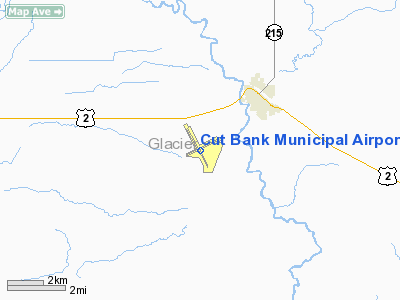
Cut Bank Municipal Airport (IATA: CTB, ICAO: KCTB, FAA LID: CTB) is a public use airport located three nautical miles (6 km) southwest of the central business district of Cut Bank, a city in Glacier County, Montana, United States. It is owned by Cut Bank and Glacier County.
The airport's website refers to it as Cut Bank International Airport. Its first flight took place on 1 June 1941. Facilities and aircraft
Cut Bank Municipal Airport covers an area of 1,730 acres (700 ha) at an elevation of 3,854 feet (1,175 m) above mean sea level. It has two asphalt paved runways: 5/23 is 5,299 by 75 feet (1,615 x 23 m) and 13/31 is 5,300 by 75 feet (1,615 x 23 m).
For the 12-month period ending August 22, 2008, the airport had 5,800 aircraft operations, an average of 15 per day: 90% general aviation, 9% air taxi and 2% military. At that time there were 32 aircraft based at this airport: 88% single-engine, 3% multi-engine and 9% ultralight.
History
During World War II, Cut Bank Army Airfield was used by the Second Air Force as an axillary heavy bomber training airfield, being controlled by Great Falls Army Air Base. Several squadrons of groups training at Great Falls in B-17 Flying Fortresses trained at Cut Bank. Known squadrons were:
- 2nd Bombardment Group, 429th Bomb Squadron, November 1942-March 1943
- 385th Bombardment Group, 550th Bomb Squadron, March-June 1943
- 390th Bombardment Group, 569th Bomb Squadron, June-July 1943
- 401st Bombardment Group, 613th Bomb Squadron, July-October 1943
During the Cold War, Cut Bank AFB was used as an interceptor base as part of Air Defense Command.
The above content comes from Wikipedia and is published under free licenses – click here to read more.
Location & QuickFacts
| FAA Information Effective: | 2008-09-25 |
| Airport Identifier: | CTB |
| Airport Status: | Operational |
| Longitude/Latitude: | 112-22-34.1270W/48-36-30.0760N
-112.376146/48.608354 (Estimated) |
| Elevation: | 3854 ft / 1174.70 m (Surveyed) |
| Land: | 1730 acres |
| From nearest city: | 3 nautical miles SW of Cut Bank, MT |
| Location: | Glacier County, MT |
| Magnetic Variation: | 17E (1995) |
Owner & Manager
| Ownership: | Publicly owned |
| Owner: | Cut Bank And Glacier Co |
| Address: | P.o. Box 130
Cut Bank, MT 59427 |
| Phone number: | 406-873-8683 |
| Manager: | David Ries |
| Address: | P.o.box 130
Cut Bank, MT 59427 |
| Phone number: | 406-229-0376 |
Airport Operations and Facilities
| Airport Use: | Open to public |
| Wind indicator: | Yes |
| Segmented Circle: | Yes |
| Control Tower: | No |
| Lighting Schedule: | DUSK-DAWN
ACTVT MIRL RYS 05/23 & 13/31; PAPI RY 23; REIL RY 31 - CTAF. VASI RY 31 ON 24 HRS. |
| Beacon Color: | Clear-Green (lighted land airport) |
| Landing fee charge: | No |
| Sectional chart: | Great Falls |
| Region: | ANM - Northwest Mountain |
| Boundary ARTCC: | ZLC - Salt Lake City |
| Tie-in FSS: | GTF - Great Falls |
| FSS on Airport: | No |
| FSS Toll Free: | 1-800-WX-BRIEF |
| NOTAMs Facility: | CTB (NOTAM-d service avaliable) |
| Federal Agreements: | NGPY3 |
Airport Communications
| CTAF: | 122.800 |
| Unicom: | 122.800 |
Airport Services
| Fuel available: | 100LLA |
| Airframe Repair: | MAJOR |
| Power Plant Repair: | MAJOR |
| Bottled Oxygen: | NONE |
| Bulk Oxygen: | NONE |
Runway Information
Runway 05/23
| Dimension: | 5299 x 75 ft / 1615.1 x 22.9 m |
| Surface: | ASPH, Good Condition |
| Surface Treatment: | Porous Friction Course |
| Weight Limit: | Single wheel: 12000 lbs. |
| Edge Lights: | Medium |
| |
Runway 05 |
Runway 23 |
| Longitude: | 112-23-06.7840W | 112-21-55.9710W |
| Latitude: | 48-36-23.3620N | 48-36-46.3460N |
| Elevation: | 3850.00 ft | 3836.00 ft |
| Alignment: | 64 | 127 |
| Traffic Pattern: | Left | Left |
| Markings: | Basic, Good Condition | Basic, Good Condition |
| Crossing Height: | 0.00 ft | 40.00 ft |
| VASI: | | 2-light PAPI on left side |
| Visual Glide Angle: | 0.00° | 3.00° |
|
Runway 13/31
| Dimension: | 5300 x 75 ft / 1615.4 x 22.9 m |
| Surface: | ASPH, Good Condition |
| Surface Treatment: | Porous Friction Course |
| Weight Limit: | Single wheel: 12000 lbs. |
| Edge Lights: | Medium |
| |
Runway 13 |
Runway 31 |
| Longitude: | 112-22-55.2810W | 112-22-18.4720W |
| Latitude: | 48-36-48.4180N | 48-36-02.1750N |
| Elevation: | 3854.00 ft | 3838.00 ft |
| Alignment: | 127 | 127 |
| Traffic Pattern: | Left | Left |
| Markings: | Non-precision instrument, Good Condition | Non-precision instrument, Good Condition |
| Crossing Height: | 0.00 ft | 43.00 ft |
| VASI: | | 4-box on left side |
| Visual Glide Angle: | 0.00° | 3.00° |
| Runway End Identifier: | | Yes |
|
Radio Navigation Aids
| ID |
Type |
Name |
Ch |
Freq |
Var |
Dist |
| SBX | NDB | Shelby | | 347.00 | 18E | 20.8 nm |
| CRD | NDB | Conrad | | 293.00 | 17E | 31.4 nm |
| CII | NDB | Choteau | | 269.00 | 17E | 47.9 nm |
| CTB | VORTAC | Cut Bank | 091X | 114.40 | 17E | 2.9 nm |
Remarks
- FOR FUEL AFT HRS CALL 406-873-8683.
- AGRICULTURAL ACFT OPNS FM APR-AUG.
- ON-FIELD CAMPING, PILOTS LOUNGE, RNTL CARS & OVERNIGHT HGR STORAGE.
Images and information placed above are from
http://www.airport-data.com/airport/CTB/
We thank them for the data!
| General Info
|
| Country |
United States
|
| State |
MONTANA
|
| FAA ID |
CTB
|
| Latitude |
48-36-30.076N
|
| Longitude |
112-22-34.127W
|
| Elevation |
3854 feet
|
| Near City |
CUT BANK
|
We don't guarantee the information is fresh and accurate. The data may
be wrong or outdated.
For more up-to-date information please refer to other sources.
|
|