 |
|
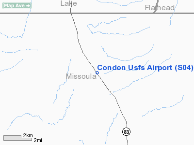
| Condon USFS Airport |
| IATA: none – ICAO: none – FAA LID: S04 |
| Summary |
| Airport type |
Public |
| Owner |
United States Forest Service (USFS) |
| Serves |
Condon, Montana |
| Elevation AMSL |
3,686 ft / 1,123 m |
| Coordinates |
47°32′20″N 113°43′13″W / 47.53889°N 113.72028°W / 47.53889; -113.72028 |
| Runways |
| Direction |
Length |
Surface |
| ft |
m |
| 13/31 |
2,575 |
785 |
Turf |
| Statistics (2008) |
| Aircraft operations |
1,000 |
| Source: Federal Aviation Administration |
Condon USFS Airport (FAA LID: S04) is a public use airport located one nautical mile (1.85 km) northwest of the central business district of Condon, in Missoula County, Montana, United States. It is owned by the United States Forest Service (USFS).
Facilities and aircraft
Condon USFS Airport covers an area of 28 acres (11 ha) at an elevation of 3,686 feet (1,123 m) above mean sea level. It has one runway designated 13/31 with a turf surface measuring 2,575 by 135 feet (785 x 41 m). For the 12-month period ending July 21, 2008, the airport had 1,000 aircraft operations, an average of 83 per month: 80% general aviation and 20% air taxi.
The above content comes from Wikipedia and is published under free licenses – click here to read more.
Location & QuickFacts
| FAA Information Effective: | 2008-09-25 |
| Airport Identifier: | S04 |
| Airport Status: | Operational |
| Longitude/Latitude: | 113-43-13.3260W/47-32-19.7730N
-113.720368/47.538826 (Estimated) |
| Elevation: | 3686 ft / 1123.49 m (Surveyed) |
| Land: | 28 acres |
| From nearest city: | 1 nautical miles NW of Condon, MT |
| Location: | Missoula County, MT |
| Magnetic Variation: | 18E (1985) |
Owner & Manager
| Ownership: | Publicly owned |
| Owner: | Usfs |
| Address: | Flathead National Forest
Kalispell, MT 59901 |
| Phone number: | 406-755-5401 |
| Manager: | Usfs |
| Address: | Condon Ranger Station
Condon, MT 59826 |
| Phone number: | 406-754-2295
ADDITIONAL PHONE NUMBER 406-837-7500 (BIG FORK). |
Airport Operations and Facilities
| Airport Use: | Open to public |
| Wind indicator: | Yes |
| Segmented Circle: | No |
| Control Tower: | No |
| Landing fee charge: | No |
| Sectional chart: | Great Falls |
| Region: | ANM - Northwest Mountain |
| Boundary ARTCC: | ZLC - Salt Lake City |
| Tie-in FSS: | GTF - Great Falls |
| FSS on Airport: | No |
| FSS Toll Free: | 1-800-WX-BRIEF |
| NOTAMs Facility: | GTF (NOTAM-d service avaliable) |
Airport Communications
Airport Services
| Airframe Repair: | NONE |
| Power Plant Repair: | NONE |
| Bottled Oxygen: | NONE |
| Bulk Oxygen: | NONE |
Runway Information
Runway 13/31
| Dimension: | 2575 x 135 ft / 784.9 x 41.1 m
MEASURED FM RY 31 MKD THR TO END OF RY 13 MAINTAINED AREA. |
| Surface: | TURF, Good Condition |
| |
Runway 13 |
Runway 31 |
| Traffic Pattern: | Left | Left |
| Obstruction: | 73 ft trees, 1053.0 ft from runway, 14:1 slope to clear | 88 ft trees, 630.0 ft from runway, 7:1 slope to clear |
|
Radio Navigation Aids
| ID |
Type |
Name |
Ch |
Freq |
Var |
Dist |
| PLS | NDB | Polson | | 275.00 | 20E | 21.2 nm |
| INE | NDB | Konna | | 521.00 | 17E | 38.4 nm |
| SAK | NDB | Smith Lake | | 515.00 | 18E | 45.4 nm |
| MSO | VOR/DME | Missoula | 075X | 112.80 | 17E | 40.7 nm |
| FCA | VOR/DME | Kalispell | 079X | 113.20 | 18E | 44.6 nm |
Remarks
- TREES IN ALL TRANSITIONAL SURFACES.
- NO SNOW REMOVAL.
- EST PRIOR TO 1959
Images and information placed above are from
http://www.airport-data.com/airport/S04/
We thank them for the data!
| General Info
|
| Country |
United States
|
| State |
MONTANA
|
| FAA ID |
S04
|
| Latitude |
47-32-19.773N
|
| Longitude |
113-43-13.326W
|
| Elevation |
3686 feet
|
| Near City |
CONDON
|
We don't guarantee the information is fresh and accurate. The data may
be wrong or outdated.
For more up-to-date information please refer to other sources.
|
|


