 |
|
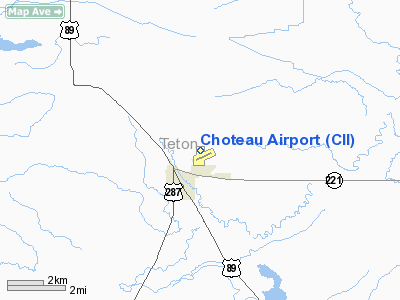
Location & QuickFacts
| FAA Information Effective: | 2008-09-25 |
| Airport Identifier: | CII |
| Airport Status: | Operational |
| Longitude/Latitude: | 112-10-06.0110W/47-49-42.0490N
-112.168336/47.828347 (Estimated) |
| Elevation: | 3947 ft / 1203.05 m (Surveyed) |
| Land: | 495 acres |
| From nearest city: | 1 nautical miles NE of Choteau, MT |
| Location: | Teton County, MT |
| Magnetic Variation: | 17E (1985) |
Owner & Manager
| Ownership: | Publicly owned |
| Owner: | Choteau City And Teton Co |
| Address: | Teton County Court House
Choteau, MT 59422 |
| Phone number: | 406-466-2693 |
| Manager: | Pending |
| Address: | 103 Airport Rd
Choteau, MT 59422 |
| Phone number: | 406-466-2955 |
Airport Operations and Facilities
| Airport Use: | Open to public |
| Wind indicator: | Yes |
| Segmented Circle: | Yes |
| Control Tower: | No |
| Lighting Schedule: | DUSK-DAWN
ACTIVATE MIRL RY 05/23 & RY 14/32; PAPI RY 05 & RY 23 AND RY 14 & RY 32 - 122.8. |
| Beacon Color: | Clear-Green (lighted land airport) |
| Landing fee charge: | No |
| Sectional chart: | Great Falls |
| Region: | ANM - Northwest Mountain |
| Boundary ARTCC: | ZLC - Salt Lake City |
| Tie-in FSS: | GTF - Great Falls |
| FSS on Airport: | No |
| FSS Toll Free: | 1-800-WX-BRIEF |
| NOTAMs Facility: | GTF (NOTAM-d service avaliable) |
| Federal Agreements: | NGY |
Airport Communications
| CTAF: | 122.800 |
| Unicom: | 122.800 |
Airport Services
| Fuel available: | 100LLA |
| Airframe Repair: | MAJOR |
| Power Plant Repair: | MAJOR |
| Bottled Oxygen: | NONE |
| Bulk Oxygen: | NONE |
Runway Information
Runway 05/23
| Dimension: | 3700 x 60 ft / 1127.8 x 18.3 m |
| Surface: | ASPH, |
| Weight Limit: | Single wheel: 12500 lbs. |
| Edge Lights: | Medium |
| |
Runway 05 |
Runway 23 |
| Longitude: | 112-10-22.5490W | 112-09-32.7090W |
| Latitude: | 47-49-23.9910N | 47-49-38.4570N |
| Elevation: | 3947.00 ft | 3939.00 ft |
| Alignment: | 67 | 127 |
| Traffic Pattern: | Left | Left |
| Markings: | Basic, Good Condition | Basic, Good Condition |
| Crossing Height: | 25.00 ft | 23.00 ft |
| VASI: | 2-light PAPI on left side | 2-light PAPI on left side |
| Visual Glide Angle: | 3.00° | 3.00° |
| Obstruction: | , 50:1 slope to clear | 20 ft road, 515.0 ft from runway, 185 ft right of centerline, 20:1 slope to clear
HAS +1O FT ROAD 199 FT FM EOR 127 FT RIGHT & +7 FT FENCE 199 FT FM EOR 156 FT RIGHT. |
|
Runway 14/32
| Dimension: | 5000 x 75 ft / 1524.0 x 22.9 m |
| Surface: | ASPH, Good Condition |
| Weight Limit: | Single wheel: 16000 lbs. |
| Edge Lights: | Medium |
| |
Runway 14 |
Runway 32 |
| Longitude: | 112-10-24.8850W | 112-09-59.5840W |
| Latitude: | 47-50-13.2040N | 47-49-26.9020N |
| Elevation: | 3942.00 ft | 3941.00 ft |
| Alignment: | 127 | 127 |
| Traffic Pattern: | Left | Left |
| Markings: | Non-precision instrument, Good Condition | Non-precision instrument, Good Condition |
| Crossing Height: | 23.00 ft | 25.00 ft |
| VASI: | 2-light PAPI on left side | 2-light PAPI on left side |
| Visual Glide Angle: | 3.00° | 3.00° |
|
Radio Navigation Aids
| ID |
Type |
Name |
Ch |
Freq |
Var |
Dist |
| CII | NDB | Choteau | | 269.00 | 17E | 0.4 nm |
| CRD | NDB | Conrad | | 293.00 | 17E | 23.8 nm |
| ITU | NDB | Truly | | 371.00 | 16E | 42.6 nm |
| SBX | NDB | Shelby | | 347.00 | 18E | 44.6 nm |
| GFA | TACAN | Malmstrom | 105X | | 17E | 44.4 nm |
| GTF | VORTAC | Great Falls | 098X | 115.10 | 16E | 38.1 nm |
| CTB | VORTAC | Cut Bank | 091X | 114.40 | 17E | 44.8 nm |
Images and information placed above are from
http://www.airport-data.com/airport/CII/
We thank them for the data!
| General Info
|
| Country |
United States
|
| State |
MONTANA
|
| FAA ID |
CII
|
| Latitude |
47-49-31.010N
|
| Longitude |
112-09-58.369W
|
| Elevation |
3949 feet
|
| Near City |
CHOTEAU
|
We don't guarantee the information is fresh and accurate. The data may
be wrong or outdated.
For more up-to-date information please refer to other sources.
|
|


