 |
|
| Boulder Airport |
| IATA: none – ICAO: none – FAA LID: 3U9 |
| Summary |
| Airport type |
Public |
| Owner |
Town of Boulder & Jefferson County |
| Serves |
Boulder, Montana |
| Elevation AMSL |
4,968 ft / 1,514 m |
| Coordinates |
46°12′42″N 112°06′21″W / 46.21167°N 112.10583°W / 46.21167; -112.10583 |
| Runways |
| Direction |
Length |
Surface |
| ft |
m |
| 11/29 |
3,675 |
1,120 |
Turf |
| Statistics (2007) |
| Aircraft operations |
600 |
| Source: Federal Aviation Administration |
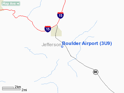
Boulder Airport (FAA LID: 3U9) is a public airport located two miles (3 km) south of the central business district of Boulder, a town in Jefferson County, Montana, United States. It is owned by the Town of Boulder and Jefferson County.
Facilities and aircraft
Boulder Airport covers an area of 32 acres (13 ha) and has one runway designated 11/29 with a turf surface measuring 3,675 by 72 feet (1,120 by 22 m). For the 12-month period ending August 13, 2007, the airport had 600 general aviation aircraft operations, an average of 50 per month.
The above content comes from Wikipedia and is published under free licenses – click here to read more.
Location & QuickFacts
| FAA Information Effective: | 2008-09-25 |
| Airport Identifier: | 3U9 |
| Airport Status: | Operational |
| Longitude/Latitude: | 112-06-20.9960W/46-12-41.7400N
-112.105832/46.211594 (Estimated) |
| Elevation: | 4968 ft / 1514.25 m (Estimated) |
| Land: | 32 acres |
| From nearest city: | 2 nautical miles S of Boulder, MT |
| Location: | Jefferson County, MT |
| Magnetic Variation: | 17E (1985) |
Owner & Manager
| Ownership: | Publicly owned |
| Owner: | Twn Of Boulder & Jefferson Co |
| Address: | County Courthouse Box H
Boulder, MT 59632 |
| Phone number: | 406-225-4025 |
| Manager: | Al Martini |
| Address: | Po Box 2
Boulder, MT 59632 |
| Phone number: | 406-225-9529 |
Airport Operations and Facilities
| Airport Use: | Open to public |
| Wind indicator: | Yes |
| Segmented Circle: | Yes |
| Control Tower: | No |
| Landing fee charge: | No |
| Sectional chart: | Great Falls |
| Region: | ANM - Northwest Mountain |
| Boundary ARTCC: | ZLC - Salt Lake City |
| Tie-in FSS: | GTF - Great Falls |
| FSS on Airport: | No |
| FSS Toll Free: | 1-800-WX-BRIEF |
| NOTAMs Facility: | GTF (NOTAM-d service avaliable) |
Airport Communications
Airport Services
| Airframe Repair: | NONE |
| Power Plant Repair: | NONE |
| Bottled Oxygen: | NONE |
| Bulk Oxygen: | NONE |
Runway Information
Runway 11/29
| Dimension: | 3675 x 72 ft / 1120.1 x 21.9 m |
| Surface: | TURF, Fair Condition
HAS 1% TO 3% UPHILL GRADIENT FROM RY 29 END TO RY 11 END. |
| |
Runway 11 |
Runway 29 |
| Traffic Pattern: | Left | Left |
| Markings: | Basic,
RY 11/29 THLDS MKD WITH RED CONES, EDGES MKD WITH WHITE CONES. | , |
| Obstruction: | 250 ft hill, 5000.0 ft from runway, 20:1 slope to clear | 10 ft road, 216.0 ft from runway, 21:1 slope to clear |
|
Radio Navigation Aids
| ID |
Type |
Name |
Ch |
Freq |
Var |
Dist |
| CVP | NDB | Capitol | | 335.00 | 16E | 24.8 nm |
| HAU | NDB | Hauser | | 386.00 | 16E | 25.9 nm |
| CPN | VOR/DME | Coppertown | 053X | 111.60 | 16E | 28.8 nm |
| BZN | VOR/DME | Bozeman | 071X | 112.40 | 18E | 47.3 nm |
| HIA | VORTAC | Whitehall | 084X | 113.70 | 18E | 21.2 nm |
| HLN | VORTAC | Helena | 124X | 117.70 | 16E | 24.6 nm |
Remarks
- NO SNOW REMOVAL
- NO PHONE ON AIRPORT.
- -2 FT DRAINAGE DITCH +1 FT BERM WEST SIDE OF RY FULL LENGTH; 43 FT FM RY 11/29 CNTRLN.
Images and information placed above are from
http://www.airport-data.com/airport/3U9/
We thank them for the data!
| General Info
|
| Country |
United States
|
| State |
MONTANA
|
| FAA ID |
3U9
|
| Latitude |
46-12-41.740N
|
| Longitude |
112-06-20.996W
|
| Elevation |
4968 feet
|
| Near City |
BOULDER
|
We don't guarantee the information is fresh and accurate. The data may
be wrong or outdated.
For more up-to-date information please refer to other sources.
|
|


