 |
|
Billings Logan International Airport |
| Billings Logan International Airport |
| IATA: BIL – ICAO: KBIL – FAA LID: BIL |
| Summary |
| Airport type |
Public |
| Owner |
City of Billings |
| Serves |
Billings, Montana |
| Hub for |
Great Lakes Airlines |
| Elevation AMSL |
3,652 ft / 1,113 m |
| Coordinates |
45°48′28″N 108°32′34″W / 45.80778°N 108.54278°W / 45.80778; -108.54278 |
| Website |
www.flybillings.com |
| Runways |
| Direction |
Length |
Surface |
| ft |
m |
| 7/25 |
5,501 |
1,677 |
Asphalt |
| 10L/28R |
10,518 |
3,206 |
Asphalt |
| 10R/28L |
3,801 |
1,159 |
Asphalt |
| Statistics (2009) |
| Aircraft operations |
83,500 |
| Based aircraft |
167 |
| Source: Federal Aviation Administration |
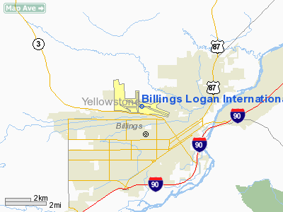
Billings Logan International Airport (IATA: BIL, ICAO: KBIL, FAA LID: BIL) is a public-use airport located two nautical miles (3.7 km) northwest of the central business district of Billings, in Yellowstone County, Montana, United States. The airport is owned by the City of Billings. It serves residents of the greater Billings Metro area as well as residents throughout South Central Montana, eastern Montana and northern Wyoming.
No regularly-scheduled, non-stop flights from Billings travel farther east than Chicago, farther south than Phoenix, or farther west than Seattle. The airport offers non-stop flights to major airline hubs such as Denver International Airport (United Airlines and Frontier Airlines), Chicago O'Hare International Airport (United Airlines), Salt Lake City International Airport (Delta Connection), Minneapolis-St. Paul International Airport (Northwest Airlines), and Seattle-Tacoma International Airport (Horizon Air). HistoryThe first recorded flight in Billings was in 1912 by a local dentist named Dr. Frank Bell. The flight was flown in his home-made airplane Curtiss 0-X-5.
The "First" flight was made on Memorial Day 1913, with much publicity, Dr. Bell took off from Billings flying to Park City and back, a round trip distance of 40 miles (64 km). This historic flight was captured by a local artist named J.K. Ralston in his painting entitled "First Flight," which is displayed in the lobby of the Billings Logan International Airport.
By 1927, the people of Billings realized that the community was in need of an airport. The City of Billings approved $5,000 and 400 acres (162 ha) on top of the Rims to construct a runway. The 1,820-foot (550 m) runway and small administrative building was constructed by using a horse-drawn equipment. The runway and building was completed in 1928. The Billings Municipal Airport was opened on May 29, 1928.
After the airport was established, Northwest Airlines was the first major airline to begin air services to Billings in 1933.
Major improvements over the years include the first runway lights installed in 1935 to the new 120-foot (37 m) air traffic control tower completed in 2005. Major terminal expansions were made in 1958, 1972 and 1992. In early 2006, the airport added electronic monitors that provide real-time updates on flight arrivals and departures.
The airport changed from the Billings Municipal Airport to Billings Logan Field in 1957, after Dick Logan, the airport manager, died. Then in 1971 the airport was renamed Billings Logan International Airport.
The airport is called "International" because it provided flights to Canada.
Great Lakes Airlines has been given USDOT approval to take over Essential Air Service (EAS) between Billings Logan International and the seven eastern Montana EAS communities including Glendive, Glasgow, Havre, Lewistown, Miles City, Sidney, and Wolf Point.
Facilities and aircraft
Billings Logan International Airport covers an area of 2,300 acres (931 ha) at an elevation of 3,652 feet (1,113 m) above mean sea level. It has three asphalt paved runways: 10L/28R is 10,518 by 150 feet (3,206 x 46 m), 10R/28L is 3,801 by 75 feet (1,159 x 23 m), and 7/25 is 5,501 by 75 feet (1,677 x 23 m).
For the 12-month period ending December 31, 2009, the airport had 83,500 aircraft operations, an average of 228 per day: 55% general aviation, 31% air taxi, 14% scheduled commercial, and <1% military. At that time there were 167 aircraft based at this airport: 55% single-engine, 35% multi-engine, 7% jet, and 4% helicopter.
Airlines and destinations
| Airlines |
Destinations |
Concourse |
| Allegiant Air |
Las Vegas, Los Angeles, Phoenix/Mesa |
B |
| Delta Air Lines |
Minneapolis/St. Paul [seasonal] |
A |
| Delta Connection operated by Compass Airlines |
Minneapolis/St. Paul |
A |
| Delta Connection operated by SkyWest Airlines |
Salt Lake City |
B |
| Frontier Airlines operated by Republic Airlines |
Denver |
B |
| Great Lakes Airlines |
Denver, Gillette (WY), Glasgow, Havre, Lewistown, Sidney, Wolf Point |
B |
| Horizon Air |
Seattle/Tacoma |
B |
| United Airlines |
Denver |
A |
| United Express operated by SkyWest Airlines |
Chicago-O’Hare [seasonal], Denver |
A |
Cargo carriers
- FedEx Express
- UPS Airlines
The above content comes from Wikipedia and is published under free licenses – click here to read more.
Location & QuickFacts
| FAA Information Effective: | 2008-09-25 |
| Airport Identifier: | BIL |
| Airport Status: | Operational |
| Longitude/Latitude: | 108-32-34.4000W/45-48-27.6000N
-108.542889/45.807667 (Estimated) |
| Elevation: | 3652 ft / 1113.13 m (Surveyed) |
| Land: | 2300 acres |
| From nearest city: | 2 nautical miles NW of Billings, MT |
| Location: | Yellowstone County, MT |
| Magnetic Variation: | 14E (1990) |
Owner & Manager
| Ownership: | Publicly owned |
| Owner: | City Of Billings |
| Address: | City Hall
Billings, MT 59101 |
| Phone number: | 406-657-8495 |
| Manager: | Thomas Binford, Director |
| Address: | 1901 Terminal Circle Dr, Room 216, Room 216
Billings, MT 59105 |
| Phone number: | 406-657-8433 |
Airport Operations and Facilities
| Airport Use: | Open to public |
| Wind indicator: | Yes |
| Segmented Circle: | Yes |
| Control Tower: | Yes |
| Lighting Schedule: | DUSK-DAWN
FOR MIRL RYS 10R/28L & 07/25; HIRL RY 10L/28R; MALSR RY 10L & REIL RYS 25 & 28R - CTC ATCT. |
| Beacon Color: | Clear-Green (lighted land airport) |
| Landing fee charge: | No |
| Sectional chart: | Billings |
| Region: | ANM - Northwest Mountain |
| Boundary ARTCC: | ZLC - Salt Lake City |
| Tie-in FSS: | GTF - Great Falls |
| FSS Toll Free: | 1-800-WX-BRIEF |
| NOTAMs Facility: | BIL (NOTAM-d service avaliable) |
| Certification type/date: | I C S 05/1973
PPR UNSKED ACR OPNS WITH MORE THAN 30 PSGR SEATS CTC ARPT OPS 406-657-8496. ARFF INDEX B FROM 0100-0600. |
| Federal Agreements: | NGY3 |
Airport Communications
Airport Services
| Fuel available: | 100LLA |
| Airframe Repair: | MAJOR |
| Power Plant Repair: | MAJOR |
| Bottled Oxygen: | HIGH/LOW |
| Bulk Oxygen: | HIGH/LOW |
Runway Information
Runway 07/25
| Dimension: | 5501 x 75 ft / 1676.7 x 22.9 m |
| Surface: | ASPH, Good Condition |
| Surface Treatment: | Saw-cut or plastic Grooved |
| Weight Limit: | Single wheel: 12500 lbs. |
| Edge Lights: | Medium |
| |
Runway 07 |
Runway 25 |
| Longitude: | 108-33-30.2256W | 108-32-13.0247W |
| Latitude: | 45-48-27.6274N | 45-48-33.3197N |
| Elevation: | 3636.00 ft | 3534.00 ft |
| Alignment: | 84 | 127 |
| Traffic Pattern: | Left | Left |
| Markings: | Non-precision instrument, Good Condition | Non-precision instrument, Good Condition |
| Crossing Height: | 27.00 ft | 35.00 ft |
| VASI: | 4-light PAPI on left side | 4-light PAPI on right side |
| Visual Glide Angle: | 3.00° | 3.00° |
| Runway End Identifier: | | Yes |
| Obstruction: | 20 ft gnd, 600.0 ft from runway, 20:1 slope to clear | , 50:1 slope to clear |
|
Runway 10L/28R
| Dimension: | 10518 x 150 ft / 3205.9 x 45.7 m |
| Surface: | ASPH, Good Condition |
| Surface Treatment: | Porous Friction Course |
| Weight Limit: | Single wheel: 130000 lbs.
Dual wheel: 170000 lbs.
Dual tandem wheel: 285000 lbs. |
| Edge Lights: | High |
| |
Runway 10L |
Runway 28R |
| Longitude: | 108-33-17.3446W | 108-30-59.4449W |
| Latitude: | 45-48-45.8121N | 45-48-07.3881N |
| Elevation: | 3584.00 ft | 3488.00 ft |
| Alignment: | 111 | 127 |
| ILS Type: | ILS
| ILS/DME
|
| Traffic Pattern: | Left | Left |
| Markings: | Precision instrument, Good Condition | Precision instrument, Good Condition |
| Crossing Height: | 0.00 ft | 56.00 ft |
| VASI: | 4-light PAPI on left side | 4-light PAPI on right side |
| Visual Glide Angle: | 0.00° | 3.00° |
| RVR Equipment: | touchdown | |
| Approach lights: | MALSR | |
| Runway End Identifier: | | Yes |
| Obstruction: | , 50:1 slope to clear | 12 ft gnd, 200.0 ft from runway, 400 ft left of centerline
+12' GND 0-200' FM RY END 400' L. |
|
Runway 10R/28L
| Dimension: | 3801 x 75 ft / 1158.5 x 22.9 m |
| Surface: | ASPH, Good Condition |
| Weight Limit: | Single wheel: 12000 lbs. |
| Edge Lights: | Medium |
| |
Runway 10R |
Runway 28L |
| Longitude: | 108-33-46.1482W | 108-32-56.2928W |
| Latitude: | 45-48-33.0659N | 45-48-19.2267N |
| Elevation: | 3652.00 ft | 3607.00 ft |
| Alignment: | 111 | 127 |
| Traffic Pattern: | Left | Left |
| Markings: | Basic, Fair Condition | Basic, Fair Condition |
| Obstruction: | 52 ft gnd, 2251.0 ft from runway, 40:1 slope to clear | , 50:1 slope to clear |
|
Radio Navigation Aids
| ID |
Type |
Name |
Ch |
Freq |
Var |
Dist |
| RPX | NDB | Roundup | | 362.00 | 17E | 40.5 nm |
| RED | NDB | Red Lodge | | 203.00 | 17E | 45.7 nm |
| BIL | VORTAC | Billings | 092X | 114.50 | 14E | 3.4 nm |
Remarks
- SNOW REMOVAL OPNS IN PROGRESS WINTER MONTHS.
- 180 DEG TURNS RY 10L/28R BY ACFT OVER 25000 LBS PROHIBITED.
- MIGRATORY WATERFOWL INVOF ARPT.
- RYS 07/25 AND 10R/28L CLSD TO ACFT OVER 12,500 LBS.
Images and information placed above are from
http://www.airport-data.com/airport/BIL/
We thank them for the data!
| General Info
|
| Country |
United States
|
| State |
MONTANA
|
| FAA ID |
BIL
|
| Latitude |
45-48-27.585N
|
| Longitude |
108-32-34.300W
|
| Elevation |
3649 feet
|
| Near City |
BILLINGS
|
We don't guarantee the information is fresh and accurate. The data may
be wrong or outdated.
For more up-to-date information please refer to other sources.
|
|


