 |
|
Waynesville - St. Robert Regional Arpt Airport |
Waynesville-St. Robert Regional Airport
Forney Field |
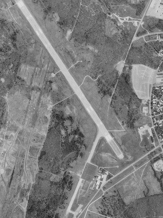 |
| USGS aerial image - 13 April 1995 |
| IATA: TBN – ICAO: KTBN – FAA LID: TBN |
| Summary |
| Airport type |
Public / Military |
| Owner |
U.S. Army |
| Serves |
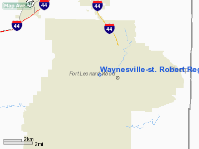
Waynesville & St. Robert, Missouri |
| Location |
Fort Leonard Wood |
| Elevation AMSL |
1,159 ft / 353 m |
| Coordinates |
37°44′30″N 092°08′27″W / 37.74167°N 92.14083°W / 37.74167; -92.14083 |
| Runways |
| Direction |
Length |
Surface |
| ft |
m |
| 14/32 |
6,038 |
1,840 |
Asphalt |
| Statistics (2006) |
| Aircraft operations |
20,653 |
| Source: Federal Aviation Administration |
Waynesville-St. Robert Regional Airport (IATA: TBN, ICAO: KTBN, FAA LID: TBN), also known as Forney Field, is a public and military use airport located at Fort Leonard Wood in Pulaski County, Missouri, United States. The airport's passenger terminal is operated under the control of the U.S. Army and general aviation is under the direction of a board named by the cities of Waynesville and St. Robert. Formerly known as Waynesville Regional Airport at Forney Field, it is served by one commercial airline with scheduled service subsidized by the Essential Air Service program. History
During World War II the airfield was used by the United States Army Air Force. It was known as Forney Army Airfield until 1998. It was attached to Fort Leonard Wood and was part of the Army Service Forces.
Facilities and aircraft
Waynesville-St. Robert Regional Airport covers an area of 237 acres (96 ha) at an elevation of 1,159 feet (353 m) above mean sea level. It has one runway designated 14/32 with an asphalt surface measuring 6,038 by 150 feet (1,840 x 46 m). For the 12-month period ending July 31, 2006, the airport had 20,653 aircraft operations, an average of 56 per day: 59% military, 31% general aviation, 7% scheduled commercial and 3% air taxi.
Airlines and destinations
| Airlines |
Destinations |
| Great Lakes Airlines |
Kansas City, St. Louis |
| Cape Air |
St. Louis TBA |
The above content comes from Wikipedia and is published under free licenses – click here to read more.
Location & QuickFacts
| FAA Information Effective: | 2008-09-25 |
| Airport Identifier: | TBN |
| Airport Status: | Operational |
| Longitude/Latitude: | 092-08-26.6500W/37-44-29.8720N
-92.140736/37.741631 (Estimated) |
| Elevation: | 1159 ft / 353.26 m (Surveyed) |
| Land: | 237 acres |
| From nearest city: | 0 nautical miles SW of Fort Leonard Wood, MO |
| Location: | Pulaski County, MO |
| Magnetic Variation: | 03E (1985) |
Owner & Manager
| Ownership: | Army owned |
| Owner: | U S Army |
| Address: | Forney Army Airfield
Ft Leonard Wood, MO 65473 |
| Phone number: | 573-596-0651 |
| Manager: | Gary Chick |
| Address: | Forney Army Airfield
Ft Leonard Wood, MO 65473 |
| Phone number: | 573-596-0165 |
Airport Operations and Facilities
| Airport Use: | Open to public |
| Wind indicator: | Yes |
| Segmented Circle: | No |
| Control Tower: | Yes |
| Lighting Schedule: | DUSK-DAWN
WHEN TWR CLSD ACTVT HIRL RY 14/32; MALSR & VASI & REIL RY 14 & MALS; VASI & REIL RY 32 - 125.4. |
| Beacon Color: | Split-Clear-Green (lighted military airport) |
| Sectional chart: | Kansas City |
| Region: | ACE - Central |
| Boundary ARTCC: | ZKC - Kansas City |
| Tie-in FSS: | COU - Columbia |
| FSS on Airport: | No |
| FSS Toll Free: | 1-800-WX-BRIEF |
| NOTAMs Facility: | TBN (NOTAM-d service avaliable) |
| Federal Agreements: | N |
Airport Communications
Airport Services
| Fuel available: | 100LLA
PPR RQR MIL JP8 AVBL 1230-2130Z++MON-FRI EXC HOL, OT FOR CODE 6 & ABOVE. (NC-100LL, JET A AVBL 1400-2300Z++ C573-329-4216). |
| Airframe Repair: | NONE |
| Power Plant Repair: | NONE |
| Bottled Oxygen: | NONE |
| Bulk Oxygen: | NONE |
Runway Information
Runway 14/32
| Dimension: | 6038 x 150 ft / 1840.4 x 45.7 m |
| Surface: | ASPH, Good Condition |
| Weight Limit: | Single wheel: 50000 lbs. |
| Edge Lights: | High |
| |
Runway 14 |
Runway 32 |
| Longitude: | 092-08-47.0300W | 092-08-06.2750W |
| Latitude: | 37-44-54.9470N | 37-44-04.7950N |
| Elevation: | 1158.00 ft | 1154.00 ft |
| Alignment: | 127 | 127 |
| ILS Type: | ILS/DME
| |
| Traffic Pattern: | Left | Right |
| Markings: | Precision instrument, Good Condition | Precision instrument, Good Condition |
| Crossing Height: | 36.00 ft | 36.00 ft |
| Displaced threshold: | 501.00 ft | 526.00 ft |
| VASI: | 2-box on left side | 2-box on right side |
| Visual Glide Angle: | 2.90° | 2.90° |
| RVR Equipment: | | touchdown |
| Approach lights: | MALSR
MALSR OTS INDEFLY. | MALS |
| Runway End Identifier: | Yes | Yes |
| Centerline Lights: | No | No |
| Touchdown Lights: | No | No |
| Obstruction: | 9 ft pole, 210.0 ft from runway, 450 ft left of centerline, 1:1 slope to clear
50:1 TO DSPLCD THR. | 17 ft road, 450.0 ft from runway, 14:1 slope to clear
50:1 TO DSPLCD THR.
+15' GND AT 200'; 200-500' R CTRLN; OBST LIGHTED FENCE. |
|
Radio Navigation Aids
| ID |
Type |
Name |
Ch |
Freq |
Var |
Dist |
| BHN | NDB | Buckhorn | | 391.00 | 03E | 3.2 nm |
| IEB | NDB | Lebanon | | 414.00 | 03E | 26.7 nm |
| AIZ | NDB | Kaiser | | 377.00 | 05E | 28.9 nm |
| UBX | NDB | Cuba | | 380.00 | 01E | 39.0 nm |
| JE | NDB | Algoa | | 397.00 | 03E | 48.6 nm |
| MNF | NDB | Mountain View | | 365.00 | 03E | 49.4 nm |
| SHY | VOR/DME | Sunshine | 021X | 108.40 | 05E | 28.3 nm |
| VIH | VOR/DME | Vichy | 124X | 117.70 | 06E | 32.2 nm |
| MAP | VORTAC | Maples | 081X | 113.40 | 06E | 19.1 nm |
Remarks
- RSTD: PPR FOR ALL TRAN MIL ACFT DSN 581-0165/4819; C573-596-0165/4819.
- SFC VSBY LIMITED BY TREE LINE FM E TO S TO W.
- WX FCST NOT AVBL LCL. REMOTE BRIEFING SVC AVBL 26 OWS BARKSDALE AFB DSN 781-4775, C318-456-4775, C866-223-2398 (TOLL FREE), FAX DSN 781-3493 OR C318-456-3493, WEB SITE HTTPS://26OWS.BARKSDALE.AF.MIL/.
- MISC: WX OBSERVER AUGMENTED 1200-0300Z++MON-FRI, 1300-2100Z++SAT, 1700-0100Z++SUN.
Images and information placed above are from
http://www.airport-data.com/airport/TBN/
We thank them for the data!
| General Info
|
| Country |
United States
|
| State |
MISSOURI
|
| FAA ID |
TBN
|
| Latitude |
37-44-29.872N
|
| Longitude |
092-08-26.650W
|
| Elevation |
1159 feet
|
| Near City |
FORT LEONARD WOOD
|
We don't guarantee the information is fresh and accurate. The data may
be wrong or outdated.
For more up-to-date information please refer to other sources.
|
|


