 |
|
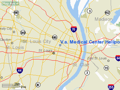
V.A. Medical Center Heliport |
Location & QuickFacts
| FAA Information Effective: | 2008-09-25 |
| Airport Identifier: | MU06 |
| Airport Status: | Operational |
| Longitude/Latitude: | 090-13-50.4030W/38-38-32.1840N
-90.230667/38.642273 (Estimated) |
| Elevation: | 550 ft / 167.64 m (Estimated) |
| Land: | 0 acres |
| From nearest city: | 0 nautical miles N of St Louis, MO |
| Location: | St Louis County, MO |
| Magnetic Variation: | 02E (1985) |
Owner & Manager
| Ownership: | Publicly owned |
| Owner: | V.a. Medical Center |
| Address: | 915 N Grand Blvd
St Louis, MO 63125 |
| Phone number: | 573-894-6661 |
| Manager: | Donald L Ziegenhorn |
| Address: | 915 N. Grand Blvd
St Louis, MO 63125 |
| Phone number: | 314-289-6470
EXT 601 |
Airport Operations and Facilities
| Airport Use: | Private
MEDICAL. |
| Wind indicator: | Yes |
| Segmented Circle: | No |
| Control Tower: | No |
| Lighting Schedule: | PHONE REQ
FOR ROTG BCN & PERIMETER LGTS PHONE 314-289-6330 FROM 0800-1630 MON-FRI; OTHER TIMES 314-652-4100 EXT 4444. |
| Beacon Color: | Clear-Green-Yellow (heliport) |
| Landing fee charge: | No |
| Sectional chart: | St Louis |
| Region: | ACE - Central |
| Boundary ARTCC: | ZKC - Kansas City |
| Tie-in FSS: | STL - Saint Louis |
| FSS on Airport: | No |
| FSS Toll Free: | 1-800-WX-BRIEF |
Runway Information
Helipad H1
| Dimension: | 20 x 20 ft / 6.1 x 6.1 m |
| Surface: | CONC, |
| |
Runway H1 |
Runway |
| Traffic Pattern: | Left | Left |
|
Radio Navigation Aids
| ID |
Type |
Name |
Ch |
Freq |
Var |
Dist |
| LM | NDB | Oblio | | 338.00 | 00E | 14.9 nm |
| CVM | NDB | Civic Memorial | | 263.00 | 02E | 17.1 nm |
| BL | NDB | Belleville | | 362.00 | 02E | 24.7 nm |
| FES | NDB | Festus | | 269.00 | 01E | 27.8 nm |
| SAR | NDB | Sparta | | 239.00 | 01E | 38.9 nm |
| LTD | NDB | Litchfield | | 371.00 | 01E | 40.8 nm |
| SKE | TACAN | Scott | 059X | | 02E | 18.7 nm |
| CSX | VOR/DME | Cardinal | 111Y | 116.45 | 00E | 9.0 nm |
| TOY | VORTAC | Troy | 107X | 116.00 | 04E | 15.8 nm |
| STL | VORTAC | St Louis | 121X | 117.40 | 01E | 17.7 nm |
| FTZ | VORTAC | Foristell | 045X | 110.80 | 05E | 34.9 nm |
| STL | VOT | St Louis Lambert | | 111.00 | | 8.9 nm |
| SUS | VOT | Spirit Of St Louis | | 112.20 | | 19.8 nm |
Remarks
- E111 PRVDD APCH/DEP PATHS TO THE LNDG AREA ARE MAINTD FOR A MIN 8:1 GS & THE TRSNL SFC MAINTD FOR A MIN 2:1 SLOPE.
Images and information placed above are from
http://www.airport-data.com/airport/MU06/
We thank them for the data!
| General Info
|
| Country |
United States
|
| State |
MISSOURI
|
| FAA ID |
MU06
|
| Latitude |
38-38-32.184N
|
| Longitude |
090-13-50.403W
|
| Elevation |
550 feet
|
| Near City |
ST LOUIS
|
We don't guarantee the information is fresh and accurate. The data may
be wrong or outdated.
For more up-to-date information please refer to other sources.
|
|


