 |
|
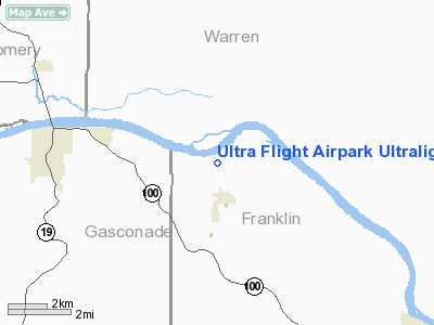
Ultra Flight Airpark Ultralight |
Location & QuickFacts
| FAA Information Effective: | 2008-09-25 |
| Airport Identifier: | 3MO2 |
| Airport Status: | Operational |
| Longitude/Latitude: | 091-20-27.5690W/38-41-27.1660N
-91.340991/38.690879 (Estimated) |
| Elevation: | 502 ft / 153.01 m (Estimated) |
| Land: | 60 acres |
| From nearest city: | 1 nautical miles NE of Berger, MO |
| Location: | Franklin County, MO |
| Magnetic Variation: | 02E (1990) |
Owner & Manager
| Ownership: | Privately owned |
| Owner: | Gregory M. Capobianco
AND JACK C. WILHITE. |
| Address: | 926 Woodcrest Lane
Hazelwood, MO 63042 |
| Phone number: | 314-352-0949 |
| Manager: | Greg Capobianco/jack Wilhite |
| Address: | 926 Woodcrest Lane
Hazelwood, MO 63042 |
| Phone number: | 314-352-0949 |
Airport Operations and Facilities
| Airport Use: | Private |
| Segmented Circle: | No |
| Control Tower: | No |
| Sectional chart: | Kansas City |
| Region: | ACE - Central |
| Boundary ARTCC: | ZKC - Kansas City |
| Tie-in FSS: | STL - Saint Louis |
| FSS on Airport: | No |
| FSS Toll Free: | 1-800-WX-BRIEF |
Runway Information
Runway ALL/WAY
| Dimension: | 1500 x 1500 ft / 457.2 x 457.2 m |
| Surface: | TURF, |
| |
Runway ALL |
Runway WAY |
| Traffic Pattern: | Left | Left |
|
Radio Navigation Aids
| ID |
Type |
Name |
Ch |
Freq |
Var |
Dist |
| UUV | NDB | Sullivan | | 356.00 | 02E | 28.6 nm |
| FTT | NDB | Guthrie | | 317.00 | 03E | 32.4 nm |
| JE | NDB | Algoa | | 397.00 | 03E | 35.4 nm |
| UBX | NDB | Cuba | | 380.00 | 01E | 37.8 nm |
| LM | NDB | Oblio | | 338.00 | 00E | 41.1 nm |
| ONH | NDB | Noah | | 515.00 | 03E | 42.5 nm |
| VIH | VOR/DME | Vichy | 124X | 117.70 | 06E | 36.6 nm |
| COU | VOR/DME | Columbia | 039X | 110.20 | 03E | 41.8 nm |
| CSX | VOR/DME | Cardinal | 111Y | 116.45 | 00E | 46.1 nm |
| FTZ | VORTAC | Foristell | 045X | 110.80 | 05E | 17.3 nm |
| STL | VORTAC | St Louis | 121X | 117.40 | 01E | 41.5 nm |
| HLV | VORTAC | Hallsville | 089X | 114.20 | 06E | 44.7 nm |
| SUS | VOT | Spirit Of St Louis | | 112.20 | | 32.4 nm |
| JEF | VOT | Jefferson City | | 112.00 | | 38.4 nm |
| STL | VOT | St Louis Lambert | | 111.00 | | 46.0 nm |
Remarks
- APCH TO EACH RY MAINTAINED FOR A MINIMUM 20:1 GLIDE SLOPE AND TRANSITIONAL SFC BE MAINTAINED FOR A 7:1 SLOPE.
Images and information placed above are from
http://www.airport-data.com/airport/3MO2/
We thank them for the data!
| General Info
|
| Country |
United States
|
| State |
MISSOURI
|
| FAA ID |
3MO2
|
| Latitude |
38-41-27.166N
|
| Longitude |
091-20-27.569W
|
| Elevation |
502 feet
|
| Near City |
BERGER
|
We don't guarantee the information is fresh and accurate. The data may
be wrong or outdated.
For more up-to-date information please refer to other sources.
|
|


