 |
|
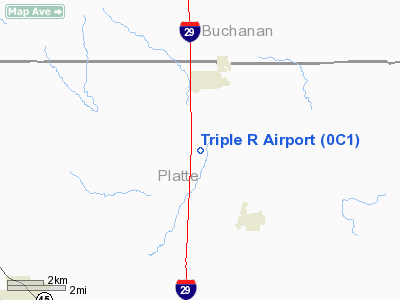
Location & QuickFacts
| FAA Information Effective: | 2008-09-25 |
| Airport Identifier: | 0C1 |
| Airport Status: | Operational |
| Longitude/Latitude: | 094-46-49.8000W/39-29-16.2000N
-94.780500/39.487833 (Estimated) |
| Elevation: | 1000 ft / 304.80 m (Estimated) |
| Land: | 20 acres |
| From nearest city: | 2 nautical miles S of Dearborn, MO |
| Location: | Platte County, MO |
| Magnetic Variation: | 05E (1985) |
Owner & Manager
| Ownership: | Privately owned |
| Owner: | Andrew Rottinghaus |
| Address: | 21815 Oilwell Rd
Dearborn, MO 64439 |
| Phone number: | 816-935-9156 |
| Manager: | Andrew Rottinghaus |
| Address: | 21815 Oilwell Road
Dearborn, MO 64439 |
| Phone number: | 816-935-9156 |
Airport Operations and Facilities
| Airport Use: | Open to public |
| Wind indicator: | Yes |
| Segmented Circle: | No |
| Control Tower: | No |
| Lighting Schedule: | RDO-CTL
ACTVT LIRL RY 02/20 - CTAF |
| Sectional chart: | Kansas City |
| Region: | ACE - Central |
| Boundary ARTCC: | ZKC - Kansas City |
| Tie-in FSS: | COU - Columbia |
| FSS Toll Free: | 1-800-WX-BRIEF |
| NOTAMs Facility: | COU (NOTAM-d service avaliable) |
Airport Communications
| CTAF: | 122.700 |
| Unicom: | 122.700 |
Airport Services
| Fuel available: | 100LL |
| Airframe Repair: | MAJOR |
| Power Plant Repair: | MAJOR |
Runway Information
Runway 02/20
| Dimension: | 2375 x 35 ft / 723.9 x 10.7 m |
| Surface: | ASPH-TRTD, Poor Condition
RWY 02/20- PAVEMENT BROKEN WITH LOOSE ROCKS ON RUNWAY. |
| Edge Lights: | Non-standard lighting system
RWY 2/20 NSTD LIRL AND THLD LGTS; THLD LGTS NOT ALIGNED WITH EDGE LGTS. |
| |
Runway 02 |
Runway 20 |
| Longitude: | 094-46-54.4527W | 094-46-45.1465W |
| Latitude: | 39-29-05.0310N | 39-29-27.3688N |
| Traffic Pattern: | Left | Left |
| Markings: | Basic, Good Condition | Basic, Good Condition |
| Obstruction: | 140 ft tower, 3300.0 ft from runway, 260 ft right of centerline, 22:1 slope to clear
+1-11 FT TREES AND BRUSH, 50FT LEFT OF CENTERLINE, 15-195 FT FROM RUNWAY END. | , 50:1 slope to clear |
|
Radio Navigation Aids
| ID |
Type |
Name |
Ch |
Freq |
Var |
Dist |
| DO | NDB | Dotte | | 359.00 | 05E | 16.1 nm |
| GPH | NDB | Mosby | | 284.00 | 03E | 23.6 nm |
| AZN | NDB | Amazon | | 233.00 | 06E | 24.5 nm |
| GQ | NDB | Norge | | 517.00 | 05E | 26.3 nm |
| GKB | NDB | Norge | | 517.00 | 05E | 26.3 nm |
| EZZ | NDB | Cameron | | 394.00 | 03E | 27.7 nm |
| LXT | NDB | Lesumit | | 263.00 | 04E | 37.0 nm |
| TO | NDB | Biloy | | 521.00 | 05E | 47.6 nm |
| RIS | VOR/DME | Riverside | 051X | 111.40 | 05E | 23.7 nm |
| RBA | VOR/DME | Robinson | 019X | 108.20 | 04E | 36.9 nm |
| OJC | VOR/DME | Johnson County | 077X | 113.00 | 06E | 39.0 nm |
| BQS | VOR/DME | Braymer | 049X | 111.20 | 03E | 42.8 nm |
| MCI | VORTAC | Kansas City | 079Y | 113.25 | 05E | 12.3 nm |
| STJ | VORTAC | St Joseph | 102X | 115.50 | 08E | 29.2 nm |
| ANX | VORTAC | Napoleon | 087X | 114.00 | 07E | 38.4 nm |
| TOP | VORTAC | Topeka | 125X | 117.80 | 05E | 41.5 nm |
| MKC | VOT | Kansas City Downtown | | 108.60 | | 23.5 nm |
Remarks
- CALL ARPT MGR TO VERIFY ATTENDANCE.
- NSTD RWY SAFETY AREAS BEYOND EACH RWY END; TERRAIN GRADES, AND INSUF LEGNTH & WIDTH.
- PRVDD A CLEAR APCH TO EACH RY MAINTAINED FOR A 20:1 GLIDE SLOPE; A CLEAR TRANSITIONAL SFC MAINTAINED FOR A 7:1 SLOPE & TREES ON AER 35 ARE REMOVED OR TOPPED TO PROVIDE APPROPRIATE APCH SLOPE CLEARANCE.
Images and information placed above are from
http://www.airport-data.com/airport/0C1/
We thank them for the data!
| General Info
|
| Country |
United States
|
| State |
MISSOURI
|
| FAA ID |
0C1
|
| Latitude |
39-29-15.989N
|
| Longitude |
094-46-49.858W
|
| Elevation |
1000 feet
|
| Near City |
DEARBORN
|
We don't guarantee the information is fresh and accurate. The data may
be wrong or outdated.
For more up-to-date information please refer to other sources.
|
|


