 |
|
Trenton Municipal Airport |
| Trenton Municipal Airport |
| IATA: TRX – ICAO: KTRX – FAA LID: TRX |
| Summary |
| Airport type |
Public |
| Owner |
City of Trenton |
| Serves |
Trenton, Missouri |
| Elevation AMSL |
757 ft / 231 m |
| Coordinates |
40°05′01″N 093°35′26″W / 40.08361°N 93.59056°W / 40.08361; -93.59056 |
| Runways |
| Direction |
Length |
Surface |
| ft |
m |
| 18/36 |
4,310 |
1,314 |
Asphalt |
| Statistics (2007) |
| Aircraft operations |
2,710 |
| Source: Federal Aviation Administration |
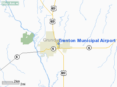
Trenton Municipal Airport (IATA: TRX, ICAO: KTRX, FAA LID: TRX) is a city-owned, public-use airport located one mile (2 km) east of the central business district of Trenton, a city in Grundy County, Missouri, United States.
Facilities and aircraft
Trenton Municipal Airport covers an area of 85 acres (34 ha) and has one runway designated 18/36 with a 4,310 x 75 ft (1,314 x 23 m) asphalt surface. For the 12-month period ending August 22, 2007, the airport had 2,710 aircraft operations, an average of 7 per day: 96% general aviation, 4% air taxi, <1% military.
The above content comes from Wikipedia and is published under free licenses – click here to read more.
Location & QuickFacts
| FAA Information Effective: | 2008-09-25 |
| Airport Identifier: | TRX |
| Airport Status: | Operational |
| Longitude/Latitude: | 093-35-26.2850W/40-05-00.6480N
-93.590635/40.083513 (Estimated) |
| Elevation: | 757 ft / 230.73 m (Surveyed) |
| Land: | 85 acres |
| From nearest city: | 1 nautical miles E of Trenton, MO |
| Location: | Grundy County, MO |
| Magnetic Variation: | 03E (2000) |
Owner & Manager
| Ownership: | Publicly owned |
| Owner: | City Of Trenton |
| Address: | 1100 Main Box 188
Trenton, MO 64683 |
| Phone number: | 660-359-2013 |
| Manager: | John Beier |
| Address: | 1100 Main Box 188
Trenton, MO 64683 |
| Phone number: | 660-359-5154 |
Airport Operations and Facilities
| Airport Use: | Open to public |
| Wind indicator: | Yes |
| Segmented Circle: | No |
| Control Tower: | No |
| Lighting Schedule: | DUSK-DAWN
MIRL RY 18/36 & PAPI RYS 18 & 36 OPER DUSK-2130; AFT 2130 TO DUSK ACTVT MIRL RY 18/36, PAPI RYS 18 & 36, REIL RYS 18 & 36 - CTAF. TO INCR INTST & ACTVT REIL RYS 18 & 36 - CTAF. |
| Beacon Color: | Clear-Green (lighted land airport) |
| Landing fee charge: | No |
| Sectional chart: | Omaha |
| Region: | ACE - Central |
| Boundary ARTCC: | ZKC - Kansas City |
| Tie-in FSS: | COU - Columbia |
| FSS on Airport: | No |
| FSS Toll Free: | 1-800-WX-BRIEF |
| NOTAMs Facility: | COU (NOTAM-d service avaliable) |
| Federal Agreements: | NY1 |
Airport Communications
| CTAF: | 122.800 |
| Unicom: | 122.800 |
Airport Services
| Fuel available: | 100LL
24 HR FUEL AVAILABLE; CONTACT ARPT MGR (660)359-5154; AFTER HRS CONTACT FIRE DEPT (660)359-5552. |
| Bottled Oxygen: | NONE |
| Bulk Oxygen: | NONE |
Runway Information
Runway 18/36
| Dimension: | 4310 x 75 ft / 1313.7 x 22.9 m |
| Surface: | ASPH, Good Condition |
| Edge Lights: | Medium |
| |
Runway 18 |
Runway 36 |
| Longitude: | 093-35-26.6600W | 093-35-25.9500W |
| Latitude: | 40-05-21.9800N | 40-04-39.4200N |
| Elevation: | 757.00 ft | 754.00 ft |
| Alignment: | 127 | 127 |
| Traffic Pattern: | Left | Left |
| Markings: | Non-precision instrument, Good Condition | Non-precision instrument, Good Condition |
| Crossing Height: | 30.00 ft | 30.00 ft |
| Displaced threshold: | 267.00 ft | 400.00 ft |
| VASI: | 4-light PAPI on left side | 4-light PAPI on left side |
| Visual Glide Angle: | 3.00° | 3.00° |
| Runway End Identifier: | Yes | Yes |
| Obstruction: | 21 ft road, 240.0 ft from runway, 1:1 slope to clear
24:1 TO DSPLCD THLD. | 26 ft pole, 269.0 ft from runway, 226 ft right of centerline, 2:1 slope to clear
18:1 BASED ON DSPLCD THLD.
+24 FT UTILITY LINE & POLE, 150-200 FT FM RY END, 185 FT R; +1-6 FT TREE STUMPS & HIGH GND, 0-200 FT FM RY END, 225-250 FT R. |
|
Radio Navigation Aids
| ID |
Type |
Name |
Ch |
Freq |
Var |
Dist |
| TRX | NDB | Trenton | | 400.00 | 03E | 0.2 nm |
| CHT | NDB | Chillicothe | | 375.00 | 03E | 18.9 nm |
| BZK | NDB | Brookfield | | 383.00 | 03E | 29.3 nm |
| EZZ | NDB | Cameron | | 394.00 | 03E | 38.0 nm |
| TVK | NDB | Centerville | | 290.00 | 04E | 48.1 nm |
| BQS | VOR/DME | Braymer | 049X | 111.20 | 03E | 30.2 nm |
| LMN | VORTAC | Lamoni | 114X | 116.70 | 07E | 35.4 nm |
| IRK | VORTAC | Kirksville | 093X | 114.60 | 06E | 46.0 nm |
Remarks
- BE ALERT FOR BIRDS & WILDLIFE ON AND INVOF ARPT.
Images and information placed above are from
http://www.airport-data.com/airport/TRX/
We thank them for the data!
| General Info
|
| Country |
United States
|
| State |
MISSOURI
|
| FAA ID |
TRX
|
| Latitude |
40-05-00.648N
|
| Longitude |
093-35-26.285W
|
| Elevation |
757 feet
|
| Near City |
TRENTON
|
We don't guarantee the information is fresh and accurate. The data may
be wrong or outdated.
For more up-to-date information please refer to other sources.
|
|


