 |
|
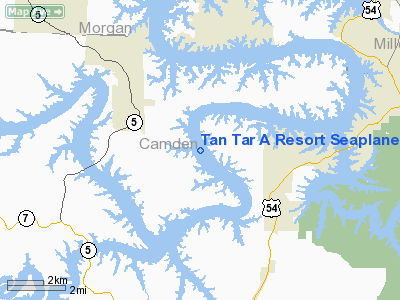
Tan Tar A Resort Seaplane Base |
| Tan-Tar-A Resort Seaplane Base |
| IATA: none – ICAO: none – FAA LID: 19T |
| Summary |
| Airport type |
Public |
| Owner |
Columbia Properties Ozark Ltd. |
| Serves |
Osage Beach, Missouri |
| Elevation AMSL |
659 ft / 201 m |
| Coordinates |
38°08′00″N 092°44′01″W / 38.1333333°N 92.73361°W / 38.1333333; -92.73361 |
| Runways |
| Direction |
Length |
Surface |
| ft |
m |
| NW/SE |
13,000 |
3,962 |
Water |
| Source: Federal Aviation Administration |
Tan-Tar-A Resort Seaplane Base (FAA LID: 19T) is a privately-owned, public-use seaplane base located six nautical miles (11 km) north of the central business district of Osage Beach, in Camden County, Missouri, United States. It is serves the Tan-Tar-A Resort, located on the Lake of the Ozarks.
Facilities
Tan-Tar-A Resort Seaplane Base has one seaplane landing area designated NW/SE which measures 13,000 x 1,200 feet (3,962 x 366 m).
The above content comes from Wikipedia and is published under free licenses – click here to read more.
Location & QuickFacts
| FAA Information Effective: | 2008-09-25 |
| Airport Identifier: | 19T |
| Airport Status: | Operational |
| Longitude/Latitude: | 092-44-00.6710W/38-08-00.1160N
-92.733520/38.133366 (Estimated) |
| Elevation: | 659 ft / 200.86 m (Estimated) |
| Land: | 0 acres |
| From nearest city: | 6 nautical miles N of Osage Beach, MO |
| Location: | Camden County, MO |
| Magnetic Variation: | 04E (1985) |
Owner & Manager
| Ownership: | Privately owned |
| Owner: | Columbia Properties Ozark Lmtd. |
| Address: | Tan Tar A Resort Box 188tt
Osage Beach, MO 65065 |
| Phone number: | 573-348-3131 |
| Manager: | Terri Baer |
| Address: | Tan Tar A Resort Box 188tt
Osage Beach, MO 65065 |
| Phone number: | 573-348-8648 |
Airport Operations and Facilities
| Airport Use: | Open to public |
| Wind indicator: | No |
| Segmented Circle: | No |
| Control Tower: | No |
| Landing fee charge: | No |
| Sectional chart: | Kansas City |
| Region: | ACE - Central |
| Boundary ARTCC: | ZKC - Kansas City |
| Tie-in FSS: | COU - Columbia |
| FSS on Airport: | No |
| FSS Toll Free: | 1-800-WX-BRIEF |
| NOTAMs Facility: | COU (NOTAM-d service avaliable) |
Airport Communications
Airport Services
| Fuel available: | MOGAS
FUEL AVBL FM LOCAL SERVICE STATION. |
| Airframe Repair: | NONE |
| Power Plant Repair: | NONE |
Runway Information
Runway NW/SE
| Dimension: | 13000 x 1200 ft / 3962.4 x 365.8 m
LENGTH & WIDTH MEASURED FROM USGS MAP. |
| Surface: | WATER,
ROUGH SFC CONDITIONS APR-OCT. |
| |
Runway NW |
Runway SE |
| Traffic Pattern: | Left | Left |
|
Radio Navigation Aids
| ID |
Type |
Name |
Ch |
Freq |
Var |
Dist |
| AIZ | NDB | Kaiser | | 377.00 | 05E | 8.8 nm |
| IEB | NDB | Lebanon | | 414.00 | 03E | 34.0 nm |
| ONH | NDB | Noah | | 515.00 | 03E | 38.0 nm |
| BHN | NDB | Buckhorn | | 391.00 | 03E | 39.7 nm |
| JE | NDB | Algoa | | 397.00 | 03E | 39.9 nm |
| DMO | NDB | Sedalia | | 281.00 | 03E | 40.2 nm |
| GLY | NDB | Golden Valley | | 388.00 | 04E | 46.9 nm |
| VER | NDB | Viertel | | 347.00 | 02E | 49.1 nm |
| HCK | NDB | Hawks | | 296.00 | 04E | 49.5 nm |
| TBN | VOR | Forney | | 110.00 | 03E | 36.7 nm |
| SHY | VOR/DME | Sunshine | 021X | 108.40 | 05E | 8.3 nm |
| COU | VOR/DME | Columbia | 039X | 110.20 | 03E | 47.4 nm |
| VIH | VOR/DME | Vichy | 124X | 117.70 | 06E | 48.6 nm |
| JEF | VOT | Jefferson City | | 112.00 | | 38.9 nm |
Remarks
- NO BUOYS SHOWING LANDING AREAS.
- HEAVY BOAT TRAFFIC APR-OCT.
Images and information placed above are from
http://www.airport-data.com/airport/19T/
We thank them for the data!
| General Info
|
| Country |
United States
|
| State |
MISSOURI
|
| FAA ID |
19T
|
| Latitude |
38-08-00.116N
|
| Longitude |
092-44-00.671W
|
| Elevation |
659 feet
|
| Near City |
OSAGE BEACH
|
We don't guarantee the information is fresh and accurate. The data may
be wrong or outdated.
For more up-to-date information please refer to other sources.
|
|


