 |
|
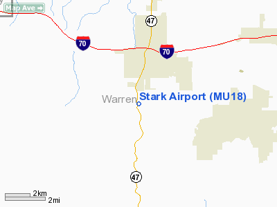
Location & QuickFacts
| FAA Information Effective: | 2008-09-25 |
| Airport Identifier: | MU18 |
| Airport Status: | Operational |
| Longitude/Latitude: | 091-08-50.5360W/38-46-50.1710N
-91.147371/38.780603 (Estimated) |
| Elevation: | 840 ft / 256.03 m (Estimated) |
| Land: | 0 acres |
| From nearest city: | 2 nautical miles SW of Warrenton, MO |
| Location: | Warren County, MO |
| Magnetic Variation: | 03E (1985) |
Owner & Manager
| Ownership: | Privately owned |
| Owner: | Raymond Stark |
| Address: | 389 Dry Fork Rd
Warrenton, MO 63383 |
| Phone number: | 573-456-2475 |
| Manager: | Frank Gross |
| Address: | 389 Dry Fork Rd
Warrenton, MO 63383 |
| Phone number: | 573-338-9211 |
Airport Operations and Facilities
| Airport Use: | Private |
| Wind indicator: | Yes |
| Segmented Circle: | No |
| Control Tower: | No |
| Sectional chart: | Kansas City |
| Region: | ACE - Central |
| Boundary ARTCC: | ZKC - Kansas City |
| Tie-in FSS: | STL - Saint Louis |
| FSS Toll Free: | 1-800-WX-BRIEF |
Runway Information
Runway 09/27
| Dimension: | 1900 x 50 ft / 579.1 x 15.2 m |
| Surface: | ASPH-TURF,
HAS 500 FT ASPH AND 1400 FT TURF SURFACE. |
| |
Runway 09 |
Runway 27 |
| Traffic Pattern: | Left | Left |
|
Radio Navigation Aids
| ID |
Type |
Name |
Ch |
Freq |
Var |
Dist |
| LM | NDB | Oblio | | 338.00 | 00E | 31.5 nm |
| UUV | NDB | Sullivan | | 356.00 | 02E | 32.8 nm |
| FTT | NDB | Guthrie | | 317.00 | 03E | 40.3 nm |
| UBX | NDB | Cuba | | 380.00 | 01E | 45.0 nm |
| JE | NDB | Algoa | | 397.00 | 03E | 45.6 nm |
| CSX | VOR/DME | Cardinal | 111Y | 116.45 | 00E | 36.9 nm |
| VIH | VOR/DME | Vichy | 124X | 117.70 | 06E | 45.9 nm |
| FTZ | VORTAC | Foristell | 045X | 110.80 | 05E | 9.7 nm |
| STL | VORTAC | St Louis | 121X | 117.40 | 01E | 31.5 nm |
| SUS | VOT | Spirit Of St Louis | | 112.20 | | 24.3 nm |
| STL | VOT | St Louis Lambert | | 111.00 | | 36.8 nm |
| JEF | VOT | Jefferson City | | 112.00 | | 48.4 nm |
Remarks
- PRVDD MAINTAIN CLEAR 20:1 APCH AND MAINTAIN CLEAR 7:1 TRANSITIONAL SLOPE.
Images and information placed above are from
http://www.airport-data.com/airport/MU18/
We thank them for the data!
| General Info
|
| Country |
United States
|
| State |
MISSOURI
|
| FAA ID |
MU18
|
| Latitude |
38-46-50.171N
|
| Longitude |
091-08-50.536W
|
| Elevation |
840 feet
|
| Near City |
WARRENTON
|
We don't guarantee the information is fresh and accurate. The data may
be wrong or outdated.
For more up-to-date information please refer to other sources.
|
|


