|
|
St Charles County Smartt Airport |
| St. Charles County Airport |
| IATA: none – ICAO: KSET – FAA LID: SET |
| Summary |
| Airport type |
Public |
| Owner |
St. Charles County, Missouri |
| Serves |
St. Charles, Missouri |
| Elevation AMSL |
437 ft / 133 m |
| Coordinates |
38°55′46.9″N 090°25′47.9″W / 38.929694°N 90.429972°W / 38.929694; -90.429972 |
| Runways |
| Direction |
Length |
Surface |
| ft |
m |
| 09/27 |
2,000 |
610 |
Asphalt |
| 18/36 |
3,800 |
1,158 |
Asphalt |
| Statistics (2007) |
| Aircraft operations |
55,206 |
| Based aircraft |
95 |
| Source: Federal Aviation Administration |
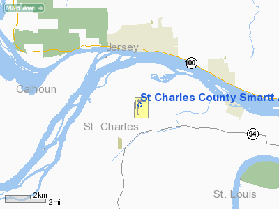
St. Charles County Smartt Airport, also known as Smartt Field, is a public use airport in St. Charles County, Missouri, United States. It is owned by St. Charles County, Missouri and is located nine nautical miles (16.7 km) northeast of the central business district of the city of St. Charles. According to the FAA's National Plan of Integrated Airport Systems for 2007-2011, it is categorized as a reliever airport.
Although most U.S. airports use the same three-letter location identifier for the FAA and IATA, St. Charles County Smartt Airport is assigned SET by the FAA but has no designation from the IATA (which assigned SET to San Esteban Airport in Honduras).
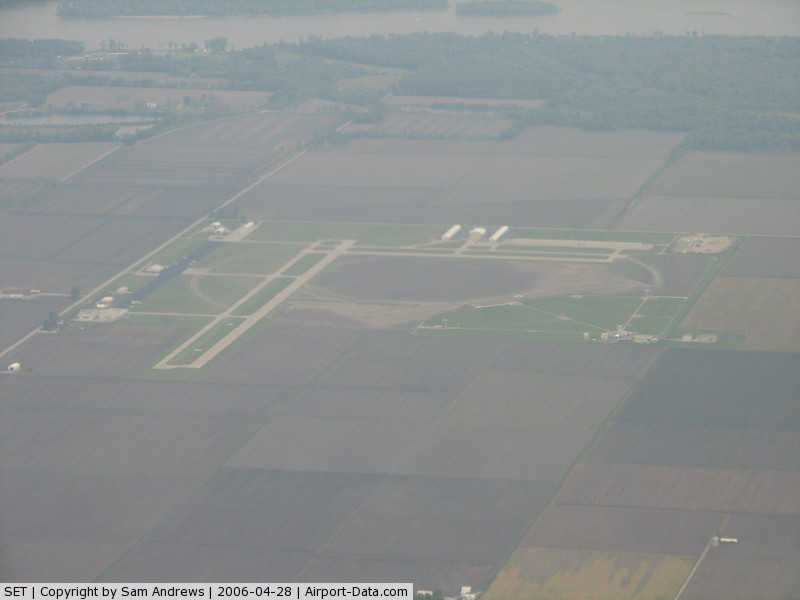
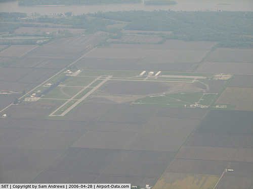
Facilities and aircraft
St. Charles County Smartt Airport covers an area of 312 acres (126 ha) at an elevation of 437 feet (133 m) above mean sea level. It has two asphalt runways: 09/27 measuring 2,000 by 75 feet (610 x 23 m) and 18/36 measuring 3,800 by 75 feet (1,158 x 23 m).
For the 12-month period ending September 24, 2007, the airport had 55,206 aircraft operations, an average of 151 per day: 100% general aviation with a few air taxi and ultralights. At that time there were 95 aircraft based at this airport: 81% single-engine, 8% multi-engine, 6% ultralight and 4% helicopters.
The above content comes from Wikipedia and is published under free licenses – click here to read more.
|
 |
(Click on the photo to enlarge) |
Location & QuickFacts
| FAA Information Effective: | 2008-09-25 |
| Airport Identifier: | SET |
| Airport Status: | Operational |
| Longitude/Latitude: | 090-25-47.9000W/38-55-46.9000N
-90.429972/38.929694 (Estimated) |
| Elevation: | 437 ft / 133.20 m (Surveyed) |
| Land: | 312 acres |
| From nearest city: | 9 nautical miles NE of St Charles, MO |
| Location: | St Charles County, MO |
| Magnetic Variation: | 01E (1995) |
Owner & Manager
| Ownership: | Publicly owned |
| Owner: | St Charles County |
| Address: | 100 N 3rd St
St Charles, MO 63301 |
| Phone number: | 636-949-7520 |
| Manager: | Tracy Smith |
| Address: | 6390 Grafton Ferry Rd
Portage Des Sioux, MO 63373 |
| Phone number: | 636-250-3200 |
Airport Operations and Facilities
| Airport Use: | Open to public |
| Wind indicator: | Yes |
| Segmented Circle: | Yes |
| Control Tower: | No |
| Lighting Schedule: | DUSK-DAWN
ACTVT VASI RY 36 - CTAF. PAPI RY 18 OPERS CONTINUOUSLY. |
| Beacon Color: | Clear-Green (lighted land airport) |
| Landing fee charge: | No |
| Sectional chart: | St Louis |
| Region: | ACE - Central |
| Boundary ARTCC: | ZKC - Kansas City |
| Tie-in FSS: | STL - Saint Louis |
| FSS on Airport: | No |
| FSS Toll Free: | 1-800-WX-BRIEF |
| NOTAMs Facility: | SET (NOTAM-d service avaliable) |
| Federal Agreements: | NGPY |
Airport Communications
| CTAF: | 122.700 |
| Unicom: | 122.700 |
Airport Services
| Fuel available: | 100LL |
| Airframe Repair: | MAJOR |
| Power Plant Repair: | MAJOR |
| Bottled Oxygen: | NONE |
| Bulk Oxygen: | NONE |
Runway Information
Runway 09/27
| Dimension: | 2000 x 75 ft / 609.6 x 22.9 m |
| Surface: | ASPH, Good Condition |
| Weight Limit: | Single wheel: 12500 lbs. |
| Edge Lights: | Medium |
| |
Runway 09 |
Runway 27 |
| Longitude: | 090-25-54.0531W | 090-25-28.7415W |
| Latitude: | 38-55-56.5785N | 38-55-56.3292N |
| Elevation: | 434.00 ft | 436.00 ft |
| Alignment: | 91 | 127 |
| Traffic Pattern: | Left | Left |
| Markings: | Basic, Good Condition | Basic, Good Condition |
| Obstruction: | 32 ft pline, 945.0 ft from runway, 23:1 slope to clear | , 50:1 slope to clear |
|
Runway 18/36
| Dimension: | 3800 x 75 ft / 1158.2 x 22.9 m |
| Surface: | ASPH, Good Condition |
| Weight Limit: | Single wheel: 12500 lbs. |
| Edge Lights: | Medium |
| |
Runway 18 |
Runway 36 |
| Longitude: | 090-25-50.9741W | 090-25-51.5495W |
| Latitude: | 38-56-00.6303N | 38-55-23.0723N |
| Elevation: | 433.00 ft | 436.00 ft |
| Alignment: | 127 | 1 |
| Traffic Pattern: | Left | Left |
| Markings: | Non-precision instrument, Good Condition | Non-precision instrument, Good Condition |
| Crossing Height: | 51.00 ft | 41.00 ft |
| VASI: | 4-light PAPI on left side | 4-box on left side |
| Visual Glide Angle: | 3.00° | 3.00° |
| Runway End Identifier: | Yes | |
| Obstruction: | 18 ft road, 580.0 ft from runway, 21:1 slope to clear | , 50:1 slope to clear |
|
Radio Navigation Aids
| ID |
Type |
Name |
Ch |
Freq |
Var |
Dist |
| LM | NDB | Oblio | | 338.00 | 00E | 8.1 nm |
| CVM | NDB | Civic Memorial | | 263.00 | 02E | 17.6 nm |
| LTD | NDB | Litchfield | | 371.00 | 01E | 38.0 nm |
| BL | NDB | Belleville | | 362.00 | 02E | 42.2 nm |
| FES | NDB | Festus | | 269.00 | 01E | 44.2 nm |
| PPQ | NDB | Pittsfield | | 344.00 | 02E | 45.8 nm |
| SKE | TACAN | Scott | 059X | | 02E | 35.6 nm |
| CSX | VOR/DME | Cardinal | 111Y | 116.45 | 00E | 11.1 nm |
| STL | VORTAC | St Louis | 121X | 117.40 | 01E | 4.8 nm |
| TOY | VORTAC | Troy | 107X | 116.00 | 04E | 26.5 nm |
| FTZ | VORTAC | Foristell | 045X | 110.80 | 05E | 29.0 nm |
| STL | VOT | St Louis Lambert | | 111.00 | | 11.4 nm |
| SUS | VOT | Spirit Of St Louis | | 112.20 | | 19.1 nm |
Remarks
- MODERATE STUDENT TRNG.
- NTSD RY SAFETY AREA TERRAIN GRADES BYD THE ENDS OF RYS 09 & 27.
Images and information placed above are from
http://www.airport-data.com/airport/SET/
We thank them for the data!
| General Info
|
| Country |
United States
|
| State |
MISSOURI
|
| FAA ID |
SET
|
| Latitude |
38-55-46.900N
|
| Longitude |
090-25-47.860W
|
| Elevation |
436 feet
|
| Near City |
ST CHARLES
|
We don't guarantee the information is fresh and accurate. The data may
be wrong or outdated.
For more up-to-date information please refer to other sources.
|
|