 |
|
Coordinates: 38°47′03″N 093°48′10″W / 38.78417°N 93.80278°W / 38.78417; -93.80278
| Skyhaven Airport |
| IATA: none – ICAO: KRCM – FAA LID: RCM |
| Summary |
| Airport type |
Public |
| Owner |
University of Central Missouri |
| Serves |
Warrensburg, Missouri |
| Elevation AMSL |
798 ft / 243 m |
| Runways |
| Direction |
Length |
Surface |
| ft |
m |
| 13/31 |
2,801 |
854 |
Asphalt |
| 18/36 |
4,206 |
1,282 |
Asphalt |
| Statistics (2005) |
| Aircraft operations |
74,325 |
| Based aircraft |
46 |
| Source: Federal Aviation Administration |
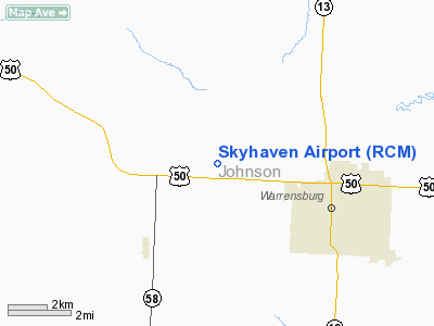
Skyhaven Airport (ICAO: KRCM, FAA LID: RCM) is a public-use airport located three miles (5 km) northwest of the central business district of Warrensburg, a city in Johnson County, Missouri, United States. It is owned by the University of Central Missouri.
Although most U.S. airports use the same three-letter location identifier for the FAA and IATA, Skyhaven Airport is assigned RCM by the FAA but has no designation from the IATA (which assigned RCM to Richmond Airport in Richmond, Queensland, Australia).
Facilities and aircraft
Skyhaven Airport covers an area of 402 acres (163 ha) which contains two asphalt paved runways: 18/36 measuring 4,206 x 75 ft (1,282 x 23 m) and 13/31 measuring 2,801 x 60 ft (854 x 18 m).
For the 12-month period ending September 30, 2005, the airport had 74,325 aircraft operations, an average of 203 per day: 99.6% general aviation, 0.4% air taxi and <0.1% military. At that time there were 46 aircraft based at this airport: 80% single-engine, 13% multi-engine and 7% glider.
The above content comes from Wikipedia and is published under free licenses – click here to read more.
Location & QuickFacts
| FAA Information Effective: | 2008-09-25 |
| Airport Identifier: | RCM |
| Airport Status: | Operational |
| Longitude/Latitude: | 093-48-10.3000W/38-47-03.0000N
-93.802861/38.784167 (Estimated) |
| Elevation: | 798 ft / 243.23 m (Surveyed) |
| Land: | 402 acres |
| From nearest city: | 3 nautical miles NW of Warrensburg, MO |
| Location: | Johnson County, MO |
| Magnetic Variation: | 07E (1965) |
Owner & Manager
| Ownership: | Publicly owned |
| Owner: | Univ. Of Central Missouri |
| Address: | T.r. Gaines, Bldg 210
Warrensburg, MO 64093 |
| Phone number: | 816-543-4921 |
| Manager: | Bart Brown |
| Address: | T. R. Gaines, Bldg 210
Warrensburg, MO 64093 |
| Phone number: | 816-543-4921 |
Airport Operations and Facilities
| Airport Use: | Open to public |
| Wind indicator: | Yes |
| Segmented Circle: | Yes |
| Control Tower: | No |
| Lighting Schedule: | DUSK-DAWN
ACTVT MIRL RYS 13/31 & 18/36, PAPI RY 18, REILS RY 18, 36, 13, 31 - CTAF. PAPI RY 36 ON 24 HRS. |
| Beacon Color: | Clear-Green (lighted land airport) |
| Landing fee charge: | No |
| Sectional chart: | Kansas City |
| Region: | ACE - Central |
| Boundary ARTCC: | ZKC - Kansas City |
| Tie-in FSS: | COU - Columbia |
| FSS on Airport: | No |
| FSS Toll Free: | 1-800-WX-BRIEF |
| NOTAMs Facility: | COU (NOTAM-d service avaliable) |
| Federal Agreements: | NGY |
Airport Communications
| CTAF: | 123.000 |
| Unicom: | 123.000 |
Airport Services
| Fuel available: | 100LLA |
| Airframe Repair: | MINOR |
| Power Plant Repair: | MINOR |
| Bottled Oxygen: | NONE |
| Bulk Oxygen: | NONE |
Runway Information
Runway 13/31
| Dimension: | 2801 x 60 ft / 853.7 x 18.3 m |
| Surface: | ASPH, Fair Condition |
| Weight Limit: | Single wheel: 12500 lbs. |
| Edge Lights: | Medium |
| |
Runway 13 |
Runway 31 |
| Longitude: | 093-48-24.4274W | 093-48-00.3920W |
| Latitude: | 38-47-02.5324N | 38-46-42.2210N |
| Elevation: | 798.00 ft | 786.00 ft |
| Alignment: | 127 | 127 |
| Traffic Pattern: | Right | Left |
| Markings: | Basic, Poor Condition
MARKINGS FADING. | Basic, Fair Condition |
| Runway End Identifier: | Yes | Yes |
| Obstruction: | 20 ft trees, 815.0 ft from runway, 85 ft left of centerline, 30:1 slope to clear | 15 ft road, 375.0 ft from runway, 11:1 slope to clear |
|
Runway 18/36
| Dimension: | 4206 x 75 ft / 1282.0 x 22.9 m |
| Surface: | ASPH, Good Condition |
| Weight Limit: | Single wheel: 21000 lbs.
Dual wheel: 26000 lbs. |
| Edge Lights: | Medium |
| |
Runway 18 |
Runway 36 |
| Longitude: | 093-48-05.1073W | 093-48-12.6022W |
| Latitude: | 38-47-30.6780N | 38-46-49.5221N |
| Elevation: | 796.00 ft | 789.00 ft |
| Alignment: | 127 | 8 |
| Traffic Pattern: | Right | Left |
| Markings: | Non-precision instrument, Good Condition | Non-precision instrument, Fair Condition |
| Crossing Height: | 40.00 ft | 36.00 ft |
| VASI: | 4-light PAPI on right side | 4-light PAPI on left side |
| Visual Glide Angle: | 3.00° | 3.00° |
| Runway End Identifier: | Yes | Yes |
| Obstruction: | 27 ft trees, 1500.0 ft from runway, 48:1 slope to clear | 33 ft tree, 730.0 ft from runway, 263 ft left of centerline, 16:1 slope to clear |
|
Radio Navigation Aids
| ID |
Type |
Name |
Ch |
Freq |
Var |
Dist |
| HCK | NDB | Hawks | | 296.00 | 04E | 14.3 nm |
| GLY | NDB | Golden Valley | | 388.00 | 04E | 26.2 nm |
| LXT | NDB | Lesumit | | 263.00 | 04E | 28.7 nm |
| DMO | NDB | Sedalia | | 281.00 | 03E | 29.7 nm |
| PUR | NDB | Marshall | | 371.00 | 03E | 32.4 nm |
| GPH | NDB | Mosby | | 284.00 | 03E | 41.2 nm |
| GKB | NDB | Norge | | 517.00 | 05E | 43.2 nm |
| GQ | NDB | Norge | | 517.00 | 05E | 43.2 nm |
| SZL | TACAN | Whiteman | 035X | | 04E | 12.2 nm |
| RIS | VOR/DME | Riverside | 051X | 111.40 | 05E | 42.2 nm |
| OJC | VOR/DME | Johnson County | 077X | 113.00 | 06E | 43.9 nm |
| ANX | VORTAC | Napoleon | 087X | 114.00 | 07E | 24.1 nm |
| BUM | VORTAC | Butler | 106X | 115.90 | 07E | 44.6 nm |
| MKC | VOT | Kansas City Downtown | | 108.60 | | 42.4 nm |
Remarks
- PVT GLIDER OPNS CONDUCTED AT ARPT.
- SOUTH 100 FT OF APRON & EXIT RAMP LCTD 1250 FT N OF RY 36 THLD HAS SAME PAVEMENT STRENGTH AS RY 18/36; REMAINDER OF APRON NOT FULL STRENGTH.
- LIMITED SIGHT DSTC FM RY 13 THLD AREA TO RY 18 THLD AND FM RY 18 THLD TO RY 31 THLD AREA.
- WILDLIFE ON & INVOF ARPT.
- CALM WIND RY 36.
Images and information placed above are from
http://www.airport-data.com/airport/RCM/
We thank them for the data!
| General Info
|
| Country |
United States
|
| State |
MISSOURI
|
| FAA ID |
RCM
|
| Latitude |
38-47-03.273N
|
| Longitude |
093-48-10.275W
|
| Elevation |
795 feet
|
| Near City |
WARRENSBURG
|
We don't guarantee the information is fresh and accurate. The data may
be wrong or outdated.
For more up-to-date information please refer to other sources.
|
|


