|
|
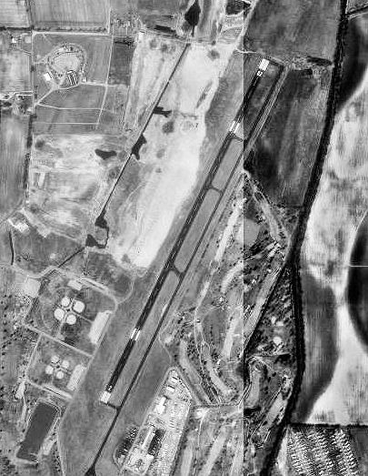
Sikeston Memorial Municipal Airport |
| Sikeston Memorial Municipal Airport |
 |
| 1996 USGS airphotos |
| IATA: SIK – ICAO: KSIK – FAA LID: SIK |
| Summary |
| Airport type |
Public |
| Owner |
City of Sikeston |
| Serves |
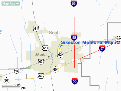
Sikeston, Missouri |
| Elevation AMSL |
315 ft / 96 m |
| Coordinates |
36°53′56″N 089°33′42″W / 36.89889°N 89.56167°W / 36.89889; -89.56167 |
| Runways |
| Direction |
Length |
Surface |
| ft |
m |
| 2/20 |
5,502 |
1,677 |
Asphalt |
| Statistics (2006) |
| Aircraft operations |
10,400 |
| Based aircraft |
14 |
| Source: Federal Aviation Administration |
Sikeston Memorial Municipal Airport (IATA: SIK, ICAO: KSIK, FAA LID: SIK) is a city-owned public-use airport located in Scott County, Missouri, United States. The airport is two nautical miles (3.7 km) northeast of the central business district of the city of Sikeston. Facilities and aircraft
Sikeston Memorial Municipal Airport covers an area of 732 acres (296 ha) at an elevation of 315 feet (96 m) above mean sea level. It has one asphalt paved runway designated 2/20 which measures 5,502 by 100 feet (1,677 x 30 m).
For the 12-month period ending August 31, 2006, the airport had 10,400 aircraft operations, an average of 28 per day: 83% general aviation, 10% military and 8% air taxi. At that time there were 14 aircraft based at this airport: 64% single-engine, 14% multi-engine and 21% ultralight.
History
Opened in April 1940 as Harvey Parks Airport with 6,600' x 5,280' open turf field. Began training United States Army Air Corps flying cadets in June 1940 under contract to Missouri Institute of Aeronautics. Assigned to United States Army Air Forces Gulf Coast Training Center (later Central FLying Training Command) as a primary (level 1) pilot training airfield. Flying training was performed with Fairchild PT-19s as the primary trainer. Also had several PT-17 Stearmans and a few P-40 Warhawks assigned. Also provided flexible gunnery training.
Inactivated on 16 October 1944 with the drawdown of AAFTC's pilot training program. Declared surplus and turned over to the Army Corps of Engineers on 30 September 1945. Eventually discharged to the War Assets Administration (WAA) and returned to being a civil airport.
The above content comes from Wikipedia and is published under free licenses – click here to read more.
Location & QuickFacts
| FAA Information Effective: | 2008-09-25 |
| Airport Identifier: | SIK |
| Airport Status: | Operational |
| Longitude/Latitude: | 089-33-42.3000W/36-53-56.0000N
-89.561750/36.898889 (Estimated) |
| Elevation: | 315 ft / 96.01 m (Surveyed) |
| Land: | 732 acres |
| From nearest city: | 2 nautical miles NE of Sikeston, MO |
| Location: | Scott County, MO |
| Magnetic Variation: | 01E (1990) |
Owner & Manager
| Ownership: | Publicly owned |
| Owner: | City Of Sikeston |
| Address: | 105 E Center
Sikeston, MO 63801 |
| Phone number: | 573-471-2512 |
| Manager: | Sikeston Aviation |
| Address: | 160 Airport Dr
Sikeston, MO 63801 |
| Phone number: | 573-471-9056 |
Airport Operations and Facilities
| Airport Use: | Open to public |
| Wind indicator: | Yes |
| Segmented Circle: | Yes |
| Control Tower: | No |
| Lighting Schedule: | DUSK-DAWN
MIRL RY 02/20 PRESET ON LOW INTST; TO INCR INTST AND ACTVT REIL RY 20 - CTAF. VASI RWY 02 & 20 ON 24 HRS. |
| Beacon Color: | Clear-Green (lighted land airport) |
| Landing fee charge: | No |
| Sectional chart: | St Louis |
| Region: | ACE - Central |
| Boundary ARTCC: | ZME - Memphis |
| Tie-in FSS: | STL - Saint Louis |
| FSS on Airport: | No |
| FSS Toll Free: | 1-800-WX-BRIEF |
| NOTAMs Facility: | STL (NOTAM-d service avaliable) |
| Federal Agreements: | NGPY |
Airport Communications
| CTAF: | 122.800 |
| Unicom: | 122.800 |
Airport Services
| Fuel available: | 100LLA
24-HR AUTOMATIC CREDIT CARD FUELING SYSTEM FOR 100LL. |
| Bottled Oxygen: | NONE |
| Bulk Oxygen: | NONE |
Runway Information
Runway 02/20
| Dimension: | 5502 x 100 ft / 1677.0 x 30.5 m |
| Surface: | ASPH, Poor Condition
RWY 02/20 HAS CRACKS WITH GRASS GROWING IN THEM.
RY 02/20 AND PARALLEL TWY HAS NUMEROUS CRACKS. |
| Weight Limit: | Single wheel: 30000 lbs.
Dual wheel: 38000 lbs. |
| Edge Lights: | Non-standard lighting system
NSTD MIRL; THLD LGTS SPACING INCORRECT. |
| |
Runway 02 |
Runway 20 |
| Longitude: | 089-33-56.0561W | 089-33-28.5445W |
| Latitude: | 36-53-31.1052N | 36-54-20.8177N |
| Elevation: | 313.00 ft | 314.00 ft |
| Alignment: | 24 | 127 |
| Traffic Pattern: | Left | Left |
| Markings: | Non-precision instrument, Poor Condition
MARKINGS FADED. | Non-precision instrument, Poor Condition
MARKINGS FADED. |
| Crossing Height: | 25.00 ft | 27.00 ft |
| VASI: | 2-box on left side | 2-box on left side |
| Visual Glide Angle: | 3.00° | 3.00° |
| Runway End Identifier: | | Yes |
| Obstruction: | 65 ft trees, 3420.0 ft from runway, 440 ft left of centerline, 49:1 slope to clear | , 50:1 slope to clear |
|
Radio Navigation Aids
| ID |
Type |
Name |
Ch |
Freq |
Var |
Dist |
| CHQ | NDB | Charleston | | 208.00 | 01E | 10.4 nm |
| CIR | NDB | Cairo | | 397.00 | 00E | 19.0 nm |
| DXE | NDB | Dexter | | 423.00 | 00E | 19.4 nm |
| FD | NDB | Earli | | 278.00 | 03E | 39.4 nm |
| BDD | NDB | Bellgrade | | 254.00 | 00E | 45.3 nm |
| UC | NDB | Obion | | 212.00 | 00E | 45.3 nm |
| TKX | NDB | Kennett | | 358.00 | 00E | 46.4 nm |
| GGK | NDB | Mayfield | | 401.00 | 00E | 48.3 nm |
| CGI | VOR/DME | Cape Girardeau | 076X | 112.90 | 01E | 19.8 nm |
| MAW | VORTAC | Malden | 049X | 111.20 | 03E | 26.7 nm |
| CNG | VORTAC | Cunningham | 078X | 113.10 | 03E | 35.4 nm |
Remarks
- NUMEROUS BIRDS INVOF ARPT.
Images and information placed above are from
http://www.airport-data.com/airport/SIK/
We thank them for the data!
| General Info
|
| Country |
United States
|
| State |
MISSOURI
|
| FAA ID |
SIK
|
| Latitude |
36-53-56.000N
|
| Longitude |
089-33-42.300W
|
| Elevation |
315 feet
|
| Near City |
SIKESTON
|
We don't guarantee the information is fresh and accurate. The data may
be wrong or outdated.
For more up-to-date information please refer to other sources.
|
|