 |
|
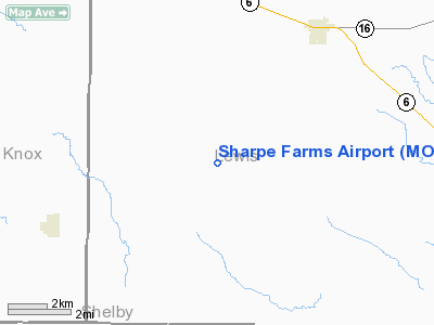
Location & QuickFacts
| FAA Information Effective: | 2008-09-25 |
| Airport Identifier: | MO09 |
| Airport Status: | Operational |
| Longitude/Latitude: | 091-52-25.6080W/40-01-25.1520N
-91.873780/40.023653 (Estimated) |
| Elevation: | 702 ft / 213.97 m (Estimated) |
| Land: | 30 acres |
| From nearest city: | 4 nautical miles NE of Lewistown, MO |
| Location: | Lewis County, MO |
| Magnetic Variation: | 03E (1985) |
Owner & Manager
| Ownership: | Privately owned |
| Owner: | C.n. Sharpe Jr. |
| Address: | 500e 9th
Kansas City, MO 64106 |
| Phone number: | 816-842-6300 |
| Manager: | George Feuerborn
CTC PERSON (PILOT) |
| Address: | Exec Beech-downtown Arpt
Kansas City, MO 64116 |
| Phone number: | 816-842-8484 |
Airport Operations and Facilities
| Airport Use: | Private |
| Wind indicator: | Yes |
| Segmented Circle: | No |
| Control Tower: | No |
| Lighting Schedule: | PHONE REQ
FOR NSTD LIRL RY 13/31 CALL 816-842-8484. |
| Landing fee charge: | No |
| Sectional chart: | Chicago |
| Region: | ACE - Central |
| Boundary ARTCC: | ZKC - Kansas City |
| Tie-in FSS: | STL - Saint Louis |
| FSS on Airport: | No |
| FSS Toll Free: | 1-800-WX-BRIEF |
Airport Services
| Airframe Repair: | NONE |
| Power Plant Repair: | NONE |
| Bottled Oxygen: | NONE |
| Bulk Oxygen: | NONE |
Runway Information
Runway 13/31
| Dimension: | 3235 x 40 ft / 986.0 x 12.2 m |
| Surface: | ASPH, Good Condition |
| Edge Lights: | Non-standard lighting system
NSTD LGTS - SPACING 100' - NOT PERPENDICULAR TO EACH OTHER. |
| |
Runway 13 |
Runway 31 |
| Traffic Pattern: | Left | Left |
| Obstruction: | 7 ft pline, 340.0 ft from runway, 48:1 slope to clear | , 50:1 slope to clear |
|
Radio Navigation Aids
| ID |
Type |
Name |
Ch |
Freq |
Var |
Dist |
| HAE | NDB | Hannibal | | 411.00 | 03E | 26.5 nm |
| UI | NDB | Quincy | | 293.00 | 02E | 29.7 nm |
| EOK | NDB | Keokuk | | 366.00 | 02E | 33.3 nm |
| MCM | VOR/DME | Macon | 076X | 112.90 | 06E | 35.8 nm |
| UIN | VORTAC | Quincy | 083X | 113.60 | 05E | 29.4 nm |
| IRK | VORTAC | Kirksville | 093X | 114.60 | 06E | 33.7 nm |
Remarks
- FCS, HIGH GND, RD, BLDG, P-P0LE, BRUSH, TIE DOWN AREA & TWY IN PRIM SFC.
Images and information placed above are from
http://www.airport-data.com/airport/MO09/
We thank them for the data!
| General Info
|
| Country |
United States
|
| State |
MISSOURI
|
| FAA ID |
MO09
|
| Latitude |
40-01-25.152N
|
| Longitude |
091-52-25.608W
|
| Elevation |
702 feet
|
| Near City |
LEWISTOWN
|
We don't guarantee the information is fresh and accurate. The data may
be wrong or outdated.
For more up-to-date information please refer to other sources.
|
|


