 |
|
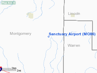
Location & QuickFacts
| FAA Information Effective: | 2008-09-25 |
| Airport Identifier: | MO86 |
| Airport Status: | Operational |
| Longitude/Latitude: | 091-18-14.0000W/38-57-35.0000N
-91.303889/38.959722 (Estimated) |
| Elevation: | 750 ft / 228.60 m (Estimated) |
| Land: | 0 acres |
| From nearest city: | 4 nautical miles NW of Bellflower, MO |
| Location: | Montgomery County, MO |
| Magnetic Variation: | 02E (1995) |
Owner & Manager
| Ownership: | Privately owned |
| Owner: | Gary Handlang |
| Address: | 55 Loveland Lane
Truxton, MO 63381 |
| Phone number: | 314-488-5905 |
| Manager: | Gary Handlang |
| Address: | 55 Loveland Lane
Truxton, MO 63381 |
| Phone number: | 314-488-5905 |
Airport Operations and Facilities
| Airport Use: | Private |
| Wind indicator: | Yes |
| Segmented Circle: | No |
| Control Tower: | No |
| Landing fee charge: | No |
| Sectional chart: | Kansas City |
| Region: | ACE - Central |
| Boundary ARTCC: | ZKC - Kansas City |
| Tie-in FSS: | COU - Columbia |
| FSS on Airport: | No |
| FSS Toll Free: | 1-800-WX-BRIEF |
Runway Information
Runway 09/27
| Dimension: | 1400 x 80 ft / 426.7 x 24.4 m |
| Surface: | TURF, |
| |
Runway 09 |
Runway 27 |
| Traffic Pattern: | Left | Left |
| Displaced threshold: | 0.00 ft | 200.00 ft |
| Obstruction: | | 40 ft trees |
|
Radio Navigation Aids
| ID |
Type |
Name |
Ch |
Freq |
Var |
Dist |
| FTT | NDB | Guthrie | | 317.00 | 03E | 33.5 nm |
| LM | NDB | Oblio | | 338.00 | 00E | 40.0 nm |
| JE | NDB | Algoa | | 397.00 | 03E | 43.7 nm |
| UUV | NDB | Sullivan | | 356.00 | 02E | 44.0 nm |
| HAE | NDB | Hannibal | | 411.00 | 03E | 46.6 nm |
| PPQ | NDB | Pittsfield | | 344.00 | 02E | 47.6 nm |
| ONH | NDB | Noah | | 515.00 | 03E | 48.2 nm |
| COU | VOR/DME | Columbia | 039X | 110.20 | 03E | 43.7 nm |
| CSX | VOR/DME | Cardinal | 111Y | 116.45 | 00E | 45.9 nm |
| FTZ | VORTAC | Foristell | 045X | 110.80 | 05E | 22.3 nm |
| STL | VORTAC | St Louis | 121X | 117.40 | 01E | 38.9 nm |
| HLV | VORTAC | Hallsville | 089X | 114.20 | 06E | 39.6 nm |
| SUS | VOT | Spirit Of St Louis | | 112.20 | | 35.4 nm |
| JEF | VOT | Jefferson City | | 112.00 | | 45.4 nm |
| STL | VOT | St Louis Lambert | | 111.00 | | 45.9 nm |
Remarks
- OWNER DESIRES ARPT NOT BE CHARTED.
- PRVDD MAINTAIN CLEAR 20:1 APCH TO RY END & MAINTAIN CLEAR 2:1 TRANSITIONAL SURFACE.
Images and information placed above are from
http://www.airport-data.com/airport/MO86/
We thank them for the data!
| General Info
|
| Country |
United States
|
| State |
MISSOURI
|
| FAA ID |
MO86
|
| Latitude |
38-57-35.000N
|
| Longitude |
091-18-14.000W
|
| Elevation |
750 feet
|
| Near City |
BELLFLOWER
|
We don't guarantee the information is fresh and accurate. The data may
be wrong or outdated.
For more up-to-date information please refer to other sources.
|
|


