 |
|
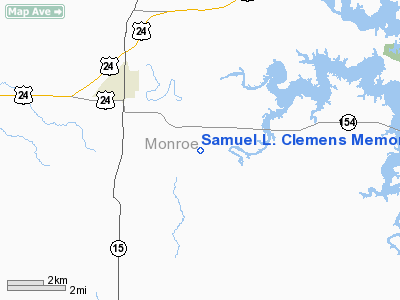
Samuel L. Clemens Memorial Airport |
Location & QuickFacts
| FAA Information Effective: | 2008-09-25 |
| Airport Identifier: | MU00 |
| Airport Status: | Operational |
| Longitude/Latitude: | 091-57-06.6070W/39-26-40.1410N
-91.951835/39.444484 (Estimated) |
| Elevation: | 730 ft / 222.50 m (Estimated) |
| Land: | 0 acres |
| From nearest city: | 3 nautical miles SE of Paris, MO |
| Location: | Monroe County, MO |
| Magnetic Variation: | 03E (1985) |
Owner & Manager
| Ownership: | Privately owned |
| Owner: | Jim Primm |
| Address: | Rt 2, Box 218
Paris, MO 65275 |
| Phone number: | 816-327-5576 |
| Manager: | Jim Primm |
| Address: | Rt 2, Box 218
Paris, MO 65275 |
| Phone number: | 816-327-5576 |
Airport Operations and Facilities
| Airport Use: | Private |
| Wind indicator: | Yes |
| Segmented Circle: | No |
| Control Tower: | No |
| Landing fee charge: | No |
| Sectional chart: | Kansas City |
| Region: | ACE - Central |
| Boundary ARTCC: | ZKC - Kansas City |
| Tie-in FSS: | STL - Saint Louis |
| FSS on Airport: | No |
| FSS Toll Free: | 1-800-WX-BRIEF |
Airport Services
| Airframe Repair: | NONE |
| Power Plant Repair: | NONE |
| Bottled Oxygen: | NONE |
| Bulk Oxygen: | NONE |
Runway Information
Runway N/S
| Dimension: | 2000 x 50 ft / 609.6 x 15.2 m |
| Surface: | TURF, |
| |
Runway N |
Runway S |
| Traffic Pattern: | Left | Left |
| Runway End Identifier: | No | No |
| Centerline Lights: | No | No |
| Touchdown Lights: | No | No |
| Obstruction: | 20 ft pline, 200.0 ft from runway | 20 ft tree |
|
Radio Navigation Aids
| ID |
Type |
Name |
Ch |
Freq |
Var |
Dist |
| HAE | NDB | Hannibal | | 411.00 | 03E | 28.9 nm |
| FTT | NDB | Guthrie | | 317.00 | 03E | 36.2 nm |
| UI | NDB | Quincy | | 293.00 | 02E | 41.8 nm |
| VER | NDB | Viertel | | 347.00 | 02E | 45.3 nm |
| MCM | VOR/DME | Macon | 076X | 112.90 | 06E | 27.6 nm |
| COU | VOR/DME | Columbia | 039X | 110.20 | 03E | 40.1 nm |
| HLV | VORTAC | Hallsville | 089X | 114.20 | 06E | 21.5 nm |
| UIN | VORTAC | Quincy | 083X | 113.60 | 05E | 39.5 nm |
Remarks
- E111 PRVDD THE APCH TO EACH RWY IS MAINTD FOR A MIN 20:1 GLIDE SLOPE AND THE TRANSITIONAL SFC BE MAINTD FOR A 7:1 SLOPE.
Images and information placed above are from
http://www.airport-data.com/airport/MU00/
We thank them for the data!
| General Info
|
| Country |
United States
|
| State |
MISSOURI
|
| FAA ID |
MU00
|
| Latitude |
39-26-40.141N
|
| Longitude |
091-57-06.607W
|
| Elevation |
730 feet
|
| Near City |
PARIS
|
We don't guarantee the information is fresh and accurate. The data may
be wrong or outdated.
For more up-to-date information please refer to other sources.
|
|


