|
 |
|
||||
|
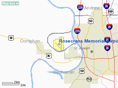
Rosecrans Memorial Airport (IATA: STJ, ICAO: KSTJ) is a joint civil-military public airport located three miles (5 km) northwest of the city of St. Joseph in Buchanan County, Missouri, USA. The airport is one of two bases for the Missouri Air National Guard and also serves general aviation. History
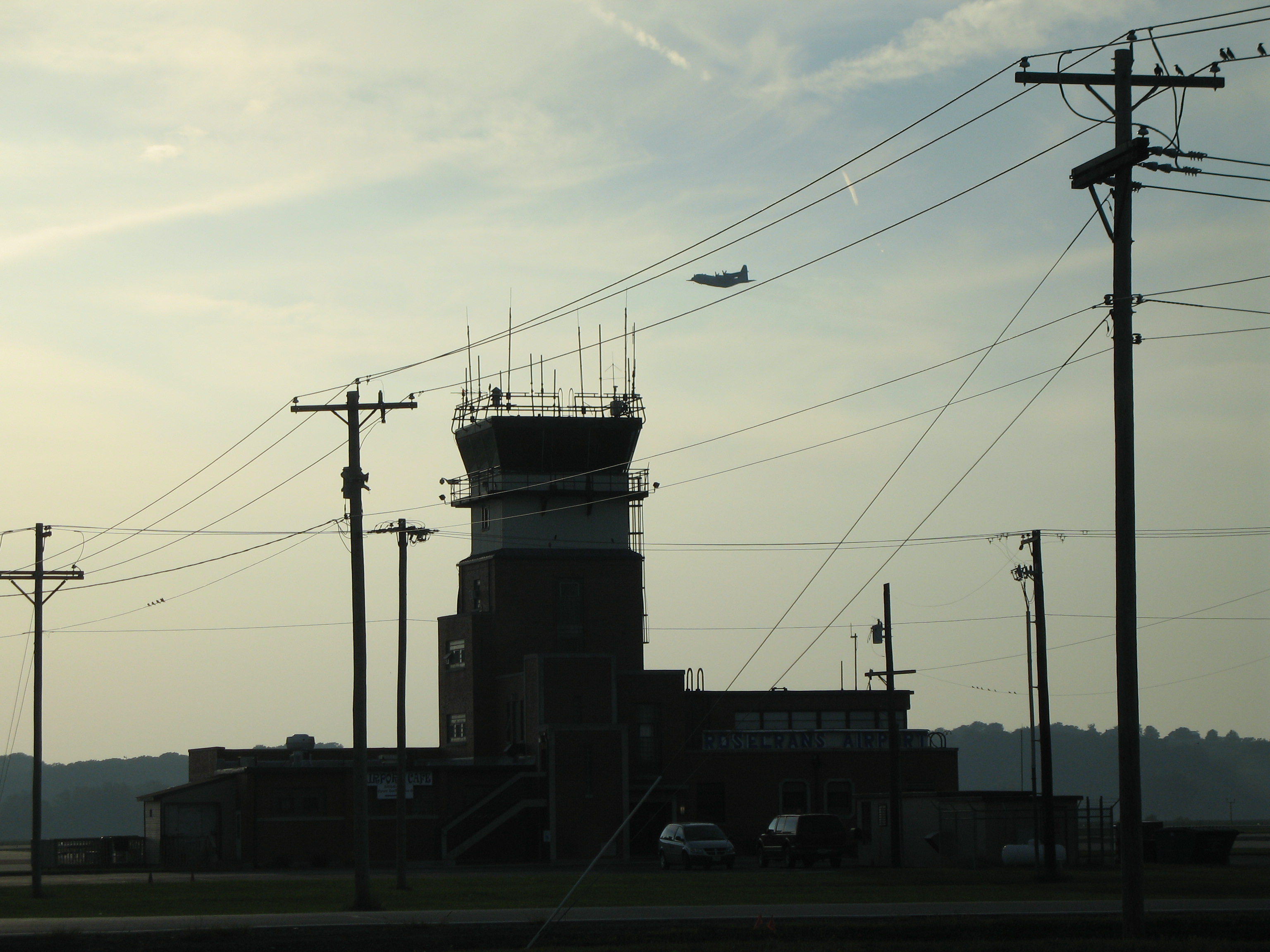
Rosecrans Memorial Airport is located on a field that was once referred to as the French Bottoms. It was surrounded by four towns, three of which existed as late as 1979. The northern portion of the French Bottoms was settled first, in the 1830s-50's, and has since washed away. The settlers were French-born and/or descendants of earlier French settlers. In 1877 most of the land that now comprises the airport was located on a river bank on what was called "made land." This land had been formed by river deposits. By this year the French Bottoms contained sixty houses, one church, and two schools. The rich river bottom land, totaling approximately five thousand acres (20 km²), was traditionally used for farming. Some of the descendants of the early French settlers still lived in the bottoms in 1939, when the area was razed to make way for the airport. The airport was named in honor of Sgt Guy Wallace Rosecrans "and comrades" of the 153rd Aero Squadron, U.S. Army Air Service, 1917-18. Rosecrans was the only St. Joseph airman killed in World War I. The new 1939 flying field was the third airport in St. Joseph to bear the name Rosecrans. In 1922 the first Rosecrans Field was opened at Lake Contrary. The second was Rosecrans Municipal Airport on the waterworks road, abandoned because of its small size and its dangerous proximity to the Missouri River bluffs to its east. The 1939 airport was developed by the city as a municipal airport. Two three-thousand-foot-long (910 m) runways were constructed in 1939, as well as an aircraft hangar located east of the runway intersection. During World War II the federal government established an Army Air Forces base at Rosecrans with numerous improvements being made between 1942 and 1943. The diagonal runways were doubled in length and a 5,500-foot (1,700 m) north-south runway was constructed, while the aircraft parking apron and many temporary buildings, including Hangar T-1020, were built. In 1948 much of the airfield's facilities were conveyed to the city, with the exception of 142 acres (0.57 km) set aside for use by the Air National Guard. Airport construction during this period consisted of pump house buildings and T-hangars (1949–50) and a terminal and administration building (1951–52). The Great Flood of 1951 damaged many of the temporary World War II airport buildings beyond economical repair. The Missouri River changed course in the flood, cutting off the airport from its land connection to St. Joseph. Today, visitors from Missouri must go through Kansas via the Pony Express Bridge and Elwood, Kansas in order to reach the airport. The U.S. Army Corps of Engineers formalized the course change by dredging cut-off channel for the river between the airport and downtown St. Joseph. An oxbow lake (Browning Lake) was formed in the old Bellemont Bend and Elwood Bend portions of the river channel. The cut-off channel modified portions of Bon Ton Bend and St. Joseph Bend, and separated the city from the airport. A bridge and highway were later constructed to connect the two. Construction during the next twenty years included a main hangar building (1954), a flight office building (1960), an emergency generator building (1963), a center taxiway (1973), and a runway (1974–75). The Great Flood of 1993 destroyed the City Administration Building and the Cockpit Cafe. Both were rebuilt. The oldest, center hangar had to be demolished. In 1994, the diagonal runway, Runway 13-31, was rebuilt into a new assault landing strip for the Air National Guard and as an additional VFR runway for general aviation aircraft. A new fixed base operator building and a hangar were also constructed. The last scheduled commercial airline service at the airport was in 1969, three years before the opening of Kansas City International Airport, 30 miles (48 km) south of downtown St. Joseph via Interstate 29. Over the years the airport has been used for/by business-related general aviation, agricultural crop spraying, charter passenger and cargo services, area student pilot training, nightly mail delivery, and until its acquisition by American Airlines, pilot training operations by Trans World Airlines (TWA). Today, its primary use is as a base for the Missouri Air National Guard. Rosecrans Air National Guard BaseAs previously mentioned, with the end of World War II, much of the former U.S. Army Air Forces installation was transferred to the city with the exception of 142 acres (0.57 km) for the National Guard. With the establishment of an independent U.S. Air Force in 1947, the military facilities became part of the newly-established Air National Guard. This facility became the foundation for the current Rosecrans Air National Guard Base. Rosecrans ANGB is currently home to the 139th Airlift Wing (139 AW), an Air Mobility Command (AMC)-gained unit of the Missouri Air National Guard, which functions as the host wing for the installation. The An additional tenant command at Rosecrans ANGB is the Advanced Airlift Tactics Training Center (AATTC), a combined activity of both the Air National Guard (ANG) and the Air Force Reserve Command (AFRC). The mission of the Advanced Airlift Tactics Training Center (AATTC) is to increase the warfighting effectiveness and survivability of all USAF air mobility forces. AATTC is made up of full-time Air National Guard and Air Force Reserve personnel dedicated to increasing the warfighting effectiveness and survivability of air mobility forces, providing advanced tactics training to tactical airlift crews and support personnel from the Air National Guard, Air Force Reserve Command, Air Mobility Command, Air Combat Command, Air Force Special Operations Command, the United States Marine Corps, and twelve Allied nations. The AATTC functions as a clearinghouse for gathering and disseminating airlift tactics information. Since 1983 the AATTC has hosted an annual Tactics Symposium at Rosecrans ANGB as a forum for providing crosstalk across the tactics community. Both the 139 AW and the AATTC are made up of a mix of approximately 400 full-time Active Guard and Reserve (AGR) and Air Reserve Technician (ART) personnel, augmented by over 1000 traditional part-time The above content comes from Wikipedia and is published under free licenses – click here to read more.
Location & QuickFacts
Owner & Manager
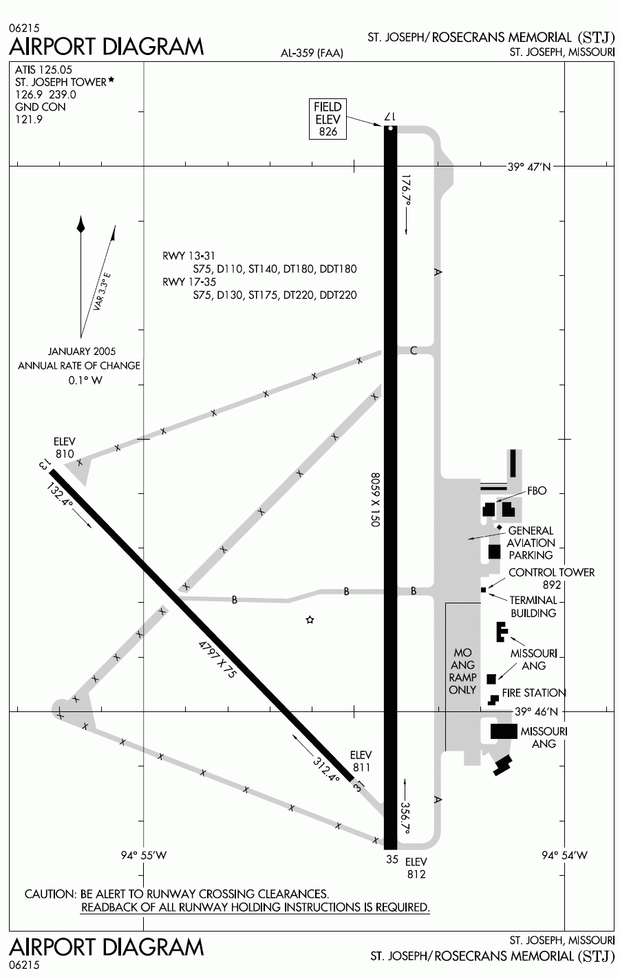
Airport Operations and Facilities
Airport Communications
Airport Services
Runway InformationRunway 13/31
Runway 17/35
Radio Navigation Aids
Remarks
Images and information placed above are from We thank them for the data!
We don't guarantee the information is fresh and accurate. The data may
be wrong or outdated.
|
||||||||||||||||||||||||||||||||||||||||||||||||||||||||||||||||||||||||||||||||||||||||||||||||||||||||||||||||||||||||||||||||||||||||||||||||||||||||||||||||||||||||||||||||||||||||||||||||||||||||||||||||||||||||||||||||||||||||||||||||||||||||||||||||||||||||||||||||||||||||||||||||||||||||||||||||||||||||||||||||||||||||||||||||||||||||||||||||||||||||||||||||||||||

 |
|
Copyright 2004-2026 © by Airports-Worldwide.com, Vyshenskoho st. 36, Lviv 79010, Ukraine Legal Disclaimer |