 |
|
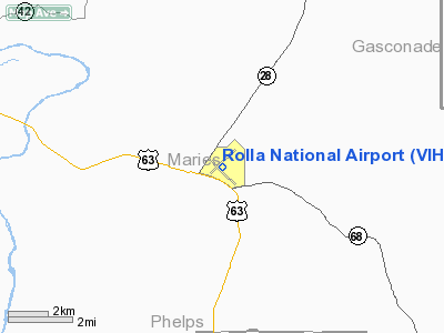
Location & QuickFacts
| FAA Information Effective: | 2008-09-25 |
| Airport Identifier: | VIH |
| Airport Status: | Operational |
| Longitude/Latitude: | 091-46-10.2000W/38-07-38.7000N
-91.769500/38.127417 (Estimated) |
| Elevation: | 1148 ft / 349.91 m (Surveyed) |
| Land: | 1370 acres |
| From nearest city: | 11 nautical miles N of Rolla/vichy, MO |
| Location: | Maries County, MO |
| Magnetic Variation: | 02E (2000) |
Owner & Manager
| Ownership: | Publicly owned |
| Owner: | City Of Rolla |
| Address: | 102 W 9th St Box 979
Rolla, MO 65402 |
| Phone number: | 573-426-6940 |
| Manager: | Wesley Faulkner
AIRPORT SUPERVISOR. |
| Address: | Po Box 505
Vichy, MO 65580 |
| Phone number: | 573-299-4498 |
Airport Operations and Facilities
| Airport Use: | Open to public |
| Wind indicator: | Yes |
| Segmented Circle: | No |
| Control Tower: | No |
| Lighting Schedule: | DUSK-DAWN
ACTVT HIRL RY 04/22; MIRL RY 13/31; VASI RYS 04 & 22 - CTAF. |
| Beacon Color: | Clear-Green (lighted land airport) |
| Landing fee charge: | No |
| Sectional chart: | Kansas City |
| Region: | ACE - Central |
| Boundary ARTCC: | ZKC - Kansas City |
| Tie-in FSS: | COU - Columbia |
| FSS Toll Free: | 1-800-WX-BRIEF |
| NOTAMs Facility: | COU (NOTAM-d service avaliable) |
| Federal Agreements: | NGSXY |
Airport Communications
| CTAF: | 123.000 |
| Unicom: | 123.000 |
Airport Services
| Fuel available: | 100LLA |
| Airframe Repair: | MINOR
AIRFRAME & POWER PLANT REAPRS EMERGENCY ONLY. |
| Power Plant Repair: | MINOR |
| Bottled Oxygen: | NONE |
| Bulk Oxygen: | NONE |
Runway Information
Runway 04/22
| Dimension: | 5500 x 100 ft / 1676.4 x 30.5 m |
| Surface: | ASPH, Good Condition |
| Weight Limit: | Single wheel: 75000 lbs.
Dual wheel: 85000 lbs.
Dual tandem wheel: 130000 lbs. |
| Edge Lights: | Non-standard lighting system
NSTD HIRL; LGTS ARE 34 FT FROM PAVEMENT EDGE. |
| |
Runway 04 |
Runway 22 |
| Longitude: | 091-46-35.9862W | 091-45-46.0028W |
| Latitude: | 38-07-29.3022N | 38-08-06.6826N |
| Elevation: | 1137.00 ft | 1109.00 ft |
| Alignment: | 47 | 127 |
| Traffic Pattern: | Left | Left |
| Markings: | Non-precision instrument, Good Condition
RWY 4 MARKINGS FADED. | Non-precision instrument, Good Condition
RWY 22 MARKINGS FADED. |
| Crossing Height: | 45.00 ft | 52.00 ft |
| Displaced threshold: | 213.00 ft | 0.00 ft |
| VASI: | 4-box on left side | 4-box on left side |
| Visual Glide Angle: | 3.00° | 3.00° |
| Runway End Identifier: | | No |
| Obstruction: | 22 ft road, 435.0 ft from runway, 270 ft right of centerline, 10:1 slope to clear
APCH RATIO 29:1; DSPLCD THLD 1 FT LOWER THAN RY END. | 7 ft tree, 495.0 ft from runway, 122 ft right of centerline, 42:1 slope to clear |
|
Runway 13/31
| Dimension: | 5500 x 100 ft / 1676.4 x 30.5 m |
| Surface: | ASPH, Fair Condition |
| Weight Limit: | Single wheel: 48000 lbs.
Dual wheel: 62000 lbs.
Dual tandem wheel: 92000 lbs. |
| Edge Lights: | Medium
NSTD HIRL; LGTS ARE 34 FT FROM PAVEMENT EDGE. |
| |
Runway 13 |
Runway 31 |
| Longitude: | 091-46-33.1750W | 091-45-45.8361W |
| Latitude: | 38-07-49.2329N | 38-07-09.7662N |
| Elevation: | 1137.00 ft | 1148.00 ft |
| Alignment: | 127 | 127 |
| Traffic Pattern: | Left | Left |
| Markings: | Basic, Poor Condition
RWY 13 MARKINGS FADED. | Basic, Poor Condition
RWY 31 MARKINGS FADED. |
| Obstruction: | 19 ft road, 566.0 ft from runway, 273 ft right of centerline, 19:1 slope to clear | 27 ft trees, 622.0 ft from runway, 215 ft left of centerline, 15:1 slope to clear |
|
Radio Navigation Aids
| ID |
Type |
Name |
Ch |
Freq |
Var |
Dist |
| UBX | NDB | Cuba | | 380.00 | 01E | 16.6 nm |
| JE | NDB | Algoa | | 397.00 | 03E | 29.0 nm |
| UUV | NDB | Sullivan | | 356.00 | 02E | 29.3 nm |
| BHN | NDB | Buckhorn | | 391.00 | 03E | 30.3 nm |
| AIZ | NDB | Kaiser | | 377.00 | 05E | 37.1 nm |
| ONH | NDB | Noah | | 515.00 | 03E | 37.9 nm |
| FTT | NDB | Guthrie | | 317.00 | 03E | 44.4 nm |
| TBN | VOR | Forney | | 110.00 | 03E | 29.0 nm |
| VIH | VOR/DME | Vichy | 124X | 117.70 | 06E | 3.4 nm |
| SHY | VOR/DME | Sunshine | 021X | 108.40 | 05E | 39.7 nm |
| COU | VOR/DME | Columbia | 039X | 110.20 | 03E | 46.2 nm |
| MAP | VORTAC | Maples | 081X | 113.40 | 06E | 32.3 nm |
| JEF | VOT | Jefferson City | | 112.00 | | 33.0 nm |
Remarks
- 97 FT TOWER LCTD 1800 FT NNE OF RY 13 THLD.
- CLSD RY 18/36 NOT TO BE USED AS TWY.
- RADIO CONTROLLED MODEL AIRPLANES INVOF ARPT.
- HELI PARKING ON SE CORNER OF APRON.
- WILDLIFE ON & INVOF ARPT.
Images and information placed above are from
http://www.airport-data.com/airport/VIH/
We thank them for the data!
| General Info
|
| Country |
United States
|
| State |
MISSOURI
|
| FAA ID |
VIH
|
| Latitude |
38-07-38.756N
|
| Longitude |
091-46-10.281W
|
| Elevation |
1148 feet
|
| Near City |
ROLLA/VICHY
|
We don't guarantee the information is fresh and accurate. The data may
be wrong or outdated.
For more up-to-date information please refer to other sources.
|
|


