 |
|
Location & QuickFacts
| FAA Information Effective: | 2008-09-25 |
| Airport Identifier: | 96MO |
| Airport Status: | Operational |
| Longitude/Latitude: | 090-09-25.3910W/38-51-47.1740N
-90.157053/38.863104 (Estimated) |
| Elevation: | 434 ft / 132.28 m (Estimated) |
| Land: | 0 acres |
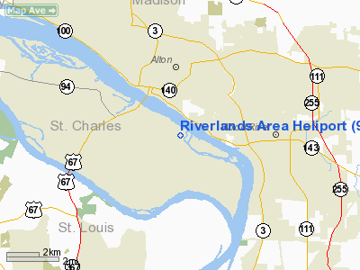
| From nearest city: | 4 nautical miles E of West Alton, MO |
| Location: | St Charles County, MO |
| Magnetic Variation: | 02E (1985) |
Owner & Manager
| Ownership: | Publicly owned |
| Owner: | Corps Of Engineers |
| Address: | P O Box 337
West Alton, MO 63386-0337 |
| Phone number: | 573-355-6505 |
| Manager: | Patrick Mc Ginnis |
| Address: | Po Box 337
West Alton, MO 63386 |
| Phone number: | 314-899-0405 |
Airport Operations and Facilities
| Airport Use: | Private |
| Segmented Circle: | No |
| Control Tower: | No |
| Landing fee charge: | No |
| Sectional chart: | Kansas City |
| Region: | ACE - Central |
| Boundary ARTCC: | ZKC - Kansas City |
| Tie-in FSS: | STL - Saint Louis |
| FSS on Airport: | No |
| FSS Toll Free: | 1-800-WX-BRIEF |
Runway Information
Helipad H1
| Dimension: | 100 x 100 ft / 30.5 x 30.5 m |
| Surface: | TURF, |
| |
Runway H1 |
Runway |
| Traffic Pattern: | Left | Left |
|
Radio Navigation Aids
| ID |
Type |
Name |
Ch |
Freq |
Var |
Dist |
| CVM | NDB | Civic Memorial | | 263.00 | 02E | 5.0 nm |
| LM | NDB | Oblio | | 338.00 | 00E | 15.3 nm |
| LTD | NDB | Litchfield | | 371.00 | 01E | 28.9 nm |
| BL | NDB | Belleville | | 362.00 | 02E | 30.4 nm |
| FES | NDB | Festus | | 269.00 | 01E | 41.5 nm |
| SAR | NDB | Sparta | | 239.00 | 01E | 48.2 nm |
| SKE | TACAN | Scott | 059X | | 02E | 23.9 nm |
| CSX | VOR/DME | Cardinal | 111Y | 116.45 | 00E | 11.6 nm |
| TOY | VORTAC | Troy | 107X | 116.00 | 04E | 13.4 nm |
| STL | VORTAC | St Louis | 121X | 117.40 | 01E | 15.2 nm |
| FTZ | VORTAC | Foristell | 045X | 110.80 | 05E | 39.5 nm |
| VLA | VORTAC | Vandalia | 090X | 114.30 | 04E | 48.5 nm |
| STL | VOT | St Louis Lambert | | 111.00 | | 11.8 nm |
| SUS | VOT | Spirit Of St Louis | | 112.20 | | 26.1 nm |
Remarks
- PROVIDED EGRESS/INGRESS PATHS ARE MAINTAINED FOR AN 8:1 GLIDE SLOPE AND TRANSITIONAL SURFACES FOR AMINIMUM 2:1 SLOPES.
Images and information placed above are from
http://www.airport-data.com/airport/96MO/
We thank them for the data!
| General Info
|
| Country |
United States
|
| State |
MISSOURI
|
| FAA ID |
96MO
|
| Latitude |
38-51-47.174N
|
| Longitude |
090-09-25.391W
|
| Elevation |
434 feet
|
| Near City |
WEST ALTON
|
We don't guarantee the information is fresh and accurate. The data may
be wrong or outdated.
For more up-to-date information please refer to other sources.
|
|


