 |
|
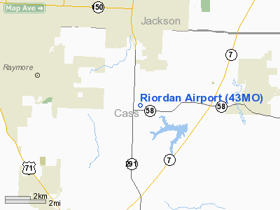
Location & QuickFacts
| FAA Information Effective: | 2008-09-25 |
| Airport Identifier: | 43MO |
| Airport Status: | Operational |
| Longitude/Latitude: | 094-22-05.8170W/38-47-00.0320N
-94.368282/38.783342 (Estimated) |
| Elevation: | 1000 ft / 304.80 m (Estimated) |
| Land: | 0 acres |
| From nearest city: | 5 nautical miles SW of Pleasant Hill, MO |
| Location: | Cass County, MO |
| Magnetic Variation: | 05E (1985) |
Owner & Manager
| Ownership: | Privately owned |
| Owner: | R. J. Riordan |
| Address: | Rt 5 Box 118
Pleasant Hill, MO 64080 |
| Phone number: | 816-524-1167 |
| Manager: | R. J. Riordan |
| Address: | Rt 5 Box 118
Pleasant Hill, MO 64080 |
| Phone number: | 816-421-6020 |
Airport Operations and Facilities
| Airport Use: | Private |
| Wind indicator: | Yes |
| Segmented Circle: | No |
| Control Tower: | No |
| Landing fee charge: | No |
| Sectional chart: | Kansas City |
| Region: | ACE - Central |
| Boundary ARTCC: | ZKC - Kansas City |
| Tie-in FSS: | COU - Columbia |
| FSS on Airport: | No |
| FSS Toll Free: | 1-800-WX-BRIEF |
Airport Services
| Airframe Repair: | NONE |
| Power Plant Repair: | NONE |
| Bottled Oxygen: | NONE |
| Bulk Oxygen: | NONE |
Runway Information
Runway 08/26
| Dimension: | 2500 x 30 ft / 762.0 x 9.1 m |
| Surface: | ASPH, |
| |
Runway 08 |
Runway 26 |
| Traffic Pattern: | Left | Right |
| Runway End Identifier: | No | No |
| Centerline Lights: | No | No |
| Touchdown Lights: | No | No |
|
Radio Navigation Aids
| ID |
Type |
Name |
Ch |
Freq |
Var |
Dist |
| LXT | NDB | Lesumit | | 263.00 | 04E | 10.7 nm |
| GQ | NDB | Norge | | 517.00 | 05E | 21.4 nm |
| GKB | NDB | Norge | | 517.00 | 05E | 21.4 nm |
| DO | NDB | Dotte | | 359.00 | 05E | 31.8 nm |
| GPH | NDB | Mosby | | 284.00 | 03E | 33.9 nm |
| HCK | NDB | Hawks | | 296.00 | 04E | 38.5 nm |
| GLY | NDB | Golden Valley | | 388.00 | 04E | 41.0 nm |
| SZL | TACAN | Whiteman | 035X | | 04E | 38.4 nm |
| OJC | VOR/DME | Johnson County | 077X | 113.00 | 06E | 17.6 nm |
| RIS | VOR/DME | Riverside | 051X | 111.40 | 05E | 22.9 nm |
| ANX | VORTAC | Napoleon | 087X | 114.00 | 07E | 21.8 nm |
| BUM | VORTAC | Butler | 106X | 115.90 | 07E | 31.2 nm |
| MCI | VORTAC | Kansas City | 079Y | 113.25 | 05E | 34.7 nm |
| MKC | VOT | Kansas City Downtown | | 108.60 | | 23.1 nm |
Remarks
- AN ACCEPTABLE TFC PATTERN AGREEMENT CANNOT BE REACHED BETWEEN THE INTER-STATE ARPT AND THE RIORDAN ARPT.
Images and information placed above are from
http://www.airport-data.com/airport/43MO/
We thank them for the data!
| General Info
|
| Country |
United States
|
| State |
MISSOURI
|
| FAA ID |
43MO
|
| Latitude |
38-47-00.032N
|
| Longitude |
094-22-05.817W
|
| Elevation |
1000 feet
|
| Near City |
PLEASANT HILL
|
We don't guarantee the information is fresh and accurate. The data may
be wrong or outdated.
For more up-to-date information please refer to other sources.
|
|


