 |
|
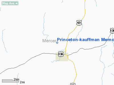
Princeton - Kauffman Memorial Airport |
Location & QuickFacts
| FAA Information Effective: | 2008-09-25 |
| Airport Identifier: | 7MO |
| Airport Status: | Operational |
| Longitude/Latitude: | 093-35-58.3000W/40-25-15.8000N
-93.599528/40.421056 (Estimated) |
| Elevation: | 858 ft / 261.52 m (Surveyed) |
| Land: | 20 acres |
| From nearest city: | 2 nautical miles NW of Princeton, MO |
| Location: | Mercer County, MO |
| Magnetic Variation: | 04E (1985) |
Owner & Manager
| Ownership: | Publicly owned |
| Owner: | City Of Princeton |
| Address: | 507 Main
Princeton, MO 64673 |
| Phone number: | 660-748-4375 |
| Manager: | Leroy Brown |
| Address: | 507 Main
Princeton, MO 64673 |
| Phone number: | 660-748-3189 |
Airport Operations and Facilities
| Airport Use: | Open to public |
| Wind indicator: | Yes |
| Segmented Circle: | No |
| Control Tower: | No |
| Landing fee charge: | No |
| Sectional chart: | Omaha |
| Region: | ACE - Central |
| Boundary ARTCC: | ZKC - Kansas City |
| Tie-in FSS: | COU - Columbia |
| FSS on Airport: | No |
| FSS Toll Free: | 1-800-WX-BRIEF |
| NOTAMs Facility: | COU (NOTAM-d service avaliable) |
Airport Communications
Airport Services
| Airframe Repair: | NONE |
| Power Plant Repair: | NONE |
| Bottled Oxygen: | NONE |
| Bulk Oxygen: | NONE |
Runway Information
Runway 18/36
| Dimension: | 2475 x 100 ft / 754.4 x 30.5 m |
| Surface: | TURF, Good Condition |
| |
Runway 18 |
Runway 36 |
| Longitude: | 093-35-58.2900W | 093-35-58.2900W |
| Latitude: | 40-25-28.0300N | 40-25-03.5800N |
| Traffic Pattern: | Left | Left |
| Displaced threshold: | 0.00 ft | 200.00 ft
RWY 36 DSPLCD THLD IS 3 FT HIGHER THAN RY END. |
| Obstruction: | 18 ft tree, 40.0 ft from runway, 104 ft right of centerline, 2:1 slope to clear | 23 ft tree, 89.0 ft from runway, 11 ft left of centerline, 3:1 slope to clear
RWY 36 APCH SLOPE 13:1 TO DSPLCD THLD; +22 FT TREE; 294 FT FM DSPLCD THLD; 11FT L. |
|
Radio Navigation Aids
| ID |
Type |
Name |
Ch |
Freq |
Var |
Dist |
| TRX | NDB | Trenton | | 400.00 | 03E | 20.5 nm |
| TVK | NDB | Centerville | | 290.00 | 04E | 35.7 nm |
| CNC | NDB | Chariton | | 335.00 | 05E | 37.4 nm |
| CHT | NDB | Chillicothe | | 375.00 | 03E | 39.0 nm |
| BZK | NDB | Brookfield | | 383.00 | 03E | 45.5 nm |
| UNE | NDB | Union County | | 379.00 | 04E | 46.9 nm |
| BQS | VOR/DME | Braymer | 049X | 111.20 | 03E | 49.2 nm |
| LMN | VORTAC | Lamoni | 114X | 116.70 | 07E | 19.9 nm |
| IRK | VORTAC | Kirksville | 093X | 114.60 | 06E | 49.3 nm |
Remarks
- 45 FT UTILITY LINES 1300 FT SOUTH OF RY 36 THR.
- RY SOFT IN SPRING & FALL. CALL ARPT MGR FOR RY CONDITIONS 660-748-4375.
- WILDLIFE ON & INVOF AIRPORT.
- RWY THLDS LINE OF SIGHT OBSTRUCTED BY CHANGES IN TERRAIN GRADE.
- NTSD RY SAFETY AREAS BYD EACH RY END; RY 18 END HAS INCORRECT TERRAIN GRADES, INSUF LENGTH, DITCH, BRUSH AND TREES; RY 36 END HAS INSUF LENGTH, DITCH, FENCE, ROAD, BRUSH AND TREES.
Images and information placed above are from
http://www.airport-data.com/airport/7MO/
We thank them for the data!
| General Info
|
| Country |
United States
|
| State |
MISSOURI
|
| FAA ID |
7MO
|
| Latitude |
40-25-15.031N
|
| Longitude |
093-35-55.797W
|
| Elevation |
858 feet
|
| Near City |
PRINCETON
|
We don't guarantee the information is fresh and accurate. The data may
be wrong or outdated.
For more up-to-date information please refer to other sources.
|
|


