 |
|
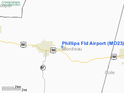
Location & QuickFacts
| FAA Information Effective: | 2008-09-25 |
| Airport Identifier: | MO23 |
| Airport Status: | Operational |
| Longitude/Latitude: | 092-32-00.6810W/38-38-00.1030N
-92.533522/38.633362 (Estimated) |
| Elevation: | 820 ft / 249.94 m (Estimated) |
| Land: | 15 acres |
| From nearest city: | 2 nautical miles NE of California, MO |
| Location: | Moniteau County, MO |
| Magnetic Variation: | 04E (1985) |
Owner & Manager
| Ownership: | Privately owned |
| Owner: | Calmo Flying Club
C/O PAUL A. JOBE. |
| Address: | 901 Pamela Drive
California, MO 65018 |
| Phone number: | 314-796-3956 |
| Manager: | Paul A. Jobe |
| Address: | 901 Pamela Drive
California, MO 65018 |
| Phone number: | 573-796-3956
OR 796-2096. |
Airport Operations and Facilities
| Airport Use: | Private |
| Wind indicator: | Yes |
| Segmented Circle: | No |
| Control Tower: | No |
| Lighting Schedule: | RDO-CTL
ACTVT LIRL RWY 18/36 - 122.8. |
| Landing fee charge: | No |
| Sectional chart: | Kansas City |
| Region: | ACE - Central |
| Boundary ARTCC: | ZKC - Kansas City |
| Tie-in FSS: | COU - Columbia |
| FSS on Airport: | No |
| FSS Toll Free: | 1-800-WX-BRIEF |
Airport Communications
Airport Services
| Airframe Repair: | NONE |
| Power Plant Repair: | NONE |
Runway Information
Runway 18/36
| Dimension: | 2600 x 50 ft / 792.5 x 15.2 m |
| Surface: | TURF, |
| Edge Lights: | Low |
| |
Runway 18 |
Runway 36 |
| Traffic Pattern: | Left | Left |
|
Radio Navigation Aids
| ID |
Type |
Name |
Ch |
Freq |
Var |
Dist |
| ONH | NDB | Noah | | 515.00 | 03E | 13.6 nm |
| VER | NDB | Viertel | | 347.00 | 02E | 20.3 nm |
| JE | NDB | Algoa | | 397.00 | 03E | 22.3 nm |
| FTT | NDB | Guthrie | | 317.00 | 03E | 27.8 nm |
| DMO | NDB | Sedalia | | 281.00 | 03E | 30.5 nm |
| AIZ | NDB | Kaiser | | 377.00 | 05E | 32.3 nm |
| PUR | NDB | Marshall | | 371.00 | 03E | 39.6 nm |
| HCK | NDB | Hawks | | 296.00 | 04E | 48.8 nm |
| SZL | TACAN | Whiteman | 035X | | 04E | 48.1 nm |
| COU | VOR/DME | Columbia | 039X | 110.20 | 03E | 18.2 nm |
| SHY | VOR/DME | Sunshine | 021X | 108.40 | 05E | 35.8 nm |
| VIH | VOR/DME | Vichy | 124X | 117.70 | 06E | 48.4 nm |
| HLV | VORTAC | Hallsville | 089X | 114.20 | 06E | 34.5 nm |
| JEF | VOT | Jefferson City | | 112.00 | | 18.3 nm |
Images and information placed above are from
http://www.airport-data.com/airport/MO23/
We thank them for the data!
| General Info
|
| Country |
United States
|
| State |
MISSOURI
|
| FAA ID |
MO23
|
| Latitude |
38-38-00.103N
|
| Longitude |
092-32-00.681W
|
| Elevation |
820 feet
|
| Near City |
CALIFORNIA
|
We don't guarantee the information is fresh and accurate. The data may
be wrong or outdated.
For more up-to-date information please refer to other sources.
|
|


