 |
|
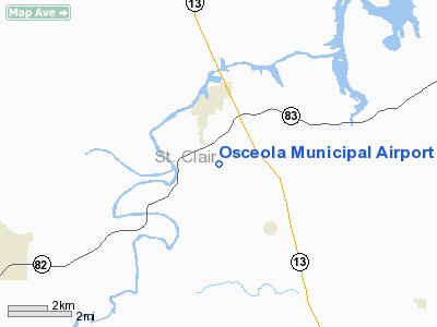
Osceola Municipal Airport |
| Osceola Municipal Airport |
| IATA: none – ICAO: none – FAA LID: 3MO |
| Summary |
| Airport type |
Public |
| Owner |
City of Osceola |
| Serves |
Osceola, Missouri |
| Elevation AMSL |
900 ft / 274 m |
| Coordinates |
38°01′07″N 093°41′36″W / 38.01861°N 93.69333°W / 38.01861; -93.69333 |
| Runways |
| Direction |
Length |
Surface |
| ft |
m |
| 18/36 |
2,430 |
741 |
Turf/Gravel |
| Statistics (2007) |
| Aircraft operations |
470 |
| Based aircraft |
5 |
| Source: Federal Aviation Administration |
Osceola Municipal Airport (FAA LID: 3MO) is a city-owned, public-use airport located two miles (3 km) south of the central business district of Osceola, a city in St. Clair County, Missouri, United States.
Facilities and aircraft
Osceola Municipal Airport covers an area of 41 acres (17 ha) and has one runway designated 18/36 with a 2,430 x 74 ft (741 x 23 m) turf and gravel surface. For the 12-month period ending June 12, 2007, the airport had 470 general aviation aircraft operations, an average of 39 per month. At that time there were 5 single-engine aircraft based at this airport.
The above content comes from Wikipedia and is published under free licenses – click here to read more.
Location & QuickFacts
| FAA Information Effective: | 2008-09-25 |
| Airport Identifier: | 3MO |
| Airport Status: | Operational |
| Longitude/Latitude: | 093-41-35.6000W/38-01-06.9000N
-93.693222/38.018583 (Estimated) |
| Elevation: | 900 ft / 274.32 m (Estimated) |
| Land: | 41 acres |
| From nearest city: | 2 nautical miles S of Osceola, MO |
| Location: | St Clair County, MO |
| Magnetic Variation: | 04E (1985) |
Owner & Manager
| Ownership: | Publicly owned |
| Owner: | City Of Osceola |
| Address: | 210 Olive St. , P.o. Box 561
Osceola, MO 64776 |
| Phone number: | 417-646-8421 |
| Manager: | Peter Hauer |
| Address: | 325 Market St.
Osceola, MO 64776 |
| Phone number: | 800-458-9405 |
Airport Operations and Facilities
| Airport Use: | Open to public |
| Wind indicator: | Yes |
| Segmented Circle: | Yes
NSTD SEGMENTED CIRCLE; INCORRECT SPACING & SIZE OF BARRELS. POOR CONDITION. |
| Control Tower: | No |
| Lighting Schedule: | DUSK-DAWN
ACTVT LIRL RY 18/36 - 122.8. |
| Landing fee charge: | No |
| Sectional chart: | Kansas City |
| Region: | ACE - Central |
| Boundary ARTCC: | ZKC - Kansas City |
| Tie-in FSS: | COU - Columbia |
| FSS on Airport: | No |
| FSS Toll Free: | 1-800-WX-BRIEF |
| NOTAMs Facility: | COU (NOTAM-d service avaliable) |
Airport Communications
Airport Services
| Airframe Repair: | NONE |
| Power Plant Repair: | NONE |
| Bottled Oxygen: | NONE |
| Bulk Oxygen: | NONE |
Runway Information
Runway 18/36
| Dimension: | 2430 x 74 ft / 740.7 x 22.6 m |
| Surface: | TURF-GRVL, Poor Condition
RWY 18/36 ROUGH AND UNEVEN.
25 FT WIDE GRVL STRIP FIRST 900 FT RY 18. |
| Edge Lights: | Non-standard lighting system
RY 18/36 NSTD LIRL; RY 18 - 6 GREEN THLD LGTS; RY 36 - 6 GREEN THLD LGTS; NO DSPLCD THLD LGTS. RY LIGHTING SYSTEM IN POOR CONDITION WITH MANY BROKEN & MISSING EDGE & THLD LGTS. |
| |
Runway 18 |
Runway 36 |
| Longitude: | 093-41-34.8200W | 093-41-36.2900W |
| Latitude: | 38-01-18.9400N | 38-00-54.9400N |
| Traffic Pattern: | Left | Left |
| Displaced threshold: | 0.00 ft | 300.00 ft
DSPLCD THLD DAYLIGHT USE ONLY; DSPLCD THLD +3 FT HIGHER THAN RY END THLD. |
| Obstruction: | 3 ft fence, 60.0 ft from runway, 20:1 slope to clear | 48 ft trees, 81.0 ft from runway, 124 ft left of centerline, 1:1 slope to clear
7:1 TO DSPLCD THLD; 1-40 FT BRUSH & TREES 0-600 FT 100 FT LEFT & RIGHT; 0:1 BASED ON DSPLCD THLD. |
|
Radio Navigation Aids
| ID |
Type |
Name |
Ch |
Freq |
Var |
Dist |
| GLY | NDB | Golden Valley | | 388.00 | 04E | 20.4 nm |
| EAD | NDB | Nevada | | 209.00 | 06E | 30.4 nm |
| HCK | NDB | Hawks | | 296.00 | 04E | 37.1 nm |
| LLU | NDB | Spring River | | 356.00 | 05E | 43.4 nm |
| ILJ | NDB | Willard | | 254.00 | 03E | 44.9 nm |
| DMO | NDB | Sedalia | | 281.00 | 03E | 47.9 nm |
| SZL | TACAN | Whiteman | 035X | | 04E | 43.6 nm |
| BUM | VORTAC | Butler | 106X | 115.90 | 07E | 40.6 nm |
| SGF | VORTAC | Springfield | 116X | 116.90 | 04E | 43.3 nm |
Remarks
- PRIVATE E/W TWY AT RY 18 THR.
- SOUTH END OF RY VERY SOFT AFTER RAIN & IN SPRING.
- NTSD RWY SAFETY AREA BYND RY 18 END; INSUF LENGTH & FENCE.
Images and information placed above are from
http://www.airport-data.com/airport/3MO/
We thank them for the data!
| General Info
|
| Country |
United States
|
| State |
MISSOURI
|
| FAA ID |
3MO
|
| Latitude |
38-01-07.010N
|
| Longitude |
093-41-35.020W
|
| Elevation |
900 feet
|
| Near City |
OSCEOLA
|
We don't guarantee the information is fresh and accurate. The data may
be wrong or outdated.
For more up-to-date information please refer to other sources.
|
|


