 |
|
Northwest Missouri Regional Airport |
| Northwest Missouri Regional Airport |
 |
| IATA: none – ICAO: KEVU – FAA LID: EVU |
| Summary |
| Airport type |
Public |
| Owner |
City of Maryville |
| Serves |
Maryville, Missouri |
| Elevation AMSL |
1,145 ft / 349 m |
| Coordinates |
40°21′12″N 094°55′0″W / 40.35333°N 94.916667°W / 40.35333; -94.916667Coordinates: 40°21′12″N 094°55′0″W / 40.35333°N 94.916667°W / 40.35333; -94.916667 |
| Runways |
| Direction |
Length |
Surface |
| ft |
m |
| 14/32 |
4,600 |
1,402 |
Concrete |
| Statistics (2007) |
| Aircraft operations |
4,550 |
| Based aircraft |
19 |
| Source: Federal Aviation Administration |
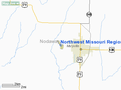
Northwest Missouri Regional Airport (ICAO: KEVU, FAA LID: EVU) is a city-owned public use airport located two nautical miles (3.7 km) west of the central business district of Maryville, a city in Nodaway County, Missouri, United States. The airport is used for general aviation with no commercial airlines.
Although most U.S. airports use the same three-letter location identifier for the FAA and IATA, this airport is assigned EVU by the FAA but has no designation from the IATA. History
The airport was formerly Maryville Memorial Airport and was built following World War II. It was renamed in 2003. It has been operated by the Rankin family for several decades. The family also operates the Rankin Airport in the 102 River bottoms on the east side of Maryville. It derives its codes from Kevin Rankin who filled out the application while in high school in the early 1970s.
Facilities and aircraft
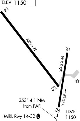
Northwest Missouri Regional Airport covers an area of 171 acres (69 ha) at an elevation of 1,145 feet (349 m) above mean sea level. It has one runway designated 14/32 with a concrete surface measuring 4,600 by 75 foot (1,402 x 23 m). The main runway was extended by 600 feet in 2008. The airport's former second runway is now closed; it had been designated 18/36 and had a 2,002 x 45 ft (610 x 14 m) asphalt surface.
A terminal building was completed in 2007, providing weather information and pilots lounge. The airport is also scheduled to install new lighting and a jet fuel pump in 2009.
For the 12-month period ending September 17, 2007, the airport had 4,550 aircraft operations, an average of 12 per day: 93% general aviation and 7% air taxi. At that time there were 19 aircraft based at this airport: 89% single-engine and 11% multi-engine.
The above content comes from Wikipedia and is published under free licenses – click here to read more.
Location & QuickFacts
| FAA Information Effective: | 2008-09-25 |
| Airport Identifier: | EVU |
| Airport Status: | Operational |
| Longitude/Latitude: | 094-54-55.9427W/40-21-09.3688N
-94.915540/40.352602 (Estimated) |
| Elevation: | 1150 ft / 350.52 m (Surveyed) |
| Land: | 171 acres |
| From nearest city: | 2 nautical miles W of Maryville, MO |
| Location: | Nodaway County, MO |
| Magnetic Variation: | 05E (1990) |
Owner & Manager
| Ownership: | Publicly owned |
| Owner: | City Of Maryville |
| Address: | 415 N Market Box 438
Maryville, MO 64468 |
| Phone number: | 660-562-8001 |
| Manager: | Kevin Rankin, Fbo |
| Address: | 25775 Hawk Rd
Maryville, MO 64468 |
| Phone number: | 660-582-2233
ALTERNATE PHONE: (660) 562-7450 |
Airport Operations and Facilities
| Airport Use: | Open to public |
| Wind indicator: | Yes
NSTD WIND TEE; GREEN LGTS. |
| Segmented Circle: | Yes
NTSD SEG CIRCLE; SMALL CIRCLE & NO SEGMENTATION |
| Control Tower: | No |
| Lighting Schedule: | DUSK-DAWN
MIRL RY 14/32 PRESET ON LOW INTST; TO INCR INTST & ACTVT - CTAF. |
| Beacon Color: | Clear-Green (lighted land airport) |
| Landing fee charge: | No |
| Sectional chart: | Omaha |
| Region: | ACE - Central |
| Boundary ARTCC: | ZMP - Minneapolis |
| Tie-in FSS: | COU - Columbia |
| FSS on Airport: | No |
| FSS Toll Free: | 1-800-WX-BRIEF |
| NOTAMs Facility: | COU (NOTAM-d service avaliable) |
| Federal Agreements: | NGY |
Airport Communications
| CTAF: | 122.800 |
| Unicom: | 122.800 |
Airport Services
| Fuel available: | 100LL |
| Airframe Repair: | MAJOR |
| Power Plant Repair: | MAJOR |
| Bottled Oxygen: | NONE |
| Bulk Oxygen: | NONE |
Runway Information
Runway 14/32
| Dimension: | 4000 x 75 ft / 1219.2 x 22.9 m
WIDTH VARIANCE 42-45 FT. |
| Surface: | CONC, Good Condition
CRACKING WITH GRASS GROWING THRU CRACKS; ROLLING, UNEVEN & VERY ROUGH. |
| Weight Limit: | Single wheel: 12500 lbs. |
| Edge Lights: | Medium
RWY 14/32 MISSING & BROKEN EDGE & THLD LGTS. |
| |
Runway 14 |
Runway 32 |
| Longitude: | 094-55-15.5100W | 094-54-48.3400W |
| Latitude: | 40-21-31.1800N | 40-20-57.5600N |
| Elevation: | 1138.00 ft | 1144.00 ft |
| Alignment: | 127 | 127 |
| Traffic Pattern: | Left | Left |
| Markings: | Non-precision instrument, Good Condition | Non-precision instrument, Good Condition |
|
Runway 18/36
| Dimension: | 2002 x 45 ft / 610.2 x 13.7 m
WIDTH VARIANCE 42-45 FT. |
| Surface: | ASPH, Poor Condition
CRACKING WITH GRASS GROWING THRU CRACKS; ROLLING, UNEVEN & VERY ROUGH. |
| Weight Limit: | Single wheel: 11000 lbs. |
| |
Runway 18 |
Runway 36 |
| Longitude: | 094-54-41.8090W | 094-54-46.1710W |
| Latitude: | 40-21-09.1270N | 40-20-49.6260N |
| Elevation: | 1149.00 ft | 1141.00 ft |
| Alignment: | 127 | 10 |
| Traffic Pattern: | Left | Left |
| Obstruction: | 8 ft brush, 509.0 ft from runway, 67 ft right of centerline, 38:1 slope to clear | 10 ft road, 320.0 ft from runway, 12:1 slope to clear |
|
Radio Navigation Aids
| ID |
Type |
Name |
Ch |
Freq |
Var |
Dist |
| EVU | NDB | Emville | | 317.00 | 05E | 0.3 nm |
| ICL | NDB | Clarinda | | 353.00 | 04E | 23.1 nm |
| AZN | NDB | Amazon | | 233.00 | 06E | 28.2 nm |
| SDA | NDB | Shenandoah | | 411.00 | 05E | 32.9 nm |
| FNB | NDB | Brenner | | 404.00 | 05E | 35.0 nm |
| CRZ | NDB | Corning | | 278.00 | 04E | 39.4 nm |
| AYB | NDB | Auburn | | 430.00 | 05E | 41.0 nm |
| RDK | NDB | Red Oak | | 230.00 | 04E | 42.8 nm |
| UNE | NDB | Union County | | 379.00 | 04E | 44.6 nm |
| AFK | NDB | Nebraska City | | 347.00 | 05E | 45.8 nm |
| EZZ | NDB | Cameron | | 394.00 | 03E | 47.8 nm |
| RBA | VOR/DME | Robinson | 019X | 108.20 | 04E | 38.1 nm |
| STJ | VORTAC | St Joseph | 102X | 115.50 | 08E | 23.6 nm |
| LMN | VORTAC | Lamoni | 114X | 116.70 | 07E | 45.8 nm |
Remarks
- PRVDD APCH SLOPES ARE MAINTD FOR A 20:1 & TRSNL SFC 7:1.
Images and information placed above are from
http://www.airport-data.com/airport/EVU/
We thank them for the data!
| General Info
|
| Country |
United States
|
| State |
MISSOURI
|
| FAA ID |
EVU
|
| Time |
UTC-6(-5DT)
|
| Latitude |
40.352500
40° 21' 09.00" N
|
| Longitude |
-94.915000
094° 54' 54.00" W
|
| Elevation |
1150 feet
351 meters
|
| Type |
Civil
|
| Magnetic Variation |
003° E (01/06)
|
| Beacon |
Yes
|
| Operating Agency |
U.S.CIVIL AIRPORT WHEREIN PERMIT COVERS USE BY TRANSIT MILITARY AIRCRAFT
|
| Operating Hours |
SEE REMARKS FOR OPERATING HOURS OR COMMUNICATIONS FOR POSSIBLE HOURS
|
| Daylight Saving Time |
Second Sunday in March at 0200 to first Sunday in November at 0200 local time (Exception Arizona and that portion of Indiana in the Eastern Time Zone)
|
We don't guarantee the information is fresh and accurate. The data may
be wrong or outdated.
For more up-to-date information please refer to other sources.
|
|


