 |
|
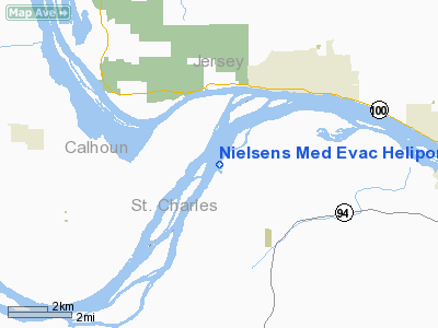
Nielsens Med Evac Heliport |
Location & QuickFacts
| FAA Information Effective: | 2008-09-25 |
| Airport Identifier: | 1MU9 |
| Airport Status: | Operational |
| Longitude/Latitude: | 090-28-35.4210W/38-56-07.1760N
-90.476506/38.935327 (Estimated) |
| Elevation: | 425 ft / 129.54 m (Estimated) |
| Land: | 1 acres |
| From nearest city: | 6 nautical miles N of Saint Charles, MO |
| Location: | St Charles County, MO |
| Magnetic Variation: | 01E (1995) |
Owner & Manager
| Ownership: | Privately owned |
| Owner: | Cherry Point Llc |
| Address: | 9024 St Charles Rock Road
St Louis, MO 63114 |
| Phone number: | 314-490-4433 |
| Manager: | Scott Nielsen |
| Address: | 9024 St Charles Rock Road
St Louis, MO 63114 |
| Phone number: | 314-490-4433 |
Airport Operations and Facilities
| Airport Use: | Private
FOR MEDICAL USE ONLY. |
| Segmented Circle: | No |
| Control Tower: | No |
| Landing fee charge: | No |
| Sectional chart: | St Louis |
| Region: | ACE - Central |
| Boundary ARTCC: | ZKC - Kansas City |
| Tie-in FSS: | STL - Saint Louis |
| FSS on Airport: | No |
| FSS Toll Free: | 1-800-WX-BRIEF |
Runway Information
Helipad H1
| Dimension: | 100 x 100 ft / 30.5 x 30.5 m |
| Surface: | TURF, |
| |
Runway H1 |
Runway |
| Traffic Pattern: | Left | Left |
|
Radio Navigation Aids
| ID |
Type |
Name |
Ch |
Freq |
Var |
Dist |
| LM | NDB | Oblio | | 338.00 | 00E | 8.1 nm |
| CVM | NDB | Civic Memorial | | 263.00 | 02E | 19.8 nm |
| LTD | NDB | Litchfield | | 371.00 | 01E | 39.9 nm |
| BL | NDB | Belleville | | 362.00 | 02E | 44.1 nm |
| FES | NDB | Festus | | 269.00 | 01E | 44.6 nm |
| PPQ | NDB | Pittsfield | | 344.00 | 02E | 44.7 nm |
| SKE | TACAN | Scott | 059X | | 02E | 37.5 nm |
| CSX | VOR/DME | Cardinal | 111Y | 116.45 | 00E | 12.2 nm |
| STL | VORTAC | St Louis | 121X | 117.40 | 01E | 4.5 nm |
| FTZ | VORTAC | Foristell | 045X | 110.80 | 05E | 27.3 nm |
| TOY | VORTAC | Troy | 107X | 116.00 | 04E | 28.7 nm |
| STL | VOT | St Louis Lambert | | 111.00 | | 12.5 nm |
| SUS | VOT | Spirit Of St Louis | | 112.20 | | 18.3 nm |
Remarks
- PRVDD MAINTAIN CLEAR 8:1 LANDING AREA GLIDE SLOP; MAINTAIN CLEAR 2:1 TRANSITIONAL SURFACE ACCESS TO ARPT IS CONTROLLED BY PPR; ARFF EQUIPMENT ON SITE; DALGT OPNSONLY.
Images and information placed above are from
http://www.airport-data.com/airport/1MU9/
We thank them for the data!
| General Info
|
| Country |
United States
|
| State |
MISSOURI
|
| FAA ID |
1MU9
|
| Latitude |
38-56-07.176N
|
| Longitude |
090-28-35.421W
|
| Elevation |
425 feet
|
| Near City |
SAINT CHARLES
|
We don't guarantee the information is fresh and accurate. The data may
be wrong or outdated.
For more up-to-date information please refer to other sources.
|
|


