 |
|
Coordinates: 36°59′34″N 091°42′52″W / 36.99278°N 91.71444°W / 36.99278; -91.71444
| Mountain View Airport |
| IATA: none – ICAO: KMNF – FAA LID: MNF |
| Summary |
| Airport type |
Public |
| Owner |
City of Mountain View |
| Serves |
Mountain View, Missouri |
| Elevation AMSL |
1,181 ft / 360 m |
| Runways |
| Direction |
Length |
Surface |
| ft |
m |
| 10/28 |
5,005 |
1,526 |
Asphalt |
| Statistics (2005) |
| Aircraft operations |
7,330 |
| Source: Federal Aviation Administration |
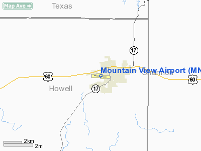
Mountain View Airport (ICAO: KMNF, FAA LID: MNF) is a public airport located one mile (2 km) southwest of the central business district of Mountain View, a city in Howell County, Missouri, United States. It is owned by the City of Mountain View.
Although most U.S. airports use the same three-letter location identifier for the FAA and IATA, Mountain View Airport is assigned MNF by the FAA but has no designation from the IATA (which assigned MNF to the airport on Mana Island in Fiji).
Facilities and aircraft
Mountain View Airport covers an area of 120 acres (49 ha) which contains one asphalt paved runway (10/28) measuring 5,005 x 75 ft (1,526 x 23 m). For the 12-month period ending August 31, 2005, the airport had 7,330 aircraft operations, an average of 20 per day: 97% general aviation, 3% air taxi and <1% military.
The above content comes from Wikipedia and is published under free licenses – click here to read more.
Location & QuickFacts
| FAA Information Effective: | 2008-09-25 |
| Airport Identifier: | MNF |
| Airport Status: | Operational |
| Longitude/Latitude: | 091-42-52.0420W/36-59-34.1770N
-91.714456/36.992827 (Estimated) |
| Elevation: | 1181 ft / 359.97 m (Surveyed) |
| Land: | 120 acres |
| From nearest city: | 1 nautical miles SW of Mountain View, MO |
| Location: | Howell County, MO |
| Magnetic Variation: | 05E (1975) |
Owner & Manager
| Ownership: | Publicly owned |
| Owner: | City Of Mountain View |
| Address: | Box 115 233 W 2nd
Mountain View, MO 65548 |
| Phone number: | 417-934-6806 |
| Manager: | Charles Webster |
| Address: | Box 115 233 W 2nd
Mountain View, MO 65548 |
| Phone number: | 417-934-6806 |
Airport Operations and Facilities
| Airport Use: | Open to public |
| Wind indicator: | Yes |
| Segmented Circle: | No |
| Control Tower: | No |
| Lighting Schedule: | DUSK-DAWN |
| Beacon Color: | Clear-Green (lighted land airport)
BEACON ON WATER TWR, 1950 FT NORTH OF RY 10 THR. |
| Landing fee charge: | No |
| Sectional chart: | Kansas City |
| Region: | ACE - Central |
| Boundary ARTCC: | ZKC - Kansas City |
| Tie-in FSS: | COU - Columbia |
| FSS on Airport: | No |
| FSS Toll Free: | 1-800-WX-BRIEF |
| NOTAMs Facility: | COU (NOTAM-d service avaliable) |
| Federal Agreements: | NY1 |
Airport Communications
| CTAF: | 122.800 |
| Unicom: | 122.800 |
Airport Services
| Fuel available: | 100LLA1+ |
| Airframe Repair: | MINOR |
| Power Plant Repair: | MAJOR |
Runway Information
Runway 10/28
| Dimension: | 5005 x 75 ft / 1525.5 x 22.9 m |
| Surface: | ASPH, Good Condition
MANY CRACKS WITH GRASS AND WEEDS GROWING IN THEM. |
| Edge Lights: | Medium |
| |
Runway 10 |
Runway 28 |
| Longitude: | 091-43-22.4890W | 091-42-21.5940W |
| Latitude: | 36-59-38.1430N | 36-59-30.2100N |
| Elevation: | 1181.00 ft | 1139.00 ft |
| Alignment: | 99 | 127 |
| Traffic Pattern: | Left | Left |
| Markings: | Non-precision instrument, Good Condition
RWY 10 MARKINGS FADED. | Non-precision instrument, Good Condition
RWY 28 MARKINGS FADED. |
| Crossing Height: | 0.00 ft | 52.00 ft |
| Displaced threshold: | 320.00 ft | 0.00 ft |
| VASI: | | 4-light PAPI on left side |
| Visual Glide Angle: | 0.00° | 3.00° |
| Obstruction: | 20 ft trees, 297.0 ft from runway, 119 ft left of centerline, 4:1 slope to clear
20:1 TO DSPLCD THLD; +1-95 FT HIGHY GND; BRUSH & TREES;0-1395 FT L & R; 0-19:1 BASED ON DSPLCD THLD.
RWY 10 +1-41 FT BRUSH; TREES & HIGH GND 0-200 FT FM RY END L & R. | 66 ft tree, 1120.0 ft from runway, 2 ft right of centerline, 13:1 slope to clear
RWY 28 +1-5' HGH GND, 0-200' FM RWY END, 0-200' L. |
|
Radio Navigation Aids
| ID |
Type |
Name |
Ch |
Freq |
Var |
Dist |
| MNF | NDB | Mountain View | | 365.00 | 03E | 0.1 nm |
| UNO | NDB | Pomona | | 335.00 | 02E | 11.3 nm |
| AOV | NDB | Bilmart | | 341.00 | 02E | 46.3 nm |
| BHN | NDB | Buckhorn | | 391.00 | 03E | 46.3 nm |
| AJX | NDB | Ash Flat | | 344.00 | 03E | 49.1 nm |
| TBN | VOR | Forney | | 110.00 | 03E | 49.4 nm |
| HUW | VOR/DME | Hutton | 053X | 111.60 | 02E | 11.5 nm |
| MAP | VORTAC | Maples | 081X | 113.40 | 06E | 36.1 nm |
Remarks
- WILDLIFE ON & INVOF ARPT.
- NTSD RY SAFETY AREAS BEYOND EACH RY END; INCORRECT TERRAIN GRADES, BRUSH AND SMALL TREES.
Images and information placed above are from
http://www.airport-data.com/airport/MNF/
We thank them for the data!
| General Info
|
| Country |
United States
|
| State |
MISSOURI
|
| FAA ID |
MNF
|
| Latitude |
36-59-34.177N
|
| Longitude |
091-42-52.042W
|
| Elevation |
1181 feet
|
| Near City |
MOUNTAIN VIEW
|
We don't guarantee the information is fresh and accurate. The data may
be wrong or outdated.
For more up-to-date information please refer to other sources.
|
|


