 |
|
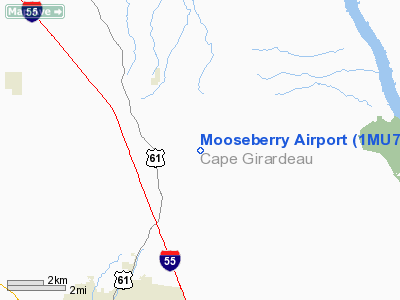
Location & QuickFacts
| FAA Information Effective: | 2008-09-25 |
| Airport Identifier: | 1MU7 |
| Airport Status: | Operational |
| Longitude/Latitude: | 089-36-43.3470W/37-27-55.1790N
-89.612041/37.465328 (Estimated) |
| Elevation: | 480 ft / 146.30 m (Estimated) |
| Land: | 0 acres |
| From nearest city: | 6 nautical miles NE of Jackson, MO |
| Location: | Cape Girardeau County, MO |
| Magnetic Variation: | 01E (1995) |
Owner & Manager
| Ownership: | Privately owned |
| Owner: | Norvald J. Reppen, Jr. |
| Address: | 479 Mooseberry Lane
Jackson, MO 63755 |
| Phone number: | 573-334-6523 |
| Manager: | Norvald J. Reppen, Jr. |
| Address: | 479 Mooseberry Lane
Jackson, MO 63755 |
| Phone number: | 573-334-6523 |
Airport Operations and Facilities
| Airport Use: | Private |
| Wind indicator: | Yes |
| Segmented Circle: | No |
| Control Tower: | No |
| Sectional chart: | Memphis |
| Region: | ACE - Central |
| Boundary ARTCC: | ZKC - Kansas City |
| Tie-in FSS: | COU - Columbia |
| FSS on Airport: | No |
| FSS Toll Free: | 1-800-WX-BRIEF |
Runway Information
Runway 18/36
| Dimension: | 1000 x 40 ft / 304.8 x 12.2 m |
| Surface: | TURF, |
| |
Runway 18 |
Runway 36 |
| Traffic Pattern: | Left | Left |
|
Radio Navigation Aids
| ID |
Type |
Name |
Ch |
Freq |
Var |
Dist |
| CIR | NDB | Cairo | | 397.00 | 00E | 30.6 nm |
| PJY | NDB | Pinckneyville | | 215.00 | 00E | 32.8 nm |
| CHQ | NDB | Charleston | | 208.00 | 01E | 39.2 nm |
| SAR | NDB | Sparta | | 239.00 | 01E | 41.1 nm |
| PRI | NDB | Perrine | | 367.00 | 02E | 42.9 nm |
| DXE | NDB | Dexter | | 423.00 | 00E | 43.7 nm |
| BDD | NDB | Bellgrade | | 254.00 | 00E | 49.0 nm |
| CGI | VOR/DME | Cape Girardeau | 076X | 112.90 | 01E | 14.4 nm |
| MWA | VOR/DME | Marion | 041X | 110.40 | 04E | 33.4 nm |
| FAM | VORTAC | Farmington | 104X | 115.70 | 01E | 32.2 nm |
| CNG | VORTAC | Cunningham | 078X | 113.10 | 03E | 46.1 nm |
Remarks
- PRVDD 20:1 RY APCH & 7:1 TRANSITIONAL SFC MAINTAINED.
Images and information placed above are from
http://www.airport-data.com/airport/1MU7/
We thank them for the data!
| General Info
|
| Country |
United States
|
| State |
MISSOURI
|
| FAA ID |
1MU7
|
| Latitude |
37-27-55.179N
|
| Longitude |
089-36-43.347W
|
| Elevation |
480 feet
|
| Near City |
JACKSON
|
We don't guarantee the information is fresh and accurate. The data may
be wrong or outdated.
For more up-to-date information please refer to other sources.
|
|


