 |
|
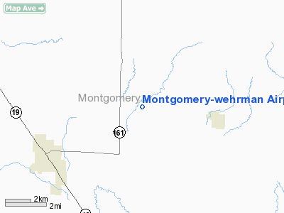
Montgomery-wehrman Airport |
Location & QuickFacts
| FAA Information Effective: | 2008-09-25 |
| Airport Identifier: | 4MO |
| Airport Status: | Operational |
| Longitude/Latitude: | 091-25-09.5700W/39-00-45.1470N
-91.419325/39.012541 (Estimated) |
| Elevation: | 778 ft / 237.13 m (Surveyed) |
| Land: | 11 acres |
| From nearest city: | 4 nautical miles NE of Montgomery City, MO |
| Location: | Montgomery County, MO |
| Magnetic Variation: | 03E (1985) |
Owner & Manager
| Ownership: | Privately owned |
| Owner: | Howard Wehrman |
| Address: | 154 Arpt Rd
Montgomery City, MO 63361 |
| Phone number: | 373-564-2876 |
| Manager: | Howard Wehrman |
| Address: | 154 Arpt Rd
Montgomery City, MO 63361 |
| Phone number: | 573-564-2876 |
Airport Operations and Facilities
| Airport Use: | Open to public |
| Wind indicator: | Yes |
| Segmented Circle: | No |
| Control Tower: | No |
| Lighting Schedule: | PHONE REQ
FOR LIRL RY 03/21 CALL AMGR. NIGHT OPNS NOT RECOMMENDED. |
| Landing fee charge: | No |
| Sectional chart: | Kansas City |
| Region: | ACE - Central |
| Boundary ARTCC: | ZKC - Kansas City |
| Tie-in FSS: | STL - Saint Louis |
| FSS on Airport: | No |
| FSS Toll Free: | 1-800-WX-BRIEF |
| NOTAMs Facility: | STL (NOTAM-d service avaliable) |
Airport Communications
Airport Services
| Fuel available: | 100LL |
| Airframe Repair: | MINOR |
| Power Plant Repair: | MAJOR |
Runway Information
Runway 03/21
| Dimension: | 2360 x 75 ft / 719.3 x 22.9 m |
| Surface: | TURF-GRVL, Poor Condition
UNEVEN SFC.
GRVL PORTION 1360 FT BY 10 FT. |
| Edge Lights: | Non-standard lighting system
NSTD LIRL; LGTS MOUNTED ON FENCE AT VARIOUS DISTANCES; NO THR LGTS. |
| |
Runway 03 |
Runway 21 |
| Traffic Pattern: | Left | Left |
| Obstruction: | 25 ft trees | 75 ft trees, 345.0 ft from runway, 4:1 slope to clear |
|
Radio Navigation Aids
| ID |
Type |
Name |
Ch |
Freq |
Var |
Dist |
| FTT | NDB | Guthrie | | 317.00 | 03E | 29.2 nm |
| JE | NDB | Algoa | | 397.00 | 03E | 41.4 nm |
| HAE | NDB | Hannibal | | 411.00 | 03E | 43.0 nm |
| ONH | NDB | Noah | | 515.00 | 03E | 44.8 nm |
| LM | NDB | Oblio | | 338.00 | 00E | 46.0 nm |
| PPQ | NDB | Pittsfield | | 344.00 | 02E | 48.0 nm |
| UUV | NDB | Sullivan | | 356.00 | 02E | 48.2 nm |
| COU | VOR/DME | Columbia | 039X | 110.20 | 03E | 39.3 nm |
| FTZ | VORTAC | Foristell | 045X | 110.80 | 05E | 28.4 nm |
| HLV | VORTAC | Hallsville | 089X | 114.20 | 06E | 33.6 nm |
| STL | VORTAC | St Louis | 121X | 117.40 | 01E | 44.7 nm |
| SUS | VOT | Spirit Of St Louis | | 112.20 | | 41.6 nm |
| JEF | VOT | Jefferson City | | 112.00 | | 42.6 nm |
Remarks
- NSTD RY SAFETY AREA BYD EACH RY END; INCORRECT GRADE & LENGTH, DITCH AT RY 21 THR, FENCE & TREES AT RY 03 THR.
- RWY 03/21; OLD TANKS, TREES, & BRUSH AT VARIOUS DISTANCES ALONG EAST & WEST RWY EDGES IN RY OBJECT FREE AREA & PRIMARY SURFACE. NUMEROUS TALL TREES IN APPROACH & TRANSITIONAL SURFACES AT EACH RY END.
Images and information placed above are from
http://www.airport-data.com/airport/4MO/
We thank them for the data!
| General Info
|
| Country |
United States
|
| State |
MISSOURI
|
| FAA ID |
4MO
|
| Latitude |
39-00-45.147N
|
| Longitude |
091-25-09.570W
|
| Elevation |
778 feet
|
| Near City |
MONTGOMERY CITY
|
We don't guarantee the information is fresh and accurate. The data may
be wrong or outdated.
For more up-to-date information please refer to other sources.
|
|


