|
 |
|
||||
|
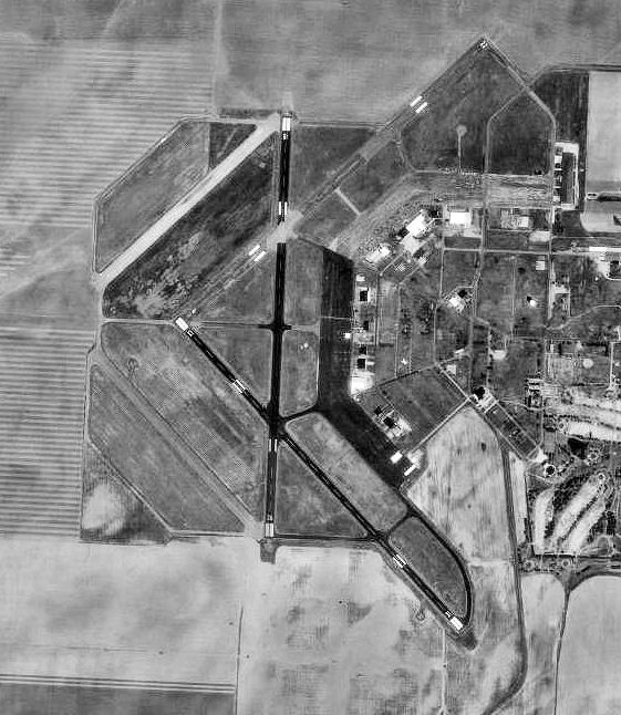
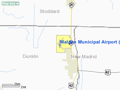
Malden Regional Airport (IATA: MAW, ICAO: KMAW, FAA LID: MAW) is a city-owned public-use airport located three nautical miles (6 km) north of the central business district of Malden, a city in Dunklin County, Missouri, United States. This airport is included in the FAA's National Plan of Integrated Airport Systems for 2009–2013, which categorized it as a general aviation facility. It was previously known as Malden Municipal Airport and is located on the site of the former Malden Army Airfield and Malden Air Base. HistoryAcquired in 1941; construction proceeded throughout 1942 and was activated as Malden Army Airfield on 6 January 1943 by the United States Army Air Forces. Assigned to Eastern Flying Training Command as a basic (level 1) flying training airfield. Flying training was conducted by 319th Aviation Group (Basic). Squadrons were 1069; 1070; 1071 and 1072 Flying Training Squadrons, equipped with Fairchild PT-19s as the primary trainer used. Also had several PT-17 Stearmans and a few P-40 Warhawks assigned. Malden also had five local auxiliary airfields in vicinity for emergency and overflow landings. Conducted contract flying training and flying training until inactivated and the facility being transferred to I Troop Carrier Command 15 June 1944. Under I TCC, the mission was to train Troop Carrier Groups for missions in the Pacific Theater and the planned Invasion of Japan. However I TCC never began training operations with end of war with Japan in August. Inactivated on 30 September 1945. and turned over to Army Corps of Engineers on 1 February 1946. Transferred to War Assets Administration who conveyed facility to the local government as an airport in 1948. Reactivated as Malden Air Base on 11 July 1951 under USAF Air Training Command. Mission of Malden was to train pilots caused by shortages due to expansion of the Air Force during the Cold War. Anderson Air Activities of Milwaukee, Wisconsin conducted basic contract flying training under 3305th Pilot Training Group (Contract Flying). With pilot production decreasing, the ATC commander suggested closing Malden, in early 1959. However, it wasn't until late December 1959 that Headquarters USAF approved the ATC request. The last primary class graduated on 29 June 1960, and one day later ATC terminated Anderson's training contract. On 26 July the command discontinued the 3305th Pilot Training Group (Contract Primary) with the implementation of USAF Consolidated Pilot Training. Facilities and aircraftMalden Regional Airport covers an area of 2,740 acres (1,109 ha) at an elevation of 294 feet (90 m) above mean sea level. It has two asphalt paved runways: 14/32 is 4,999 by 80 feet (1,524 x 24 m) and 18/36 is 5,011 by 75 feet (1,527 x 23 m). For the 12-month period ending August 28, 2008, the airport had 7,000 aircraft operations, an average of 19 per day: 93% general aviation, 4% air taxi, and 3% military. At that time there were 19 aircraft based at this airport: 84% single-engine and 16% multi-engine. The above content comes from Wikipedia and is published under free licenses – click here to read more.
Location & QuickFacts
Owner & Manager
Airport Operations and Facilities
Airport Communications
Airport Services
Runway InformationRunway 13/31
Runway 18/36
Radio Navigation Aids
Remarks
Images and information placed above are from We thank them for the data!
We don't guarantee the information is fresh and accurate. The data may
be wrong or outdated.
|
|||||||||||||||||||||||||||||||||||||||||||||||||||||||||||||||||||||||||||||||||||||||||||||||||||||||||||||||||||||||||||||||||||||||||||||||||||||||||||||||||||||||||||||||||||||||||||||||||||||||||||||||||||||||||||||||||||||||||||||||||||||||||||||||||||||||||||||||||||||||||||||||||||||||||||||||||||||||||||||||||||||||||||||||||||||||||||||||||||||||||||||||||||||||||||

 |
|
Copyright 2004-2026 © by Airports-Worldwide.com, Vyshenskoho st. 36, Lviv 79010, Ukraine Legal Disclaimer |