|
 |
|
||||
|
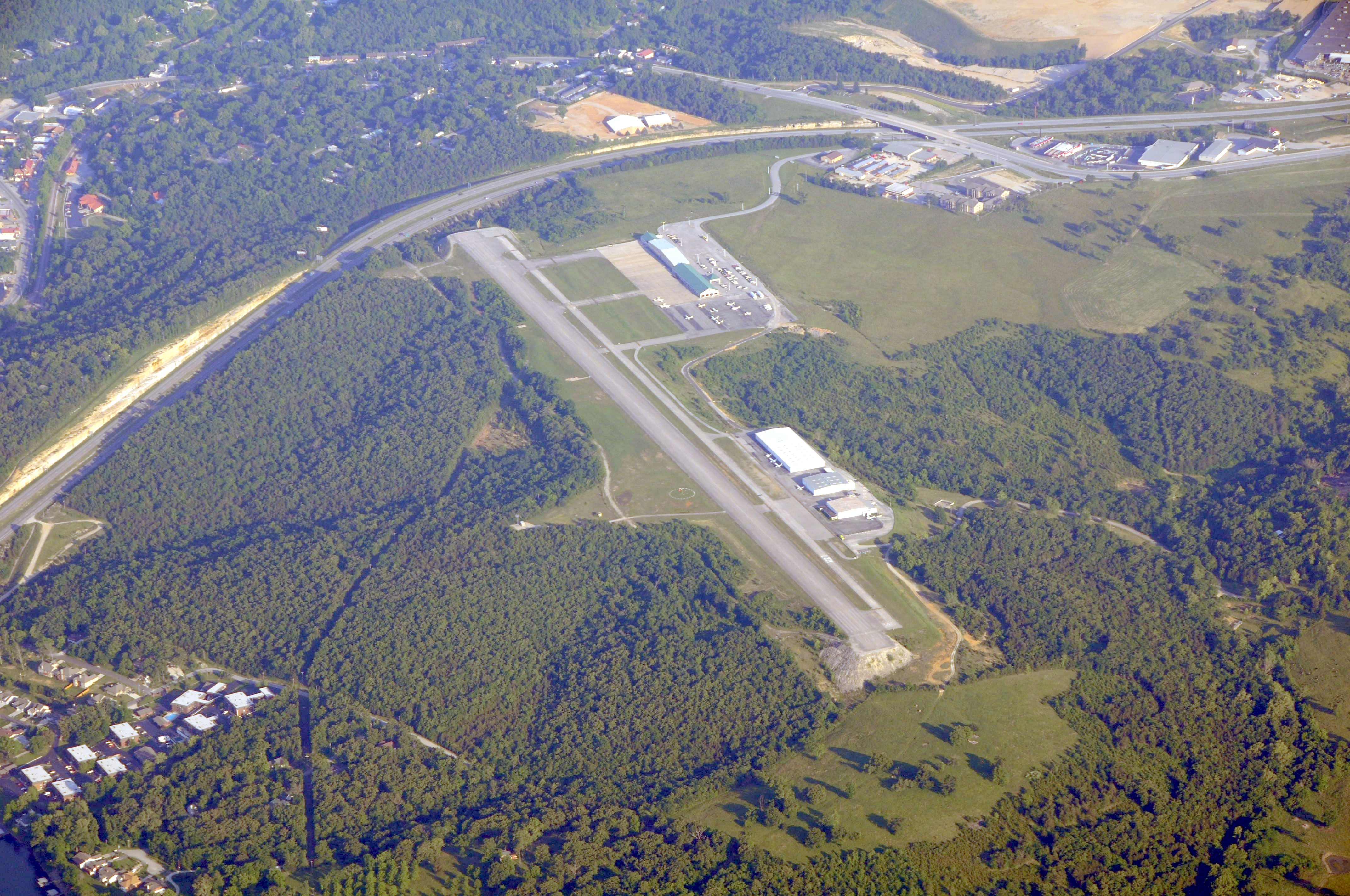
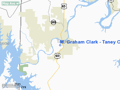
M. Graham Clark Field, Taney County Airport (IATA: PLK, ICAO: KPLK, FAA LID: PLK) is a county-owned public-use airport located one nautical mile (2 km) northeast of the central business district of Point Lookout, in Taney County, Missouri, United States. It is one mile southwest of Branson, Missouri and a few yards west of the old downtown area of Hollister, Missouri. HistoryM. Graham Clark Field was originally developed as a private airport by the College of the Ozarks for use in their aviation science department, and was originally officially associated with the village of Point Lookout, Missouri, a small village on a bluff overlooking the White River Valley which was later completely bought out and overwhelmed by the development of the college. The airport identifier, PLK, was based on the name of the town officially associated with the facility under a federal grant through which the college originally developed the airport. The airport was named after M. Graham Clark, the president of the college at the time the airport was originally constructed. College of the Ozarks closed down its aviation science department in 2003. Shortly thereafter, the airport was donated by the college to Taney County so that the Branson and Hollister community would not lose its important general aviation airport. A private entity had contracted with the college to provide commercial airline service to Clark Field, serving Branson, in the late-1990s, but the venture failed and the terminal building, fire department building, and associated ramp were turned over to the college. The airport currently does not have any scheduled commercial airline service. Since the opening of the newly developed Branson Airport and the construction of new terminal facilities at the Springfield-Branson National Airport there is no expectation of airline service at Clark Field. Clark Field is operated by Taney County as a public general aviation airport. The FBO is operated by the Taney County Airport Board. Repair services are available from Branson Aircraft Repair, LLC. Helicopter charter, touring, and flight training if offered, as well. Facilities and aircraftTaney County Airport covers an area of 40 acres (16 ha) at an elevation of 940 feet (287 m) above mean sea level. The only runway is runway 11-29. A GPS Approach is published for both runways. The runway is also equipped with a medium intensity approach lighting system. The runway is 3,738 feet (1,139 m) in length and 100 feet (30 m) feet wide. For the 12-month period ending November 30, 2005, the airport had 11,200 aircraft operations, an average of 30 per day: 96% general aviation, 4% air taxi, <1% military. At that time there were 51 aircraft based at this airport: 73% single-engine, 25% multi-engine and 2% helicopter. Operating PeculiaritiesPrevailing WindsThe direction of the prevailing winds are typically from the north or from the southwest. The runway was constructed west-northwest and east-southeast due to the terrain, creating a prevailing crosswind. This "built-in crosswind" was considered a desired attribute when the airport was used to train pilots, allowing them to obtain extensive crosswind procedure training, although there were several relatively minor crosswind accidents. General Aviation TrafficClark Field has at times been one of the busiest general aviation airports in the region. It was at one time ranked the fourth busiest airport by number of aircraft operations in the state of Missouri behind Lambert-St. Louis International Airport, Kansas City Downtown Airport, and Spirit of St. Louis Airport, outranking Kansas City International Airport and Springfield-Branson National Airport. The airport serves helicopter operations. Also, there is a substantial antique airplane collector on the field and the field is popular with other operators flying aircraft without radios. There is no control tower as it is an uncontrolled field. It is not uncommon for there to be several aircraft in the pattern at the same time. Name ConfusionThe airport was named after a person, M. Graham Clark, and the donation agreement between the college and the county calls for the airport to always be named M. Graham Clark Field, though it is usually referred to as Clark Field, or simply as "Clark." The official Facilities Directory lists the airport under the name of the town it was originally officially associated with, Point Lookout, so some pilots will refer to the airport as "Point Lookout." The Kansas City Sectional Chart depicts the airport as Clark-Taney County, but on two lines, so some pilots refer to it as "Clark County." Some local pilots refer to it as "Taney County." Some transient pilots associating the airport with the principal city of Branson refer to it as "Branson," despite the proximity of the newly developed Branson Airport about eight miles to the southeast. The use of so many names for the same airport has also been known to cause radio confusion in dense traffic. Accident HistoryThis airport was free of any fatal accident history for several decades, but there have been a few fatal accidents associated with the field in recent years, including:
All other accidents have been comparatively minor, including a few gear-up accidents, several incidents involving mechanical problems, a few tailwheel failures or ground looped landings, and a few crosswind related accidents involving student pilots. There have also been a few aircraft over-run the end of the runway, including a chartered Beechcraft King Air in the mid-1990s. The above content comes from Wikipedia and is published under free licenses – click here to read more.
Location & QuickFacts
Owner & Manager
Airport Operations and Facilities
Airport Communications
Airport Services
Runway InformationRunway 11/29
Radio Navigation Aids
Remarks
Images and information placed above are from We thank them for the data!
We don't guarantee the information is fresh and accurate. The data may
be wrong or outdated.
|
||||||||||||||||||||||||||||||||||||||||||||||||||||||||||||||||||||||||||||||||||||||||||||||||||||||||||||||||||||||||||||||||||||||||||||||||||||||||||||||||||||||||||||||||||||||||||||||||||||||||||||||||||||||||||||||||||||||||||||||||||||||||||||||||||||||||||||||||||||||||||||||||||||||||||||||||||||||||||||

 |
|
Copyright 2004-2026 © by Airports-Worldwide.com, Vyshenskoho st. 36, Lviv 79010, Ukraine Legal Disclaimer |