|
|
Lambert - St Louis International Airport |
| Lambert St. Louis International Airport |
 |
| IATA: STL – ICAO: KSTL – FAA LID: STL
Location of the Lambert-St. LouisInternational Airport
|
| Summary |
| Airport type |
Public |
| Owner |
City of St. Louis |
| Serves |
Greater St. Louis, Missouri |
| Location |
Unincorporated St. Louis County 10 miles (16 km) NW of St. Louis |
| Elevation AMSL |
605 ft / 184.4 m |
| Coordinates |
38°44′50″N 90°21′41″W / 38.74722°N 90.36139°W / 38.74722; -90.36139 |
| Runways |
| Direction |
Length |
Surface |
| ft |
m |
| 12R/30L |
11,019 |
3,359 |
Concrete |
| 12L/30R |
9,003 |
2,744 |
Concrete |
| 11/29 |
9,000 |
2,743 |
Concrete |
| 6/24 |
7,602 |
2,317 |
Concrete |
| Statistics (2009) |
| Aircraft operations |
209,057 |
| Passenger volume |
12,796,302 |
| Cargo tonnage |
|
| Area (acres) |
2,800 |
| Source: Federal Aviation Administration and STL Airport |
Lambert-St. Louis International Airport (IATA: STL, ICAO: KSTL, FAA LID: STL) is the primary airport for St. Louis, Missouri, United States and the surrounding area. It is the largest airport in the state.
The airport lies outside the St. Louis city limits in St. Louis County and is owned and operated by the City of St. Louis. Its land sits in the cities of Berkeley and Bridgeton and in an unincorporated area. The airport has nonstop flights to and from more than 88 national and international destinations. In 2009, 12.8 million passengers traveled through the airport.
In 1982, Trans World Airlines (TWA) established its hub at Lambert. Over 30 million passengers traveled through the airport per year in 1999 and 2000. American Airlines bought TWA and the Lambert hub in 2001. American reduced service levels gradually from 2003 through 2009 and ended its focus-city operation on April 5, 2010. In May 2010, Southwest Airlines increased its operations and flight schedule and became the airport's largest airline in terms of passengers carried and daily flights. Delta Airlines is the airport's second-busiest operating airline. History
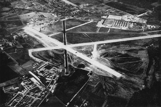 | |
Aerial view of NAS St. Louis in the mid-1940s. |
 | |
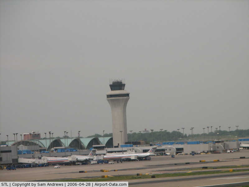
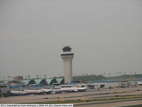
Control tower and main terminal |
 | |
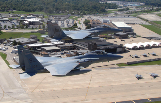
131st Fighter Wing and American Airlines Maintenance Ramp At Lambert Airport |
The airport was originally a balloon launching base named Kinloch Field. The Wright brothers and their Exhibition Team visited the field while touring with their aircraft. During a visit to St. Louis, Theodore Roosevelt flew with pilot Arch Hoxsey on October 11, 1910, becoming the first U.S. president to fly. Later, Kinloch hosted the first experimental parachute jump.
In 1920, Major Albert Bond Lambert, part of the Lambert Pharmacal Company that first sold Listerine and the first person to receive a pilot's license in St. Louis, bought the field and added hangars and a passenger terminal. Charles Lindbergh's first piloting job was flying airmail for Robertson Airlines from Lambert Field; he left the airport for New York about a week before his record-breaking flight to Paris in 1927. Later that year, Lambert sold the airport to the City of St. Louis, making it the first municipally-owned airport in the United States.
In the late 1920s, Lambert Field became the first airport with an air-traffic control system — albeit one that communicated with pilots via waving flags. The first controller was Archie League.
Before World War II, Robertson Airlines, Marquette Airlines, and Eastern Air Lines provided passenger service to St. Louis. During the war, the airport became a manufacturing base for McDonnell Aircraft and Curtiss-Wright. After the war, Minoru Yamasaki was commissioned to design a new passenger terminal at Lambert. Completed in 1956, the four-domed design inspired terminals at John F. Kennedy International Airport in New York City and Paris-Charles de Gaulle Airport.
In the 1970s, St. Louis city officials proposed to replace the airport with a new one in suburban Illinois. But after Missouri residents strongly objected, Lambert received a $290-million expansion that lengthened the runways, increased the number of gates to 81, and boosted its operational capacity by 50 percent. (The proposed Illinois airport was later built anyway; MidAmerica St. Louis Airport opened in 1997 in Mascoutah, Illinois. As of 2010, no major carriers provide service there.)
In 1982, Trans World Airlines (TWA) moved its hub from Kansas City International Airport. The move made TWA the dominant carrier at Lambert, and turned the St. Louis airport into one of the busiest in the country. The airport grew in importance for TWA after the airline declared bankruptcy in 1993; by the late 1990s it was the airline's dominant hub. But the airport's influence waned after American Airlines (AA) bought TWA and merged its flight operations in 2001. Lambert became a reliever for AA's existing hubs at Chicago O'Hare and Dallas/Fort Worth International Airport, and transatlantic service was discontinued. AA transferred many mainline TWA routes to American Connection, a group of affiliated regional carriers. After the 2003 cutbacks, AA introduced American Eagle service at its St. Louis hub in May 2005. Unlike American Connection, American Eagle is wholly owned by AMR Corporation, the parent company of American Airlines and American Eagle.
In 2006, the United States Air Force announced plans to turn the 131st Fighter Wing into the 131st Bomb Wing. The 20 F-15C aircraft were moved to the 120th Fighter Wing in Montana and Hickam AFB in Hawaii. The pilots and maintainers moved to Whiteman AFB to fly and maintain the B-2 Spirit Stealth Bomber, and be the first ANG Wing to fly it. The base formally shut down in June 2009. The final two F-15C Eagles did a low approach over the field, then flew away. The event was attended by more than 2,200 people who said goodbye to a part of airport history for over 85 years.
As of 2009, Concourse D, previously used by Ozark and later TWA, was largely empty and closed off; Concourse B had limited traffic; and the distal portion of Concourse C was not used for commercial traffic. In September 2009, American Airlines announced that, as a part of the airline's restructuring, it will reduce its operations to 36 daily flights to nine destinations in the summer of 2010. These cuts will end the remaining hub operation.
On October 21, 2009, Southwest Airlines announced that the airline will increase service with a "major expansion" in St. Louis by May 2010. The airline will increase service to 83 daily departures from St. Louis, replacing American as the carrier with the most daily flights after American's service cuts scheduled for Summer 2010.
Facilities
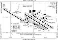
 | |
STL FAA Airport Diagram
|
Runways
Lambert-St. Louis International Airport covers 2,800 acres (1,133 ha) and has four runways:
- Runway 12R/30L: 11,019 x 200 ft (3,359 x 61 m), Surface: Concrete
- Runway 12L/30R: 9,003 x 150 ft (2,744 x 46 m), Surface: Concrete
- Runway 11/29: 9,000 x 150 ft (2,743 x 46 m), Surface: Concrete
- Runway 6/24: 7,602 x 150 ft (2,317 x 46 m), Surface: Concrete
Terminals
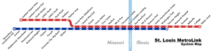
The airport has two terminals with a total of 5 concourses. International flights and passengers use Terminal 2, whose lower level holds the Immigration and Customs gates. Passengers can move between the terminals on complimentary buses that run continuously, or via MetroLink.
- Terminal 1 (formerly Main Terminal) includes:
- Concourse A: Gates A2-A6, A8-A10, A12, A14-A19, A21
- Concourse B: Gates B2-B4, B6-B8, B10, B12, B14, B16
- Concourse C: Gates C1-C3, C5-C10, C12, C15-C19, C21, C23-C25, C27-C32, C36, C38
- Concourse D: Gates D2, D4, D6, D8, D10. Gates D12 through D36 were closed in October 2008.
- Terminal 2 (formerly East Terminal) includes:
- Concourse E: Gates E4, E6, E8, E10, E12, E14, E16, E18, E20, E22, E24, E25, E29, E31, E33.
Public transportation
Light rail
Each of the airport's terminals has a rail station with direct trains to downtown St. Louis on MetroLink's Red Line. One-ride and all-day tickets can be purchased from vending machines on the platforms. MetroLink lines provide direct or indirect service to St. Louis, the Clayton area, and Illinois suburbs in St. Clair County.
MetroBus
Two MetroBus lines serve the Lambert Bus Port, which is located next to the intermediate parking lot, and accessible via the tunnel from Terminal 1:
- 49 Lindbergh
- 66 Clayton-Airport
Airline lounges
The American Airlines Admirals Club at the B/C/D connector is large for its type, with seating for 244. It has a bar/snack area, basic ticketing functions, espresso bar, three private conference rooms, and complimentary use of six PCs, dataports, copier, printer and paper shredder.
Lambert's USO facility, located on the lower level of the Main Terminal next to baggage claim carousel #M6, is one of the largest in the country. Open 24 hours a day, it serves more than 120,000 military men and women each year.
Black Americans in Flight mural
Black Americans in Flight is a mural that depicts African-American aviators and their contributions to aviation since 1917. It is located in Terminal 1 / Main Terminal on the lower level near the entrance to gates C and D and baggage claim. The mural consists of five panels and measures 8 feet tall and 51 feet long. The first panel includes the Tuskegee Institute and the Tuskegee Airmen, Eugene Bullard, Bessie Coleman, and Willa Brown (first African-American woman commercial pilot in United States). The second panel shows Benjamin O. Davis Jr., Clarence "Lucky" Lester and Joseph Ellesberry. The third panel shows Gen. Daniel "Chappie" James, Capt. Ronald Radliff, and Capt. Marcella Hayes. The fourth and fifth panels show Ronald McNair, who died in the Space Shuttle Challenger disaster in 1986, Guion Bluford, who in 1983 became the first African American in space, and Mae Jemison, the first African America woman in space. Spencer Taylor and Solomon Thurman created the mural in 1990.
Aircraft on display
Two aircraft from the Missouri History Museum hang from Lambert's ceilings. The first is a 1934 Monocoupe D-145 near the Terminal 1 security checkpoint. Charles Lindbergh bought it in 1934 from the Lambert Aircraft Corporation and flew it as his personal plane.
The second aircraft, a red Monocoupe 110 Special, manufactured in St. Louis in 1931, hangs in Terminal 2.
Until 1998, a Ryan B-1 Brougham, a replica of the Spirit of St. Louis, hung next to the D-145.
Aircraft production
Lambert's runways have long been used for test flights and deliveries of military aircraft by McDonnell Douglas, which built its world headquarters and principal assembly plant next to the airport; and now by Boeing, which bought McDonnell and now uses its St. Louis facilities as headquarters for its Boeing Defense, Space & Security division. The plant currently builds the F-15 Strike Eagle, F/A-18 Super Hornet and EA-18 Growler; and is home to Boeing Phantom Works.
Operations
Cargo
Several air cargo airlines operate at Lambert, including:
- FedEx Express - Indianapolis, IN (DC-10, A300F4-600)
- UPS Airlines - Louisville, KY (MD-11)
- DHL
- Capital Cargo International Airlines - Toledo, OH (727-200)
- Integrated Airline Services, Inc.
Passengers
Passenger traffic plummeted after the 9/11 attacks and the sale of TWA to American Airlines. In 2000, 30,558,991 passengers traveled through the airport; in 2004, 13 million; in 2006, 15.2 million.
September 2007 saw a 4.2 percent increase over September 2006, while the nine months from January to September saw nearly 5.9 million passengers, up 1.2% from the same 9-month period in 2006. Among the major national airlines, Frontier Airlines showed the biggest gain in boarding passengers in September 2007, with 12,139 passengers originating from St. Louis, up 57 percent from the previous September. As well, International Charter Airlines service increased 11.2 percent in September.
Airlines and destinations
| Airlines |
Destinations |
Terminal/Concourse |
| Air Canada Jazz |
Toronto-Pearson |
1A |
| Air Choice One |
Burlington (IA), Decatur (IL) |
2E |
| AirTran Airways |
Atlanta, Orlando |
1C |
| AirTran Airways operated by SkyWest Airlines |
Milwaukee |
1C |
| Alaska Airlines |
Seattle/Tacoma |
1A |
| American Airlines |
Chicago-O'Hare, Dallas/Fort Worth, Los Angeles, Miami, New York-LaGuardia, Washington-Reagan |
1C |
| American Eagle |
New York-JFK |
1C |
| Cape Air |
Cape Girardeau, Kirksville, Marion (IL), Quincy |
1D |
| Continental Express operated by Chautauqua Airlines |
Cleveland |
1A |
| Continental Express operated by ExpressJet Airlines |
Cleveland, Houston-Intercontinental, Newark |
1A |
| Delta Air Lines |
Atlanta, Detroit, Minneapolis/St. Paul, Salt Lake City |
1A |
| Delta Connection operated by Atlantic Southeast Airlines |
Memphis, Washington-Reagan [begins October 31] |
1A |
| Delta Connection operated by Comair |
Cincinnati/Northern Kentucky, Memphis, New York-JFK [begins November 1], New York-LaGuardia, Raleigh-Durham [begins November 1] |
1A |
| Delta Connection operated by Compass Airlines |
Detroit, Minneapolis/St. Paul, New York-LaGuardia |
1A |
| Delta Connection operated by Mesaba Airlines |
Cincinnati/Northern Kentucky, Detroit, Minneapolis/St. Paul, New York-JFK [ends October 31], Salt Lake City |
1A |
| Delta Connection operated by Pinnacle Airlines |
Cincinnati/Northern Kentucky, Memphis, Raleigh-Durham [begins November 1] |
1A |
| Delta Connection operated by Shuttle America |
New York-LaGuardia |
1A |
| Delta Connection operated by SkyWest Airlines |
Minneapolis/St. Paul, Salt Lake City [begins October 1] |
1A |
| Frontier Airlines |
Cancún, Denver, Puerto Vallarta [seasonal; begins December 16] |
1C |
| Frontier Airlines operated by Chautauqua Airlines |
Milwaukee |
1C |
| Southwest Airlines |
Albuquerque, Baltimore, Birmingham (AL), Boston, Chicago-Midway, Cleveland [Ends March 11], Columbus (OH), Dallas-Love, Denver, Detroit, Fort Lauderdale, Fort Myers, Houston-Hobby, Kansas City, Las Vegas, Little Rock, Los Angeles, Louisville, Minneapolis/St. Paul, Nashville, New Orleans, Oklahoma City, Omaha, Orlando, Philadelphia, Phoenix, Raleigh/Durham, San Diego, Seattle/Tacoma [seasonal], Tampa, Tulsa |
2E |
| Sun Country Airlines |
Puerto Vallarta |
2E |
| United Airlines |
San Francisco |
1A |
| United Express operated by GoJet Airlines |
Chicago-O'Hare, Denver, Washington-Dulles |
1A |
| United Express operated by Trans States Airlines |
Chicago-O'Hare, Denver, Washington-Dulles |
1A |
| USA3000 Airlines |
Cancún, Cincinnati/Northern Kentucky, Fort Myers, Montego Bay, Puerto Vallarta, Punta Cana |
2E |
| US Airways |
Charlotte, Phoenix |
1A |
| US Airways Express operated by Air Wisconsin |
Philadelphia |
1A |
| US Airways Express operated by Mesa Airlines |
Charlotte |
1A |
| US Airways Express operated by Republic Airlines |
Charlotte, Philadelphia |
1A |
| US Airways Express operated by Trans States Airlines |
Pittsburgh |
1A |
Expansion
Runway 11/29
A fourth runway was opened in 2006, a $1.1 billion project that was the costliest public works program in St. Louis history.
During the late 1990s, Lambert Field was ranked as high as the eighth-busiest U.S. airport (measured by flights, not passengers), thanks to TWA's hub operations, Southwest Airlines' growing traffic, and commuter traffic to smaller cities in Illinois, Missouri, Arkansas, Iowa and Kentucky. Congestion caused delays during peak hours; the problem was worse when bad weather reduced the number of usable runways from three to one. Lambert briefly redesignated the taxiway immediately north of runway 12L-30R as runway 13-31 and used it for commuter and general aviation traffic. Moreover, traffic projections made in the 1980s and 1990s predicted yet more growth, enough to strain the airport and the national air traffic system.
This led to the construction of a 9,000-foot runway, dubbed Runway 11/29, parallel to the two larger existing runways. The project required the move of seven major roads and the destruction of about 2,000 homes, six churches and four schools in Bridgeton, Missouri.
Construction began in 1998, and continued even as traffic at the airport declined after the 9/11 attacks, the purchase of Trans World Airlines by American Airlines in April 2001, and American's 2003 reduction in flights.
On April 13, 2006, American Airlines Flight 2470 became the first commercial airliner to land on the new runway.
As of 2009, the runway was shunned by fuel- and time-conscious airlines because it is farther from terminals than the older runways; an estimated 5% of flights use it.
21st-century renovation
In February 2007, airport officials announced the largest renovation in the airport's history: a $105 million effort to overhaul the Main Terminal, from road signs to window panes; add stores and restaurants; install terrazzo floors; and construct pedestrian bridges from the parking garage to the ticketing area. A domed glass canopy will arch above sidewalks and roadways, protecting visitors from bad weather. The job is to be completed in 2012.
In December 2009, airport officials renamed the Main and East terminals Terminal 1 and Terminal 2, and began installing new signs the following month.
Cargo and passenger service expansion plans
In 2008, Air China was reported to be planning a cargo hub at Lambert as part of its international cargo and passenger service expansion. The United States Department of Commerce allowed expansion of the foreign trade zone near Lambert airport on February 13, 2009. As of November 2009, negotiations were still on track.
Accidents
- On 9 January 1984, Douglas C-47B C-GSCA of Skycraft Air Transport crashed on take-off, killing one of its two crew members. The aircraft was on an international cargo flight to Toronto Pearson International Airport, Canada. Both engines lost power shortly after take-off. The aircraft had been fueled with JET-A instead of 100LL.
Lambert in fiction
Television
- In the "Airport" episode of the television show Newsradio, bad weather keeps Bill and Dave at Lambert for the entire show.
- In "The Airport" episode of the television show Seinfeld, the characters leave from Lambert.
Film
- In the movie Planes, Trains & Automobiles, Neal Page (Steve Martin) attempts to rent a car at Lambert, with disastrous (and profanity-laden) consequences.
- In the 1986 movie Manhunter, FBI agents fly in to Lambert during their pursuit of the killer.
- Part of the 1991 movie The Silence of the Lambs was shot at Lambert.
- In the movie Anger Management, Dave Buznik (Adam Sandler) takes a flight to Lambert.
- Part of the 2006 movie The Lucky Ones, set in Austin, Texas, was shot at Lambert.
- One scene from the 2009 movie The Informant, directed by Steven Soderbergh, was filmed at Lambert.
- The 2009 movie Up in the Air was filmed in the St. Louis area, including in Lambert's Concourse D, between March 3 and the end of April. The film stars George Clooney.
The above content comes from Wikipedia and is published under free licenses – click here to read more.
|
 |
(Click on the photo to enlarge) |
|
 |
(Click on the photo to enlarge) |
|
 |
(Click on the photo to enlarge) |
|
 |
(Click on the photo to enlarge) |
|
 |
(Click on the photo to enlarge) |
|
 |
(Click on the photo to enlarge) |
|
 |
(Click on the photo to enlarge) |
|
 |
(Click on the photo to enlarge) |
|
 |
(Click on the photo to enlarge) |
Location & QuickFacts
| FAA Information Effective: | 2008-09-25 |
| Airport Identifier: | STL |
| Airport Status: | Operational |
| Longitude/Latitude: | 090-22-12.1040W/38-44-55.3100N
-90.370029/38.748697 (Estimated) |
| Elevation: | 618 ft / 188.37 m (Surveyed) |
| Land: | 2800 acres |
| From nearest city: | 10 nautical miles NW of St Louis, MO |
| Location: | St Louis City County, MO |
| Magnetic Variation: | 00E (2000) |
Owner & Manager
| Ownership: | Publicly owned |
| Owner: | City Of St Louis |
| Address: | 1320 Market St.
St Louis, MO 63103
202 MUNICIPAL COURT BLDG. |
| Phone number: | 573-662-3201 |
| Manager: | Mr. Richard E Hrabko
DIRECTOR OF AIRPORTS. |
| Address: | Box 10212
St Louis, MO 63145 |
| Phone number: | 314-426-8000 |
Airport Operations and Facilities
| Airport Use: | Open to public |
| Wind indicator: | Yes |
| Segmented Circle: | No |
| Control Tower: | Yes |
| Lighting Schedule: | DUSK-DAWN |
| Beacon Color: | Clear-Green (lighted land airport) |
| Landing fee charge: | Yes
LNDG FEE BASED ON ACFT WEIGHT COLLECTED BY FBO. |
| Sectional chart: | St Louis |
| Region: | ACE - Central |
| Boundary ARTCC: | ZKC - Kansas City |
| Tie-in FSS: | STL - Saint Louis |
| FSS on Airport: | No |
| FSS Toll Free: | 1-800-WX-BRIEF |
| NOTAMs Facility: | STL (NOTAM-d service avaliable) |
| Certification type/date: | I D S 05/1973 |
| Federal Agreements: | NGPY3 |
Airport Communications
Airport Services
| Fuel available: | 100LLA
FUEL: A, A+ (AIR BP ST LOUIS, C314-895-8788.) |
| Airframe Repair: | MAJOR |
| Power Plant Repair: | MAJOR |
| Bottled Oxygen: | HIGH/LOW |
| Bulk Oxygen: | HIGH/LOW |
Runway Information
Runway 06/24
| Dimension: | 7602 x 150 ft / 2317.1 x 45.7 m |
| Surface: | CONC, Good Condition |
| Surface Treatment: | Saw-cut or plastic Grooved |
| Weight Limit: | Single wheel: 75000 lbs.
Dual wheel: 176000 lbs.
Dual tandem wheel: 280000 lbs.
Dual dual tandem wheel: 660000 lbs.
RUNWAY LOAD CAPACITY: ST175
RUNWAY LOAD CAPACITY: ST175
RUNWAY LOAD CAPACITY: ST175 |
| Edge Lights: | High |
| |
Runway 06 |
Runway 24 |
| Longitude: | 090-22-52.4335W | 090-21-27.0159W |
| Latitude: | 38-44-48.0410N | 38-45-22.3823N |
| Elevation: | 551.00 ft | 534.00 ft |
| Alignment: | 63 | 127 |
| ILS Type: | ILS/DME
| ILS/DME
|
| Traffic Pattern: | Left | Left |
| Markings: | Precision instrument, Good Condition | Precision instrument, Good Condition |
| Arresting: | BAK12 | |
| Crossing Height: | 50.00 ft | 53.00 ft |
| VASI: | 4-light PAPI on right side | 4-light PAPI on left side |
| Visual Glide Angle: | 3.00° | 3.00° |
| RVR Equipment: | touchdown | touchdown |
| Approach lights: | MALSR | MALS |
| Obstruction: | 31 ft tree, 825.0 ft from runway, 250 ft left of centerline, 20:1 slope to clear | 18 ft sign, 750.0 ft from runway, 450 ft right of centerline, 30:1 slope to clear |
| Decleard distances: | Take off run available 7602.00 ft
Take off distance available 7602.00 ft
Actual stop distance available 7352.00 ft
Landing distance available 7352.00 ft
| Take off run available 7602.00 ft
Take off distance available 7602.00 ft
Actual stop distance available 7602.00 ft
Landing distance available 7602.00 ft
|
|
Runway 11/29
| Dimension: | 9001 x 150 ft / 2743.5 x 45.7 m |
| Surface: | CONC, |
| Surface Treatment: | Saw-cut or plastic Grooved |
| Weight Limit: | Single wheel: 75000 lbs.
Dual wheel: 200000 lbs.
Dual tandem wheel: 325000 lbs.
Dual dual tandem wheel: 700000 lbs.
RUNWAY LOAD CAPACITY: ST175
RUNWAY LOAD CAPACITY: ST175
RUNWAY LOAD CAPACITY: ST175 |
| Edge Lights: | High |
| |
Runway 11 |
Runway 29 |
| Longitude: | 090-24-35.5490W | 090-22-59.3881W |
| Latitude: | 38-45-35.8293N | 38-44-48.4560N |
| Elevation: | 618.00 ft | 556.00 ft |
| Alignment: | 122 | 127 |
| ILS Type: | ILS/DME
| ILS/DME
|
| Traffic Pattern: | Left | Left |
| Markings: | Precision instrument, Good Condition | Precision instrument, Good Condition |
| Crossing Height: | 57.00 ft | 56.00 ft |
| VASI: | 4-light PAPI on right side | 4-light PAPI on left side |
| Visual Glide Angle: | 3.00° | 3.00° |
| Approach lights: | ALSF2 | ALSF2 |
| Centerline Lights: | Yes | Yes |
| Touchdown Lights: | Yes | Yes |
| Decleard distances: | Take off run available 9001.00 ft
Take off distance available 9001.00 ft
Actual stop distance available 9001.00 ft
Landing distance available 9001.00 ft
| Take off run available 9001.00 ft
Take off distance available 9001.00 ft
Actual stop distance available 9001.00 ft
Landing distance available 9001.00 ft
|
|
Runway 12L/30R
| Dimension: | 9003 x 150 ft / 2744.1 x 45.7 m |
| Surface: | CONC, Good Condition |
| Surface Treatment: | Saw-cut or plastic Grooved |
| Weight Limit: | Single wheel: 75000 lbs.
Dual wheel: 200000 lbs.
Dual tandem wheel: 350000 lbs.
Dual dual tandem wheel: 760000 lbs.
RUNWAY LOAD CAPACITY: ST175
RUNWAY LOAD CAPACITY: ST175
RUNWAY LOAD CAPACITY: ST175 |
| Edge Lights: | High |
| |
Runway 12L |
Runway 30R |
| Longitude: | 090-21-58.6574W | 090-20-22.5072W |
| Latitude: | 38-45-06.4062N | 38-44-18.9854N |
| Elevation: | 528.00 ft | 604.00 ft |
| Alignment: | 122 | 127 |
| ILS Type: | LDA/DME
| ILS/DME
|
| Traffic Pattern: | Left | Right |
| Markings: | Precision instrument, Good Condition | Precision instrument, Good Condition |
| Crossing Height: | 64.00 ft | 71.00 ft |
| VASI: | 4-light PAPI on right side | 4-light PAPI on right side |
| Visual Glide Angle: | 3.00° | 3.00° |
| RVR Equipment: | touchdown, midfield, rollout | touchdown, midfield, rollout |
| Approach lights: | ALSF2 | ALSF2
ALSF2 UNMONITORED EXCP WHEN RVR VIS BLO 1800 FT. |
| Runway End Identifier: | Yes | |
| Centerline Lights: | Yes | Yes |
| Touchdown Lights: | Yes | Yes |
| Obstruction: | 54 ft bldg, 2025.0 ft from runway, 600 ft left of centerline, 33:1 slope to clear | 42 ft twr, 1850.0 ft from runway, 580 ft right of centerline, 39:1 slope to clear |
| Decleard distances: | Take off run available 9003.00 ft
Take off distance available 9003.00 ft
Actual stop distance available 9003.00 ft
Landing distance available 9003.00 ft
| Take off run available 9003.00 ft
Take off distance available 9003.00 ft
Actual stop distance available 9003.00 ft
Landing distance available 9003.00 ft
|
|
Runway 12R/30L
| Dimension: | 11019 x 200 ft / 3358.6 x 61.0 m |
| Surface: | CONC, Good Condition |
| Surface Treatment: | Saw-cut or plastic Grooved |
| Weight Limit: | Single wheel: 75000 lbs.
Dual wheel: 200000 lbs.
Dual tandem wheel: 350000 lbs.
Dual dual tandem wheel: 760000 lbs.
RUNWAY LOAD CAPACITY: ST175
RUNWAY LOAD CAPACITY: ST175
RUNWAY LOAD CAPACITY: ST175 |
| Edge Lights: | High |
| |
Runway 12R |
Runway 30L |
| Longitude: | 090-22-44.9667W | 090-20-47.2732W |
| Latitude: | 38-45-14.0486N | 38-44-16.0148N |
| Elevation: | 542.00 ft | 586.00 ft |
| Alignment: | 122 | 127 |
| ILS Type: | ILS
| ILS
|
| Traffic Pattern: | Right | Left |
| Markings: | Precision instrument, Good Condition | Precision instrument, Good Condition |
| Arresting: | BAK12 | BAK12 |
| Crossing Height: | 69.00 ft | 58.00 ft |
| Displaced threshold: | 467.00 ft | 201.00 ft |
| VASI: | 4-light PAPI on left side | 4-light PAPI on right side
PAPI OFFSET 5 DEGREES S TO ACCOMMODATE LDA/DME APCH TO RY 30L. |
| Visual Glide Angle: | 3.00° | 3.00° |
| RVR Equipment: | touchdown | touchdown |
| Approach lights: | MALSR | MALSR |
| Runway End Identifier: | | Yes |
| Centerline Lights: | Yes | No |
| Touchdown Lights: | Yes | No |
| Obstruction: | 30 ft road, 300.0 ft from runway, 500 ft left of centerline, 3:1 slope to clear
APCH RATIO FM DSPLCD THR 25:1. | 86 ft sign, 2800.0 ft from runway, 900 ft left of centerline, 30:1 slope to clear
APCH RATIO FM DSPLCD THR 34:1. |
| Decleard distances: | Take off run available 11019.00 ft
Take off distance available 11019.00 ft
Actual stop distance available 11019.00 ft
Landing distance available 10562.00 ft
| Take off run available 11019.00 ft
Take off distance available 11019.00 ft
Actual stop distance available 11019.00 ft
Landing distance available 10819.00 ft
|
|
Runway 12X
| Dimension: | 0 x 0 ft / 0.0 x 0.0 m |
| Surface: | , |
| |
Runway 12X |
Runway |
| ILS Type: | ILS/DME
| |
| Traffic Pattern: | Left | Left |
|
Runway 30X
| Dimension: | 0 x 0 ft / 0.0 x 0.0 m |
| Surface: | , |
| |
Runway 30X |
Runway |
| ILS Type: | LDA/DME
| |
| Traffic Pattern: | Left | Left |
|
Radio Navigation Aids
| ID |
Type |
Name |
Ch |
Freq |
Var |
Dist |
| LM | NDB | Oblio | | 338.00 | 00E | 5.8 nm |
| CVM | NDB | Civic Memorial | | 263.00 | 02E | 17.0 nm |
| FES | NDB | Festus | | 269.00 | 01E | 33.2 nm |
| BL | NDB | Belleville | | 362.00 | 02E | 33.5 nm |
| LTD | NDB | Litchfield | | 371.00 | 01E | 41.0 nm |
| SAR | NDB | Sparta | | 239.00 | 01E | 48.0 nm |
| UUV | NDB | Sullivan | | 356.00 | 02E | 48.4 nm |
| SKE | TACAN | Scott | 059X | | 02E | 27.2 nm |
| CSX | VOR/DME | Cardinal | 111Y | 116.45 | 00E | 0.5 nm |
| STL | VORTAC | St Louis | 121X | 117.40 | 01E | 8.5 nm |
| TOY | VORTAC | Troy | 107X | 116.00 | 04E | 21.2 nm |
| FTZ | VORTAC | Foristell | 045X | 110.80 | 05E | 28.4 nm |
| STL | VOT | St Louis Lambert | | 111.00 | | 0.4 nm |
| SUS | VOT | Spirit Of St Louis | | 112.20 | | 14.2 nm |
Remarks
- WAIVER TO CONDUCT SIMULTANEOUS APCHS TO PARALLEL RYS SEPARATED BY 1,300 FT IN EFFECT.
- A-GEAR: A-G ARE KEPT IN RECESSED POSN TIL REQ FOR USE. TWR MUST BE NOTIFIED AT LEAST 5 SEC PRIOR TO ENGAGEMENT SO THAT CABLE MAY BE RAISED.
- FLUID: SP LHOX
- OIL: O-128-133-(148 MIL) SOAP
- TWY C NOT RECOMMENDED FOR ACFT DUE NUMEROUS REFUL TRUCKS. WG TIP CLNC WITH GND VEH NOT ADEQUATE ALONG N SIDE OF MAIN TRML APN.
- MISC: MIL ACFT PLANNING TO ARR WHEN WX IS ANTICIPATED TO BE LESS THAN 1200'/5 MUST FILE F;T PLAN BEFORE 0900Z++.
- MISC: WAIVER TO CONDUCT SIMULTANEOUS APCH TO PARL RWY SEPARATED BY 1300' IN EFF.
- AF: BOEING RAMP CLSD TO ALL ACFT EXC OFFL BUS ONLY. PPR FR FLT OPS 48 HR PRIOR, BOEING ST. LOUIS, C314-232-2917.
- AF: CTC BOEING FLT OPS FOR RWY A-G STATUS.
- AF: SECURITY CLNR RQR. LTD PRK. NO MAINT OR SVC.
- AF: INBD ACFT INDICATE DESTN AS BOEING. INBD ACFT FOR BOEING, CTC MAC RDO ON 382.6 OR 123.2 15 MIN OUT.
- AF: FTR TYPE ACFT ARR BOEING MUST HAVE AMMO DOWN LOADED PRIOR TO ARR. BOEING RDO AND FLT OPS OPR 1315-2200Z++MON-FRI.
- ANG: CTC ANG OPS FOR A-G STATUS, DSN 824-6310, C314-527-6310.
- A-GEAR RY 06 1450 FT; RY 12R 1090 FT & RY 30L 1300 FT FROM THR.
- TAXIING ACFT USE CAUTION EARLY MORNING & LATE AFTERNOON DUE SUN GLARE.
- ANG: NML ANG OPS IS 1200-2100Z++ MON-FRI, EXC HOL. ANG RAMP CLSD DUR NON-DUTY HR. ANG-RAMP CLSD TO ALL ACFT EXC OFFL BUS, PPR REQ FOR TRAN ACFT, CTC DSN 824-6207, C314-527-6207. TRAN ACFT CTC BANJO OPS 297.9 15 MIN PRIOR ARR.
- ANG: NO TRAN MAINT AVBL. WHEN REQ ANG MAINT WILL PROVIDE PRK LCTN. TRAN CREW RESPONSIBLE FOR WG TIP SEPARATION. LTD TRAN PRK USE EXTREME CAUTION TAXIING ON ANG RAMP.
- ANG: POTENTIAL HAZ TAXIING AND PRK C-PAD DUE TO NUMEROUS CIV ACFT AND VEH TFC. 12' BLAST FENCE S OF C-PAD. DIST FR EDGE OF BLAST FENCE TO C-PAD W END 94', E END 27'.
- ANG: NUMEROUS LINES PAINTED ON C-PAD, NO DEFINED TAXI LINES FOR LARGE MIL ACFT TO PROVIDE WG TIP CLNC WHEN PRK. CTC ANG OPS FOR A-G STATUS, DSN 824-6310, C314-527-6310.
- ASDE-X SURVEILLANCE SYSTEM I USE: PILOTS SHOULD OPERATE TRANSPONDERS WITH MODE C ON ALL TXWYS AND RWYS.
- NO DESIGNATED TAXILANES OR APRON TWYS LCTD ON ACR RAMPS.
Images and information placed above are from
http://www.airport-data.com/airport/STL/
We thank them for the data!
| General Info
|
| Country |
United States
|
| State |
MISSOURI
|
| FAA ID |
STL
|
| Latitude |
38-44-51.673N
|
| Longitude |
090-21-35.963W
|
| Elevation |
604 feet
|
| Near City |
ST LOUIS
|
We don't guarantee the information is fresh and accurate. The data may
be wrong or outdated.
For more up-to-date information please refer to other sources.
|
|