|
|
| Joplin Regional Airport |
| IATA: JLN – ICAO: KJLN |
| Summary |
| Airport type |
Public |
| Operator |
City of Joplin |
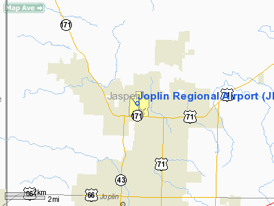
| Location |
Joplin, Missouri |
| Elevation AMSL |
981 ft / 299 m |
| Coordinates |
37°09′07″N 94°29′54″W / 37.15194°N 94.49833°W / 37.15194; -94.49833Coordinates: 37°09′07″N 94°29′54″W / 37.15194°N 94.49833°W / 37.15194; -94.49833 |
| Runways |
| Direction |
Length |
Surface |
| ft |
m |
| 13/31 |
6,502 |
1,982 |
Asphalt |
| 18/36 |
6,500 |
1,981 |
Asphalt |
| 5/23 |
3,604 |
1,098 |
Asphalt |
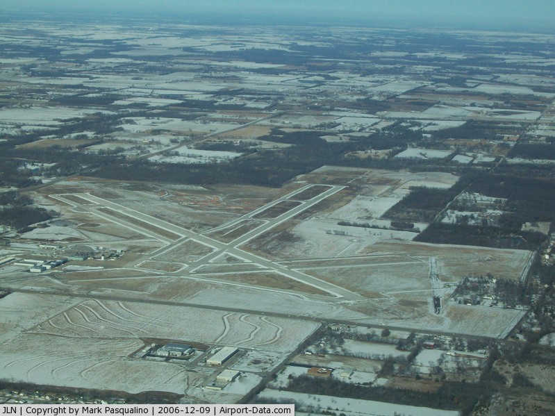
Joplin Regional Airport (IATA: JLN, ICAO: KJLN) is a public airport located four miles (6 km) north of the central business district (CBD) of Joplin, a city in Jasper County, Missouri, USA. The airport covers 970 acres (393 ha) and has three runways. It offers commercial airline service subsidized by the Essential Air Service program.
Air Midwest commenced service to Kansas City International Airport on August 1, 2006 (operating as U.S. Airways Express). The airline also started flying to Dallas/Fort Worth International Airport on October 5, 2006 (operating as Mesa Airlines). At times the airport received service to St. Louis, Missouri and Memphis, Tennessee.
Airlines and destinations
| Airlines |
Destinations |
| American Eagle operated by Executive Airlines |
Dallas/Fort Worth [begins December 2010] |
| Great Lakes Airlines |
Kansas City [ends December 2010] |
The above content comes from Wikipedia and is published under free licenses – click here to read more.
|
 |
(Click on the photo to enlarge) |
Location & QuickFacts
| FAA Information Effective: | 2008-09-25 |
| Airport Identifier: | JLN |
| Airport Status: | Operational |
| Longitude/Latitude: | 094-29-53.7660W/37-09-06.5290N
-94.498268/37.151814 (Estimated) |
| Elevation: | 981 ft / 299.01 m (Surveyed) |
| Land: | 970 acres |
| From nearest city: | 4 nautical miles N of Joplin, MO |
| Location: | Jasper County, MO |
| Magnetic Variation: | 04E (2000) |
Owner & Manager
| Ownership: | Publicly owned |
| Owner: | City Of Joplin |
| Address: | 602 S. Main Street
Joplin, MO 64802-1355 |
| Phone number: | 417-624-0820 |
| Manager: | Mr. Steve Stockam |
| Address: | 303 E. Third Street
Joplin, MO 64802 |
| Phone number: | 417-623-0262 |
Airport Operations and Facilities
| Airport Use: | Open to public |
| Wind indicator: | Yes |
| Segmented Circle: | No |
| Control Tower: | Yes |
| Lighting Schedule: | DUSK-DAWN
WHEN ATCT CLSD ACTVT MIRL RY 05/23; HIRL RYS 13/31 & 18/36; MALSF RY 13 & MALSR RY 18; PAPI RYS 18 & 36; PAPI & ODALS RY 31 - CTAF. |
| Beacon Color: | Clear-Green (lighted land airport) |
| Landing fee charge: | No |
| Sectional chart: | Kansas City |
| Region: | ACE - Central |
| Boundary ARTCC: | ZKC - Kansas City |
| Tie-in FSS: | COU - Columbia |
| FSS on Airport: | No |
| FSS Toll Free: | 1-800-WX-BRIEF |
| NOTAMs Facility: | JLN (NOTAM-d service avaliable) |
| Certification type/date: | II A S 05/197
PPR 48 HRS FOR UNSKED ACR OPNS WITH MORE THAN 30 PSGR SEATS CALL AMGR 417-623-0262. |
| Federal Agreements: | NGY3 |
Airport Communications
| CTAF: | 119.800 |
| Unicom: | 122.950 |
Airport Services
| Fuel available: | 100LLA |
| Airframe Repair: | MAJOR |
| Power Plant Repair: | MAJOR |
| Bottled Oxygen: | NONE |
| Bulk Oxygen: | LOW |
Runway Information
Runway 05/23
| Dimension: | 3604 x 75 ft / 1098.5 x 22.9 m |
| Surface: | ASPH, Fair Condition |
| Weight Limit: | Single wheel: 20000 lbs. |
| Edge Lights: | Medium |
| |
Runway 05 |
Runway 23 |
| Longitude: | 094-30-03.9602W | 094-29-29.6641W |
| Latitude: | 37-08-37.4594N | 37-09-00.1707N |
| Elevation: | 981.00 ft | 976.00 ft |
| Alignment: | 50 | 127 |
| Traffic Pattern: | Left | Left |
| Markings: | Basic, Good Condition | Basic, Good Condition |
| Obstruction: | 46 ft tree, 1590.0 ft from runway, 200 ft right of centerline, 30:1 slope to clear | 57 ft tree, 1500.0 ft from runway, 250 ft right of centerline, 22:1 slope to clear |
|
Runway 13/31
| Dimension: | 6502 x 150 ft / 1981.8 x 45.7 m |
| Surface: | ASPH, Good Condition |
| Surface Treatment: | Saw-cut or plastic Grooved |
| Weight Limit: | Single wheel: 80000 lbs.
Dual wheel: 105000 lbs.
Dual tandem wheel: 170000 lbs. |
| Edge Lights: | High |
| |
Runway 13 |
Runway 31 |
| Longitude: | 094-30-26.2728W | 094-29-32.5087W |
| Latitude: | 37-09-28.1209N | 37-08-40.3692N |
| Elevation: | 947.00 ft | 977.00 ft |
| Alignment: | 127 | 127 |
| ILS Type: | ILS
| |
| Traffic Pattern: | Left | Left |
| Markings: | Precision instrument, Fair Condition | Non-precision instrument, Fair Condition |
| Crossing Height: | 0.00 ft | 47.00 ft |
| Displaced threshold: | 387.00 ft | 300.00 ft |
| VASI: | | 4-light PAPI on left side |
| Visual Glide Angle: | 0.00° | 3.00° |
| Approach lights: | MALSF | ODALS |
| Obstruction: | 36 ft tree, 825.0 ft from runway, 490 ft right of centerline, 17:1 slope to clear
APCH RATIO FROM DSPLCD THR 33:1 | 47 ft tree, 1200.0 ft from runway, 300 ft left of centerline, 21:1 slope to clear
APCH RATIO FROM DSPLCD THR 32:1 |
| Decleard distances: | Take off run available 6502.00 ft
Take off distance available 6502.00 ft
Actual stop distance available 6102.00 ft
Landing distance available 5802.00 ft
| Take off run available 6502.00 ft
Take off distance available 6502.00 ft
Actual stop distance available 6102.00 ft
Landing distance available 5802.00 ft
|
|
Runway 18/36
| Dimension: | 6500 x 100 ft / 1981.2 x 30.5 m |
| Surface: | ASPH, |
| Weight Limit: | Single wheel: 30000 lbs.
Dual wheel: 60000 lbs. |
| Edge Lights: | High |
| |
Runway 18 |
Runway 36 |
| Longitude: | 094-29-50.6554W | 094-29-53.4097W |
| Latitude: | 37-09-50.6793N | 37-08-46.4587N |
| Elevation: | 950.00 ft | 972.00 ft |
| Alignment: | 127 | 2 |
| ILS Type: | ILS/DME
| |
| Traffic Pattern: | Left | Left |
| Markings: | Precision instrument, Good Condition | Non-precision instrument, Good Condition |
| Crossing Height: | 45.00 ft | 45.00 ft |
| VASI: | 4-light PAPI on left side | 4-light PAPI on left side |
| Visual Glide Angle: | 3.00° | 3.00° |
| Approach lights: | MALSR | |
| Obstruction: | 15 ft pole, 675.0 ft from runway, 400 ft right of centerline, 31:1 slope to clear | , 50:1 slope to clear |
|
Radio Navigation Aids
| ID |
Type |
Name |
Ch |
Freq |
Var |
Dist |
| PTS | NDB | Pittsburg | | 365.00 | 05E | 20.6 nm |
| LLU | NDB | Spring River | | 356.00 | 05E | 22.1 nm |
| FSK | NDB | Fort Scott | | 379.00 | 05E | 40.8 nm |
| EAD | NDB | Nevada | | 209.00 | 06E | 43.5 nm |
| PPF | NDB | Parsons | | 258.00 | 06E | 49.6 nm |
| EOS | VOR/DME | Neosho | 120X | 117.30 | 07E | 18.8 nm |
| OSW | VORTAC | Oswego | 123X | 117.60 | 08E | 33.8 nm |
Remarks
- BIRDS ON & INVOF ARPT SPRING & FALL.
- PPR 48 HRS FOR ACFT CARRYING HAZARDOUS OR EXPLOSIVE CARGO.
- GLIDER OPNS AT ARPT.
Images and information placed above are from
http://www.airport-data.com/airport/JLN/
We thank them for the data!
| General Info
|
| Country |
United States
|
| State |
MISSOURI
|
| FAA ID |
JLN
|
| Latitude |
37-09-06.529N
|
| Longitude |
094-29-53.766W
|
| Elevation |
981 feet
|
| Near City |
JOPLIN
|
We don't guarantee the information is fresh and accurate. The data may
be wrong or outdated.
For more up-to-date information please refer to other sources.
|
|