|
|
Jesse Viertel Memorial Airport |
Coordinates: 38°56′48″N 092°40′58″W / 38.94667°N 92.68278°W / 38.94667; -92.68278
| Jesse Viertel Memorial Airport |
| IATA: none – ICAO: KVER – FAA LID: VER |
| Summary |
| Airport type |
Public |
| Owner |
City of Boonville |
| Serves |
Boonville, Missouri |
| Elevation AMSL |
715 ft / 218 m |
| Runways |
| Direction |
Length |
Surface |
| ft |
m |
| 18/36 |
3,999 |
1,219 |
Asphalt |
| Statistics (2006) |
| Aircraft operations |
9,080 |
| Source: Federal Aviation Administration |
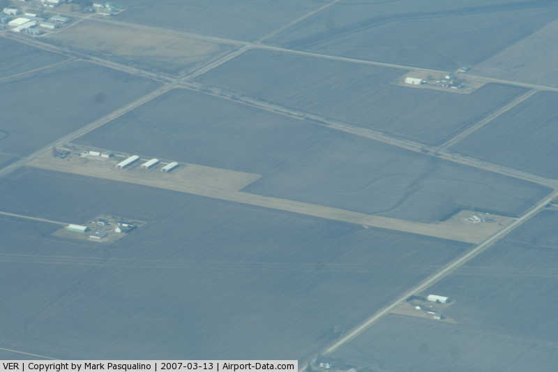
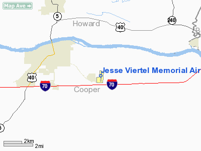
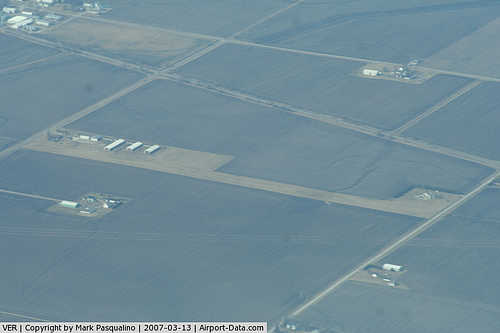
Jesse Viertel Memorial Airport (ICAO: KVER, FAA LID: VER), also known as Jesse P. Viertel Airport, is a city-owned public-use airport located three miles (5 km) southeast of the central business district of Boonville, a city in Cooper County, Missouri, United States. It is home to the Daniel Boone Flying Club, which serves central Missouri.
Although most U.S. airports use the same three-letter location identifier for the FAA and IATA, Jesse Viertel Memorial Airport is assigned VER by the FAA but has no designation from the IATA (which assigned VER to General Heriberto Jara International Airport in Veracruz, Mexico).
Facilities and aircraft
Jesse Viertel Memorial Airport covers an area of 125 acres (51 ha) which contains one runway designated 18/36 with a 3,999 x 75 ft (1,219 x 23 m) asphalt pavement. For the 12-month period ending May 31, 2006, the airport had 9,080 aircraft operations, an average of 24 per day: 92% general aviation (8,380), 4% air taxi (400), 3% military (300).
The above content comes from Wikipedia and is published under free licenses – click here to read more.
|
 |
(Click on the photo to enlarge) |
Location & QuickFacts
| FAA Information Effective: | 2008-09-25 |
| Airport Identifier: | VER |
| Airport Status: | Operational |
| Longitude/Latitude: | 092-40-57.6000W/38-56-48.2000N
-92.682667/38.946722 (Estimated) |
| Elevation: | 715 ft / 217.93 m (Surveyed) |
| Land: | 125 acres |
| From nearest city: | 3 nautical miles SE of Boonville, MO |
| Location: | Cooper County, MO |
| Magnetic Variation: | 02E (2000) |
Owner & Manager
| Ownership: | Publicly owned |
| Owner: | City Of Boonville |
| Address: | 525 E Spring St
Boonville, MO 65233 |
| Phone number: | 660-882-2332 |
| Manager: | Dave Bradley |
| Address: | 20044 Pearre Rd
Boonville, MO 65233 |
| Phone number: | 660-882-7441 |
Airport Operations and Facilities
| Airport Use: | Open to public |
| Wind indicator: | Yes |
| Segmented Circle: | Yes |
| Control Tower: | No |
| Lighting Schedule: | DUSK-DAWN
ACTIVATE MIRL RY 18/36; PAPI RYS 18 & 36; REIL RY 18 & 36 - CTAF. |
| Beacon Color: | Clear-Green (lighted land airport) |
| Landing fee charge: | No |
| Sectional chart: | Kansas City |
| Region: | ACE - Central |
| Boundary ARTCC: | ZKC - Kansas City |
| Tie-in FSS: | COU - Columbia |
| FSS on Airport: | No |
| FSS Toll Free: | 1-800-WX-BRIEF |
| NOTAMs Facility: | COU (NOTAM-d service avaliable) |
| Federal Agreements: | NGY |
Airport Communications
| CTAF: | 122.700 |
| Unicom: | 122.700 |
Airport Services
| Fuel available: | 100LLA MOGAS
SELF SERVICE FUEL AFTER 2000. |
| Airframe Repair: | MAJOR |
| Power Plant Repair: | MAJOR |
| Bottled Oxygen: | NONE |
| Bulk Oxygen: | NONE |
Runway Information
Runway 18/36
| Dimension: | 3999 x 75 ft / 1218.9 x 22.9 m |
| Surface: | ASPH, Good Condition |
| Weight Limit: | Single wheel: 12500 lbs. |
| Edge Lights: | Medium |
| |
Runway 18 |
Runway 36 |
| Longitude: | 092-40-55.5522W | 092-40-59.6694W |
| Latitude: | 38-57-07.9197N | 38-56-28.5253N |
| Elevation: | 709.00 ft | 712.00 ft |
| Alignment: | 127 | 5 |
| Traffic Pattern: | Left | Left |
| Markings: | Non-precision instrument, Good Condition
MARKINGS FADED. | Non-precision instrument, Good Condition
MARKINGS FADED. |
| Crossing Height: | 27.00 ft | 40.00 ft |
| VASI: | 4-light PAPI on left side | 4-light PAPI on left side |
| Visual Glide Angle: | 3.00° | 3.00° |
| Runway End Identifier: | Yes | Yes |
| Obstruction: | 36 ft tree, 750.0 ft from runway, 300 ft right of centerline, 15:1 slope to clear | 16 ft tree, 490.0 ft from runway, 132 ft left of centerline, 18:1 slope to clear |
|
Radio Navigation Aids
| ID |
Type |
Name |
Ch |
Freq |
Var |
Dist |
| VER | NDB | Viertel | | 347.00 | 02E | 0.2 nm |
| PUR | NDB | Marshall | | 371.00 | 03E | 24.6 nm |
| DMO | NDB | Sedalia | | 281.00 | 03E | 27.3 nm |
| ONH | NDB | Noah | | 515.00 | 03E | 27.7 nm |
| FTT | NDB | Guthrie | | 317.00 | 03E | 32.3 nm |
| JE | NDB | Algoa | | 397.00 | 03E | 37.3 nm |
| HCK | NDB | Hawks | | 296.00 | 04E | 45.9 nm |
| SZL | TACAN | Whiteman | 035X | | 04E | 42.6 nm |
| COU | VOR/DME | Columbia | 039X | 110.20 | 03E | 23.2 nm |
| MCM | VOR/DME | Macon | 076X | 112.90 | 06E | 43.5 nm |
| HLV | VORTAC | Hallsville | 089X | 114.20 | 06E | 27.8 nm |
| JEF | VOT | Jefferson City | | 112.00 | | 33.0 nm |
Remarks
- EXTSV STUDENT PILOT TRNG IN VCNTY OF ARPT.
- NOISE ABATEMENT: FOR RY 36 FLY RY CNTRLN TO 1,500 FT BEFORE TURNING ON CRS.
- PAEW ADJ RY 18/36 MOWING.
- PROVIDED AIRCRAFT IN THE TIE-DOWN AREA ARE PARKED WITH THE TAILS TOWARD THE WEST TO AVOID PENETRATION OF THE TRANSITIONAL SURFACE.
Images and information placed above are from
http://www.airport-data.com/airport/VER/
We thank them for the data!
| General Info
|
| Country |
United States
|
| State |
MISSOURI
|
| FAA ID |
VER
|
| Latitude |
38-56-48.234N
|
| Longitude |
092-40-57.618W
|
| Elevation |
715 feet
|
| Near City |
BOONVILLE
|
We don't guarantee the information is fresh and accurate. The data may
be wrong or outdated.
For more up-to-date information please refer to other sources.
|
|