|
|
Jefferson City Memorial Airport |
| Jefferson City Memorial Airport |
 |
| IATA: JEF – ICAO: KJEF – FAA LID: JEF |
| Summary |
| Airport type |
Public |
| Owner |
City of Jefferson City |
| Location |
Jefferson City, Missouri |
| Elevation AMSL |
549 ft / 167 m |
| Coordinates |
38°35′28″N 092°09′22″W / 38.59111°N 92.15611°W / 38.59111; -92.15611 |
| Website |
www.jeffcitymo.org/cd/airport/airport.html |
| Runways |
| Direction |
Length |
Surface |
| ft |
m |
| 12/30 |
6,001 |
1,829 |
Asphalt |
| 9/27 |
3,401 |
1,037 |
Concrete |
| Statistics (2004) |
| Aircraft operations |
34,402 |
| Based aircraft |
67 |
| Source: Federal Aviation Administration |
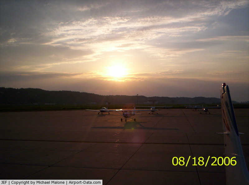
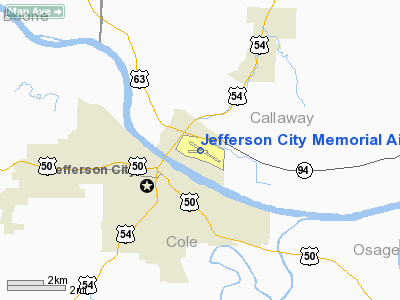
Airport with state capitol in background Jefferson City Memorial Airport (IATA: JEF, ICAO: KJEF, FAA LID: JEF) is a public airport located two miles (3 km) northeast of the central business district of Jefferson City, in Callaway County, Missouri, United States. It is owned by the City of Jefferson City.
Facilities and aircraft
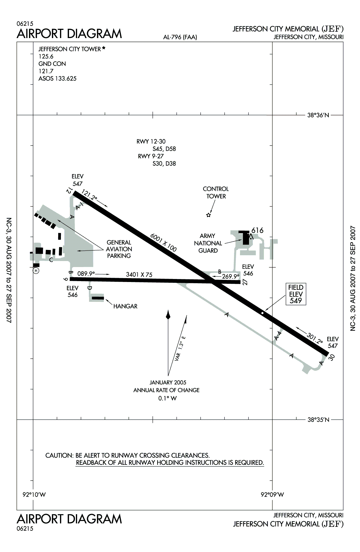
Jefferson City Memorial Airport covers an area of 469 acres (190 ha) which contains two paved runways: 12/30 measuring 6,001 x 100 ft (1,829 x 30 m) and 9/27 measuring 3,401 x 75 ft (1,037 x 23 m).
For the 12-month period ending June 30, 2004, the airport had 34,402 aircraft operations, an average of 94 per day: 83% general aviation, 15% military and 2% air taxi. There are 67 aircraft based at this airport: 48% single engine, 22% multi-engine, 7% jet aircraft, 9% helicopters and 13% military.
The above content comes from Wikipedia and is published under free licenses – click here to read more.
|
 |
(Click on the photo to enlarge) |
Location & QuickFacts
| FAA Information Effective: | 2008-09-25 |
| Airport Identifier: | JEF |
| Airport Status: | Operational |
| Longitude/Latitude: | 092-09-22.1180W/38-35-28.2450N
-92.156144/38.591179 (Estimated) |
| Elevation: | 549 ft / 167.34 m (Surveyed) |
| Land: | 469 acres |
| From nearest city: | 2 nautical miles NE of Jefferson City, MO |
| Location: | Callaway County, MO |
| Magnetic Variation: | 03E (1985) |
Owner & Manager
| Ownership: | Publicly owned |
| Owner: | City Of Jefferson City |
| Address: | 500 Arpt Rd
Jefferson City, MO 65101 |
| Phone number: | 573-634-6469 |
| Manager: | Ron Craft
PATRICK E. SULLIVAN, DIRECTOR OF COMMUNITY DEVELOPMENT, (573) 634-6410 |
| Address: | 500 Arpt Rd
Jefferson City, MO 65101 |
| Phone number: | 573-634-6469 |
Airport Operations and Facilities
| Airport Use: | Open to public |
| Wind indicator: | Yes |
| Segmented Circle: | No |
| Control Tower: | Yes |
| Lighting Schedule: | DUSK-DAWN
WHEN ATCT CLSD ACTVT HIRL RY 12/30; VASI RYS 12 & 30; MALSR RY 30 & TWY 'A' LGTS - CTAF. REIL RY 12 UNAVBL WHEN ATCT CLSD. |
| Beacon Color: | Clear-Green (lighted land airport) |
| Landing fee charge: | No |
| Sectional chart: | Kansas City |
| Region: | ACE - Central |
| Boundary ARTCC: | ZKC - Kansas City |
| Tie-in FSS: | COU - Columbia |
| FSS on Airport: | No |
| FSS Toll Free: | 1-800-WX-BRIEF |
| NOTAMs Facility: | JEF (NOTAM-d service avaliable) |
| Federal Agreements: | NGY |
Airport Communications
| CTAF: | 125.600 |
| Unicom: | 122.950 |
Airport Services
| Fuel available: | 100LLA |
| Airframe Repair: | MAJOR |
| Power Plant Repair: | MAJOR |
| Bottled Oxygen: | NONE |
| Bulk Oxygen: | NONE |
Runway Information
Runway 09/27
| Dimension: | 3401 x 75 ft / 1036.6 x 22.9 m |
| Surface: | CONC, Good Condition |
| Weight Limit: | Single wheel: 30000 lbs.
Dual wheel: 38000 lbs. |
| Edge Lights: | Medium |
| |
Runway 09 |
Runway 27 |
| Longitude: | 092-09-50.8336W | 092-09-08.0041W |
| Latitude: | 38-35-27.7000N | 38-35-27.0573N |
| Elevation: | 546.00 ft | 546.00 ft |
| Alignment: | 91 | 127 |
| Traffic Pattern: | Left | Left |
| Markings: | Basic, Good Condition | Basic, Good Condition |
| Crossing Height: | 25.00 ft | 43.00 ft |
| VASI: | 4-light PAPI on left side | 4-light PAPI on left side |
| Visual Glide Angle: | 3.00° | 3.00° |
| Runway End Identifier: | Yes | Yes
REIL OTS INDEFLY. |
| Obstruction: | 69 ft tree, 2015.0 ft from runway, 159 ft right of centerline, 26:1 slope to clear | 26 ft tree, 1148.0 ft from runway, 20 ft right of centerline, 36:1 slope to clear |
|
Runway 12/30
| Dimension: | 6001 x 100 ft / 1829.1 x 30.5 m |
| Surface: | ASPH, Good Condition |
| Weight Limit: | Single wheel: 45000 lbs.
Dual wheel: 58000 lbs. |
| Edge Lights: | High |
| |
Runway 12 |
Runway 30 |
| Longitude: | 092-09-49.8426W | 092-08-46.1183W |
| Latitude: | 38-35-44.6490N | 38-35-12.7565N |
| Elevation: | 547.00 ft | 547.00 ft |
| Alignment: | 123 | 127 |
| ILS Type: | | ILS/DME
|
| Traffic Pattern: | Left | Left |
| Markings: | Precision instrument, Good Condition | Precision instrument, Good Condition |
| Crossing Height: | 55.00 ft | 50.00 ft |
| VASI: | 4-box on left side | 4-box on left side |
| Visual Glide Angle: | 3.50° | 3.00° |
| Approach lights: | | MALSR |
| Runway End Identifier: | Yes | |
| Obstruction: | 82 ft tree, 2167.0 ft from runway, 382 ft right of centerline, 23:1 slope to clear | , 50:1 slope to clear |
|
Radio Navigation Aids
| ID |
Type |
Name |
Ch |
Freq |
Var |
Dist |
| JE | NDB | Algoa | | 397.00 | 03E | 4.7 nm |
| ONH | NDB | Noah | | 515.00 | 03E | 5.0 nm |
| FTT | NDB | Guthrie | | 317.00 | 03E | 16.7 nm |
| VER | NDB | Viertel | | 347.00 | 02E | 32.8 nm |
| AIZ | NDB | Kaiser | | 377.00 | 05E | 35.1 nm |
| UBX | NDB | Cuba | | 380.00 | 01E | 46.7 nm |
| DMO | NDB | Sedalia | | 281.00 | 03E | 48.4 nm |
| COU | VOR/DME | Columbia | 039X | 110.20 | 03E | 13.5 nm |
| VIH | VOR/DME | Vichy | 124X | 117.70 | 06E | 33.7 nm |
| SHY | VOR/DME | Sunshine | 021X | 108.40 | 05E | 39.2 nm |
| HLV | VORTAC | Hallsville | 089X | 114.20 | 06E | 31.4 nm |
| JEF | VOT | Jefferson City | | 112.00 | | 0.4 nm |
Remarks
- LIGHT TO MODERATE BIRD ACTVTY INVOF ARPT.
- ENTRANCES TO E & S HANGARS, NOT VISIBLE BY TWR.
- FUEL: J8 MIL 1230-2400Z++MON-FRI, 24 HR PN, C573-526-9786, 100LL, A (JEFFERSON CITY FLYING SERVICE, C573-636-5118 24 HR PN).
- TWY 'A1/A2' CONNECTORS OPEN.
- E111 PRVDD APCH TO EACH RWY IS MAINTD FOR A MIN 20:1 GLIDE SLOPE & THE TRANSITIONAL SFC MAINTD FOR A 7:1 SLOPE.
Images and information placed above are from
http://www.airport-data.com/airport/JEF/
We thank them for the data!
| General Info
|
| Country |
United States
|
| State |
MISSOURI
|
| FAA ID |
JEF
|
| Latitude |
38-35-28.245N
|
| Longitude |
092-09-22.118W
|
| Elevation |
549 feet
|
| Near City |
JEFFERSON CITY
|
We don't guarantee the information is fresh and accurate. The data may
be wrong or outdated.
For more up-to-date information please refer to other sources.
|
|