 |
|
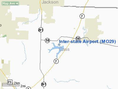
Location & QuickFacts
| FAA Information Effective: | 2008-09-25 |
| Airport Identifier: | MO29 |
| Airport Status: | Operational |
| Longitude/Latitude: | 094-20-05.8130W/38-46-20.0330N
-94.334948/38.772231 (Estimated) |
| Elevation: | 960 ft / 292.61 m (Estimated) |
| Land: | 7 acres |
| From nearest city: | 3 nautical miles W of Pleasant Hill, MO |
| Location: | Cass County, MO |
| Magnetic Variation: | 05E (1985) |
Owner & Manager
| Ownership: | Privately owned |
| Owner: | Rhan Walker |
| Address: | 22207 E 189th Street
Pleasant Hill, MO 64080 |
| Phone number: | 816-540-2888 |
| Manager: | Rhan Walker |
| Address: | 22207 E 189th Street
Pleasant Hill, MO 64080 |
| Phone number: | 816-540-2888 |
Airport Operations and Facilities
| Airport Use: | Private |
| Wind indicator: | Yes |
| Segmented Circle: | No |
| Control Tower: | No |
| Landing fee charge: | No |
| Sectional chart: | Kansas City |
| Region: | ACE - Central |
| Boundary ARTCC: | ZKC - Kansas City |
| Tie-in FSS: | COU - Columbia |
| FSS on Airport: | No |
| FSS Toll Free: | 1-800-WX-BRIEF |
Airport Services
| Fuel available: | 100LL |
| Airframe Repair: | MINOR |
| Power Plant Repair: | MINOR |
Runway Information
Runway N/S
| Dimension: | 2035 x 40 ft / 620.3 x 12.2 m |
| Surface: | GRAVEL, |
| |
Runway N |
Runway S |
| Traffic Pattern: | Left | Left |
| Displaced threshold: | 45.00 ft | 0.00 ft |
| Obstruction: | | 15 ft road, 0.0 ft from runway |
|
Radio Navigation Aids
| ID |
Type |
Name |
Ch |
Freq |
Var |
Dist |
| LXT | NDB | Lesumit | | 263.00 | 04E | 11.5 nm |
| GQ | NDB | Norge | | 517.00 | 05E | 23.0 nm |
| GKB | NDB | Norge | | 517.00 | 05E | 23.0 nm |
| DO | NDB | Dotte | | 359.00 | 05E | 33.2 nm |
| GPH | NDB | Mosby | | 284.00 | 03E | 34.5 nm |
| HCK | NDB | Hawks | | 296.00 | 04E | 36.8 nm |
| GLY | NDB | Golden Valley | | 388.00 | 04E | 39.4 nm |
| SZL | TACAN | Whiteman | 035X | | 04E | 36.8 nm |
| OJC | VOR/DME | Johnson County | 077X | 113.00 | 06E | 19.3 nm |
| RIS | VOR/DME | Riverside | 051X | 111.40 | 05E | 24.2 nm |
| ANX | VORTAC | Napoleon | 087X | 114.00 | 07E | 21.7 nm |
| BUM | VORTAC | Butler | 106X | 115.90 | 07E | 30.9 nm |
| MCI | VORTAC | Kansas City | 079Y | 113.25 | 05E | 36.1 nm |
| MKC | VOT | Kansas City Downtown | | 108.60 | | 24.4 nm |
Remarks
- EACH APCH IS MAINT FOR MIN 20:1 GLIDE SLOPE & TRSNL SFC MAINT FOR 7:1 SLOPE.
Images and information placed above are from
http://www.airport-data.com/airport/MO29/
We thank them for the data!
| General Info
|
| Country |
United States
|
| State |
MISSOURI
|
| FAA ID |
MO29
|
| Latitude |
38-46-20.033N
|
| Longitude |
094-20-05.813W
|
| Elevation |
960 feet
|
| Near City |
PLEASANT HILL
|
We don't guarantee the information is fresh and accurate. The data may
be wrong or outdated.
For more up-to-date information please refer to other sources.
|
|


