 |
|
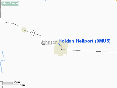
Location & QuickFacts
| FAA Information Effective: | 2008-09-25 |
| Airport Identifier: | 0MU5 |
| Airport Status: | Operational |
| Longitude/Latitude: | 093-59-39.7890W/38-43-11.0390N
-93.994386/38.719733 (Estimated) |
| Elevation: | 865 ft / 263.65 m (Estimated) |
| Land: | 0 acres |
| From nearest city: | 0 nautical miles N of Holden, MO |
| Location: | Johnson County, MO |
| Magnetic Variation: | 04E (1995) |
Owner & Manager
| Ownership: | Publicly owned |
| Owner: | City Of Holden |
| Address: | 101 W 3rd St
Holden, MO 64040 |
| Phone number: | 816-732-4811 |
| Manager: | Larry Milker |
| Address: | 101 W 3rd St
Holden, MO 64040 |
| Phone number: | 816-732-4811 |
Airport Operations and Facilities
| Airport Use: | Private
MEDICAL USE. |
| Segmented Circle: | No |
| Control Tower: | No |
| Lighting Schedule: | RDO-CTL
ACTVT PERIMETER LGTS - 123.05. |
| Sectional chart: | Kansas City |
| Region: | ACE - Central |
| Boundary ARTCC: | ZKC - Kansas City |
| Tie-in FSS: | COU - Columbia |
| FSS on Airport: | No |
| FSS Toll Free: | 1-800-WX-BRIEF |
Airport Communications
Runway Information
Helipad H1
| Dimension: | 30 x 30 ft / 9.1 x 9.1 m |
| Surface: | CONC, |
| |
Runway H1 |
Runway |
| Traffic Pattern: | Left | Left |
|
Radio Navigation Aids
| ID |
Type |
Name |
Ch |
Freq |
Var |
Dist |
| HCK | NDB | Hawks | | 296.00 | 04E | 20.5 nm |
| LXT | NDB | Lesumit | | 263.00 | 04E | 22.8 nm |
| GLY | NDB | Golden Valley | | 388.00 | 04E | 26.1 nm |
| GKB | NDB | Norge | | 517.00 | 05E | 37.1 nm |
| GQ | NDB | Norge | | 517.00 | 05E | 37.1 nm |
| DMO | NDB | Sedalia | | 281.00 | 03E | 38.4 nm |
| GPH | NDB | Mosby | | 284.00 | 03E | 40.4 nm |
| PUR | NDB | Marshall | | 371.00 | 03E | 42.1 nm |
| DO | NDB | Dotte | | 359.00 | 05E | 46.4 nm |
| SZL | TACAN | Whiteman | 035X | | 04E | 20.8 nm |
| OJC | VOR/DME | Johnson County | 077X | 113.00 | 06E | 35.5 nm |
| RIS | VOR/DME | Riverside | 051X | 111.40 | 05E | 37.1 nm |
| ANX | VORTAC | Napoleon | 087X | 114.00 | 07E | 23.4 nm |
| BUM | VORTAC | Butler | 106X | 115.90 | 07E | 35.5 nm |
| MCI | VORTAC | Kansas City | 079Y | 113.25 | 05E | 48.6 nm |
| MKC | VOT | Kansas City Downtown | | 108.60 | | 37.2 nm |
Remarks
- PRVDD CLEAR APCH/DEP PATHS FOR A 8:1 GLIDE SLOPPE; CLEAR TRANSITIONAL SFC FOR A 2:1 SLOPE; PLINES E MKD; SMALL TREE W & RR TELEGRAPH WIRES N REMOVED & DEBRIS I & AROUND HELIPAD REMOVED PRIOR TO ACTVITATION.
Images and information placed above are from
http://www.airport-data.com/airport/0MU5/
We thank them for the data!
| General Info
|
| Country |
United States
|
| State |
MISSOURI
|
| FAA ID |
0MU5
|
| Latitude |
38-43-11.039N
|
| Longitude |
093-59-39.789W
|
| Elevation |
865 feet
|
| Near City |
HOLDEN
|
We don't guarantee the information is fresh and accurate. The data may
be wrong or outdated.
For more up-to-date information please refer to other sources.
|
|


