 |
|
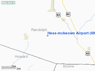
Location & QuickFacts
| FAA Information Effective: | 2008-09-25 |
| Airport Identifier: | 69MO |
| Airport Status: | Operational |
| Longitude/Latitude: | 092-27-14.6470W/39-18-30.1330N
-92.454069/39.308370 (Estimated) |
| Elevation: | 885 ft / 269.75 m (Estimated) |
| Land: | 0 acres |
| From nearest city: | 3 nautical miles E of Higbee, MO |
| Location: | Randolph County, MO |
| Magnetic Variation: | 03E (1985) |
Owner & Manager
| Ownership: | Privately owned |
| Owner: | Raymond L Hess |
| Address: | Rr 2 Box 125
Higbee, MO 65257 |
| Phone number: | 816-456-7421 |
| Manager: | Raymond L Hess |
| Address: | Rr 2 Box 125
Higbee, MO 65257 |
| Phone number: | 816-456-7421 |
Airport Operations and Facilities
| Airport Use: | Private |
| Wind indicator: | Yes |
| Segmented Circle: | No |
| Control Tower: | No |
| Landing fee charge: | No |
| Sectional chart: | Kansas City |
| Region: | ACE - Central |
| Boundary ARTCC: | ZKC - Kansas City |
| Tie-in FSS: | COU - Columbia |
| FSS on Airport: | No |
| FSS Toll Free: | 1-800-WX-BRIEF |
Runway Information
Runway 10/28
| Dimension: | 1800 x 60 ft / 548.6 x 18.3 m |
| Surface: | TURF, |
| |
Runway 10 |
Runway 28 |
| Traffic Pattern: | Left | Left |
| Obstruction: | 25 ft trees, 600.0 ft from runway | , 0.0 ft from runway |
|
Radio Navigation Aids
| ID |
Type |
Name |
Ch |
Freq |
Var |
Dist |
| VER | NDB | Viertel | | 347.00 | 02E | 24.1 nm |
| FTT | NDB | Guthrie | | 317.00 | 03E | 35.0 nm |
| PUR | NDB | Marshall | | 371.00 | 03E | 38.1 nm |
| BZK | NDB | Brookfield | | 383.00 | 03E | 40.9 nm |
| ONH | NDB | Noah | | 515.00 | 03E | 41.5 nm |
| JE | NDB | Algoa | | 397.00 | 03E | 49.1 nm |
| DMO | NDB | Sedalia | | 281.00 | 03E | 49.6 nm |
| MCM | VOR/DME | Macon | 076X | 112.90 | 06E | 20.8 nm |
| COU | VOR/DME | Columbia | 039X | 110.20 | 03E | 31.9 nm |
| HLV | VORTAC | Hallsville | 089X | 114.20 | 06E | 19.2 nm |
| JEF | VOT | Jefferson City | | 112.00 | | 45.5 nm |
Remarks
- OWNER DESIRES CHARTING
- PROVIDED THE APPROACH TO EACH RWY IS MAINTAINED FOR A MINIMUM 20:1 GLIDE SLOPE AND THE TRANSITIONAL SURFACE BE MAINTAINED FOR A 7:1 SLOPE.
Images and information placed above are from
http://www.airport-data.com/airport/69MO/
We thank them for the data!
| General Info
|
| Country |
United States
|
| State |
MISSOURI
|
| FAA ID |
69MO
|
| Latitude |
39-18-30.133N
|
| Longitude |
092-27-14.647W
|
| Elevation |
885 feet
|
| Near City |
HIGBEE
|
We don't guarantee the information is fresh and accurate. The data may
be wrong or outdated.
For more up-to-date information please refer to other sources.
|
|


