 |
|
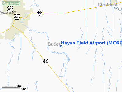
Location & QuickFacts
| FAA Information Effective: | 2008-09-25 |
| Airport Identifier: | MO67 |
| Airport Status: | Operational |
| Longitude/Latitude: | 090-18-50.3830W/36-42-40.2000N
-90.313995/36.711167 (Estimated) |
| Elevation: | 323 ft / 98.45 m (Estimated) |
| Land: | 13 acres |
| From nearest city: | 3 nautical miles SE of Poplar Bluff, MO |
| Location: | Butler County, MO |
| Magnetic Variation: | 02E (1985) |
Owner & Manager
| Ownership: | Privately owned |
| Owner: | Jon E. Hayes |
| Address: | Route 1
Broseley, MO 63932 |
| Phone number: | 573-785-8638 |
| Manager: | J.e. Hayes |
| Address: | P.o. Box 1202
Poplar Bluff, MO 63901 |
| Phone number: | 573-686-3038 |
Airport Operations and Facilities
| Airport Use: | Private |
| Wind indicator: | Yes |
| Segmented Circle: | No |
| Control Tower: | No |
| Landing fee charge: | No |
| Sectional chart: | St Louis |
| Region: | ACE - Central |
| Boundary ARTCC: | ZME - Memphis |
| Tie-in FSS: | STL - Saint Louis |
| FSS on Airport: | No |
| FSS Toll Free: | 1-800-WX-BRIEF |
Airport Services
| Fuel available: | 100LL |
| Airframe Repair: | NONE |
| Power Plant Repair: | NONE |
Runway Information
Runway 12/30
| Dimension: | 2400 x 100 ft / 731.5 x 30.5 m |
| Surface: | TURF, |
| |
Runway 12 |
Runway 30 |
| Traffic Pattern: | Left | Left |
|
Runway 18/36
| Dimension: | 3000 x 100 ft / 914.4 x 30.5 m |
| Surface: | TURF, |
| |
Runway 18 |
Runway 36 |
| Traffic Pattern: | Left | Right |
|
Radio Navigation Aids
| ID |
Type |
Name |
Ch |
Freq |
Var |
Dist |
| FD | NDB | Earli | | 278.00 | 03E | 2.6 nm |
| DXE | NDB | Dexter | | 423.00 | 00E | 18.6 nm |
| TKX | NDB | Kennett | | 358.00 | 00E | 31.9 nm |
| PGR | NDB | Paragould | | 383.00 | 01E | 40.1 nm |
| TNZ | NDB | Lawrence County | | 227.00 | 01E | 42.3 nm |
| CHQ | NDB | Charleston | | 208.00 | 01E | 46.8 nm |
| MXA | NDB | Manila | | 282.00 | 01E | 49.9 nm |
| GOJ | VOR | Gosnell | | 111.80 | 01E | 49.1 nm |
| CGI | VOR/DME | Cape Girardeau | 076X | 112.90 | 01E | 47.2 nm |
| MAW | VORTAC | Malden | 049X | 111.20 | 03E | 21.6 nm |
| ARG | VORTAC | Walnut Ridge | 092X | 114.50 | 04E | 47.6 nm |
Remarks
- EXTENSIVE AGRI FLYING.
- PRVDD A CLEAR APCH TO EACH RY FOR A MINIMUM 20:1 GLIDE SLOPE AND A CLEAR TRANSITIONAL SFC FOR A 7:1 SLOPE.
Images and information placed above are from
http://www.airport-data.com/airport/MO67/
We thank them for the data!
| General Info
|
| Country |
United States
|
| State |
MISSOURI
|
| FAA ID |
MO67
|
| Latitude |
36-42-40.200N
|
| Longitude |
090-18-50.383W
|
| Elevation |
323 feet
|
| Near City |
POPLAR BLUFF
|
We don't guarantee the information is fresh and accurate. The data may
be wrong or outdated.
For more up-to-date information please refer to other sources.
|
|


