|
|
Hannibal Regional Airport |
Hannibal Regional Airport
William P. Lear Field |
| IATA: none – ICAO: KHAE – FAA LID: HAE |
| Summary |
| Airport type |
Public |
| Owner |
City of Hannibal |
| Serves |
Hannibal, Missouri |
| Elevation AMSL |
769 ft / 234 m |
| Coordinates |
39°43′31″N 091°26′38″W / 39.72528°N 91.44389°W / 39.72528; -91.44389 |
| Website |
www.flyhannibal.net |
| Runways |
| Direction |
Length |
Surface |
| ft |
m |
| 17/35 |
4,400 |
1,341 |
Concrete |
| Statistics (2007) |
| Aircraft operations |
4,700 |
| Based aircraft |
20 |
| Source: Federal Aviation Administration |
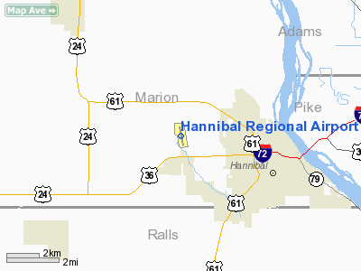
Hannibal Regional Airport (ICAO: KHAE, FAA LID: HAE) is a public use airport in Marion County, Missouri, United States. It is located four nautical miles (7 km) northwest of the central business district of Hannibal, Missouri, and is owned by the City of Hannibal. The airport is used for general aviation with no commercial airlines.
Although most U.S. airports use the same three-letter location identifier for the FAA and IATA, this airport is assigned HAE by the FAA but has no designation from the IATA. History
In 2003, the airport was renamed Hannibal Regional Airport, William P. Lear Field in honor of the inventor of the Lear Jet. It was originally known as Hannibal Municipal Airport.
Facilities and aircraft
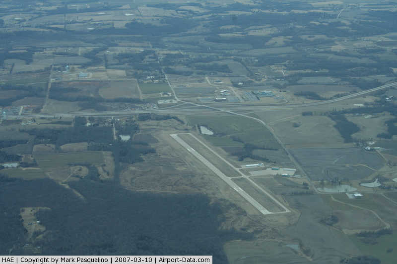
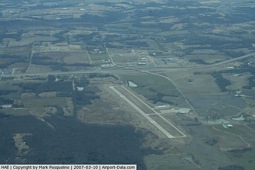
Hannibal Regional Airport covers an area of 400 acres (162 ha) at an elevation of 769 feet (234 m) above mean sea level. It has one runway designated 17/35 with a concrete surface measuring 4,400 by 100 feet (1,341 x 30 m) with a concrete surface. Runway 17/35 has Runway End Identifier Lights (REIL) and Precision Approach Path Indicator (PAPI) lights on each runway end.
The airport originally had an asphalt runway that was 3,600 feet (1,100 m) x 75 feet (23 m) with no parallel taxiway. In 2002 the airport was completely shut down for almost 6 months while the old runway and apron were completely removed and a new concrete runway (4,400 x 100 ft.) was constructed. In addition to the new runway, a concrete full-length parallel taxiway was constructed, the apron was re-constructed with concrete, and a new hangar area was constructed.
Beginning in 2008, the airport's Fixed Based Operator (FBO) is Mike Barron of Barron Aviation Private Flight Services. Prior to that, Rodney Hilton managed the airport.
For the 12-month period ending August 9, 2007, the airport had 4,700 aircraft operations, an average of 12 per day: 79% general aviation and 21% air taxi. At that time there were 20 aircraft based at this airport: 90% single-engine, 5% multi-engine and 5% helicopter.
Future plans
The future plans include extending the runway to 5,000 to allow small jets to use the airport. In addition, a new terminal building is planned for the airport.
The above content comes from Wikipedia and is published under free licenses – click here to read more.
|
 |
(Click on the photo to enlarge) |
Location & QuickFacts
| FAA Information Effective: | 2008-09-25 |
| Airport Identifier: | HAE |
| Airport Status: | Operational |
| Longitude/Latitude: | 091-26-37.9000W/39-43-30.6000N
-91.443861/39.725167 (Estimated) |
| Elevation: | 769 ft / 234.39 m (Surveyed) |
| Land: | 400 acres |
| From nearest city: | 4 nautical miles NW of Hannibal, MO |
| Location: | Marion County, MO |
| Magnetic Variation: | 03E (1985) |
Owner & Manager
| Ownership: | Publicly owned |
| Owner: | City Of Hannibal |
| Address: | City Hall - 320 Broadway
Hannibal, MO 63401 |
| Phone number: | 573-221-0111 |
| Manager: | Jamie Page
APRT ATTENDED BY FBO MGR RODNEY HILTEN, 573-221-3230. |
| Address: | 320 Broadway
Hannibal, MO 63401 |
| Phone number: | 573-221-0111 |
Airport Operations and Facilities
| Airport Use: | Open to public |
| Wind indicator: | Yes |
| Segmented Circle: | Yes |
| Control Tower: | No |
| Lighting Schedule: | DUSK-DAWN
ACTVT MIRL RY 17/35, REIL RWY 17/35, PAPI RWY 17/35 - CTAF. |
| Beacon Color: | Clear-Green (lighted land airport) |
| Landing fee charge: | No |
| Sectional chart: | Kansas City |
| Region: | ACE - Central |
| Boundary ARTCC: | ZKC - Kansas City |
| Tie-in FSS: | STL - Saint Louis |
| FSS on Airport: | No |
| FSS Toll Free: | 1-800-WX-BRIEF |
| NOTAMs Facility: | STL (NOTAM-d service avaliable) |
| Federal Agreements: | NGY |
Airport Communications
| CTAF: | 122.800 |
| Unicom: | 122.800 |
Airport Services
| Fuel available: | 100LLA |
| Airframe Repair: | MAJOR |
| Power Plant Repair: | MAJOR |
| Bottled Oxygen: | NONE |
| Bulk Oxygen: | NONE |
Runway Information
Runway 17/35
| Dimension: | 4400 x 100 ft / 1341.1 x 30.5 m |
| Surface: | CONC, Good Condition |
| Weight Limit: | Single wheel: 12000 lbs. |
| Edge Lights: | Medium |
| |
Runway 17 |
Runway 35 |
| Longitude: | 091-26-42.8607W | 091-26-32.8646W |
| Latitude: | 39-43-51.9845N | 39-43-09.1904N |
| Elevation: | 758.00 ft | 768.00 ft |
| Alignment: | 127 | 127 |
| Traffic Pattern: | Left | Left |
| Markings: | Non-precision instrument, Good Condition | Non-precision instrument, Good Condition |
| Crossing Height: | 40.00 ft | 40.00 ft |
| VASI: | 4-light PAPI on left side | 4-light PAPI on left side |
| Visual Glide Angle: | 3.00° | 3.00° |
| Runway End Identifier: | Yes | Yes |
| Obstruction: | 57 ft trees, 1908.0 ft from runway, 66 ft left of centerline, 29:1 slope to clear | 45 ft trees, 1298.0 ft from runway, 323 ft left of centerline, 24:1 slope to clear |
|
Radio Navigation Aids
| ID |
Type |
Name |
Ch |
Freq |
Var |
Dist |
| HAE | NDB | Hannibal | | 411.00 | 03E | 0.2 nm |
| UI | NDB | Quincy | | 293.00 | 02E | 13.1 nm |
| PPQ | NDB | Pittsfield | | 344.00 | 02E | 31.0 nm |
| EOK | NDB | Keokuk | | 366.00 | 02E | 44.5 nm |
| MCM | VOR/DME | Macon | 076X | 112.90 | 06E | 48.2 nm |
| UIN | VORTAC | Quincy | 083X | 113.60 | 05E | 10.6 nm |
| HLV | VORTAC | Hallsville | 089X | 114.20 | 06E | 48.6 nm |
Remarks
- MAINTAIN CLEAR OF HOSPITAL AREA WHEN DEPARTING RWY 17.
Images and information placed above are from
http://www.airport-data.com/airport/HAE/
We thank them for the data!
| General Info
|
| Country |
United States
|
| State |
MISSOURI
|
| FAA ID |
HAE
|
| Latitude |
39-43-28.162N
|
| Longitude |
091-26-37.246W
|
| Elevation |
772 feet
|
| Near City |
HANNIBAL
|
We don't guarantee the information is fresh and accurate. The data may
be wrong or outdated.
For more up-to-date information please refer to other sources.
|
|