 |
|
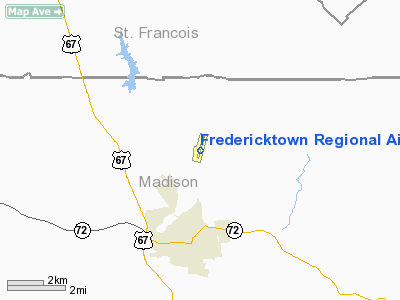
Fredericktown Regional Airport |
Location & QuickFacts
| FAA Information Effective: | 2008-09-25 |
| Airport Identifier: | H88 |
| Airport Status: | Operational |
| Longitude/Latitude: | 090-17-14.3300W/37-36-20.9700N
-90.287314/37.605825 (Estimated) |
| Elevation: | 880 ft / 268.22 m (Estimated) |
| Land: | 83 acres |
| From nearest city: | 3 nautical miles N of Fredericktown, MO |
| Location: | Madison County, MO |
| Magnetic Variation: | 00E (2000) |
Owner & Manager
| Ownership: | Publicly owned |
| Owner: | City Of Fredericktown |
| Address: | 124 W Main St, Po Box 549
Fredricktown, MO 63645 |
| Phone number: | 573-783-3683 |
| Manager: | Tina Varnum |
| Address: | 1935 Oo Hwy, Po Box 549
Fredricktown, MO 63645 |
| Phone number: | 573-783-3319
ARPT PHONE - (573) 783-4040 |
Airport Operations and Facilities
| Airport Use: | Open to public |
| Wind indicator: | Yes |
| Segmented Circle: | No |
| Control Tower: | No |
| Lighting Schedule: | DUSK-DAWN
ACTVT MIRL RY 01/19 & PAPI RYS 01 & 19 - CTAF. |
| Beacon Color: | Clear-Green (lighted land airport) |
| Landing fee charge: | No |
| Sectional chart: | St Louis |
| Region: | ACE - Central |
| Boundary ARTCC: | ZKC - Kansas City |
| Tie-in FSS: | STL - Saint Louis |
| FSS on Airport: | No |
| FSS Toll Free: | 1-800-WX-BRIEF |
| NOTAMs Facility: | STL (NOTAM-d service avaliable) |
| Federal Agreements: | N |
Airport Communications
| CTAF: | 122.800 |
| Unicom: | 122.800 |
Airport Services
| Fuel available: | 100LLA MOGAS |
| Airframe Repair: | MAJOR |
| Power Plant Repair: | MINOR |
Runway Information
Runway 01/19
| Dimension: | 4000 x 75 ft / 1219.2 x 22.9 m |
| Surface: | ASPH, Good Condition |
| Weight Limit: | Single wheel: 12500 lbs. |
| Edge Lights: | Medium |
| |
Runway 01 |
Runway 19 |
| Longitude: | 090-17-20.5600W | 090-17-08.0900W |
| Latitude: | 37-36-01.8300N | 37-36-40.1100N |
| Elevation: | 875.00 ft | 875.00 ft |
| Alignment: | 15 | 127 |
| Traffic Pattern: | Left | Left |
| Markings: | Non-precision instrument, Good Condition | Non-precision instrument, Good Condition |
| Crossing Height: | 40.00 ft | 42.00 ft |
| VASI: | 4-light PAPI on left side | 4-light PAPI on left side |
| Visual Glide Angle: | 3.00° | 3.00° |
| Obstruction: | , 50:1 slope to clear | 38 ft trees, 754.0 ft from runway, 174 ft right of centerline, 14:1 slope to clear |
|
Radio Navigation Aids
| ID |
Type |
Name |
Ch |
Freq |
Var |
Dist |
| PRI | NDB | Perrine | | 367.00 | 02E | 11.7 nm |
| FES | NDB | Festus | | 269.00 | 01E | 35.8 nm |
| SAR | NDB | Sparta | | 239.00 | 01E | 42.7 nm |
| PJY | NDB | Pinckneyville | | 215.00 | 00E | 49.2 nm |
| CGI | VOR/DME | Cape Girardeau | 076X | 112.90 | 01E | 41.0 nm |
| FAM | VORTAC | Farmington | 104X | 115.70 | 01E | 4.8 nm |
Remarks
- WILDLIFE ON & INVOF ARPT.
Images and information placed above are from
http://www.airport-data.com/airport/H88/
We thank them for the data!
| General Info
|
| Country |
United States
|
| State |
MISSOURI
|
| FAA ID |
H88
|
| Latitude |
37-36-20.970N
|
| Longitude |
090-17-14.330W
|
| Elevation |
880 feet
|
| Near City |
FREDERICKTOWN
|
We don't guarantee the information is fresh and accurate. The data may
be wrong or outdated.
For more up-to-date information please refer to other sources.
|
|


