 |
|
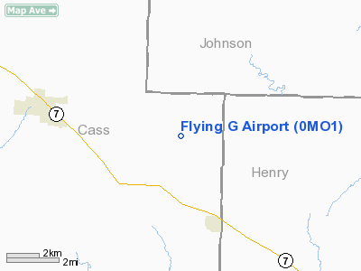
Location & QuickFacts
| FAA Information Effective: | 2008-09-25 |
| Airport Identifier: | 0MO1 |
| Airport Status: | Operational |
| Longitude/Latitude: | 094-05-40.7930W/38-32-40.0510N
-94.094665/38.544459 (Estimated) |
| Elevation: | 920 ft / 280.42 m (Estimated) |
| Land: | 0 acres |
| From nearest city: | 3 nautical miles NW of Creighton, MO |
| Location: | Cass County, MO |
| Magnetic Variation: | 05E (1985) |
Owner & Manager
| Ownership: | Privately owned |
| Owner: | Frank Gregg |
| Address: |
Creighton, MO 64739 |
| Phone number: | 816-499-2490 |
| Manager: | Frank Gregg |
| Address: |
Creighton, MO 64739 |
| Phone number: | 816-499-2490 |
Airport Operations and Facilities
| Airport Use: | Private |
| Wind indicator: | No |
| Segmented Circle: | No |
| Control Tower: | No |
| Landing fee charge: | No |
| Sectional chart: | Kansas City |
| Region: | ACE - Central |
| Boundary ARTCC: | ZKC - Kansas City |
| Tie-in FSS: | COU - Columbia |
| FSS on Airport: | No |
| FSS Toll Free: | 1-800-WX-BRIEF |
Runway Information
Runway 08/26
| Dimension: | 2100 x 50 ft / 640.1 x 15.2 m |
| Surface: | TURF, |
| |
Runway 08 |
Runway 26 |
| Traffic Pattern: | Left | Left |
|
Radio Navigation Aids
| ID |
Type |
Name |
Ch |
Freq |
Var |
Dist |
| GLY | NDB | Golden Valley | | 388.00 | 04E | 22.3 nm |
| HCK | NDB | Hawks | | 296.00 | 04E | 25.1 nm |
| LXT | NDB | Lesumit | | 263.00 | 04E | 28.2 nm |
| GKB | NDB | Norge | | 517.00 | 05E | 40.7 nm |
| GQ | NDB | Norge | | 517.00 | 05E | 40.7 nm |
| EAD | NDB | Nevada | | 209.00 | 06E | 42.4 nm |
| DMO | NDB | Sedalia | | 281.00 | 03E | 44.2 nm |
| GPH | NDB | Mosby | | 284.00 | 03E | 49.2 nm |
| SZL | TACAN | Whiteman | 035X | | 04E | 28.0 nm |
| OJC | VOR/DME | Johnson County | 077X | 113.00 | 06E | 35.0 nm |
| RIS | VOR/DME | Riverside | 051X | 111.40 | 05E | 41.8 nm |
| BUM | VORTAC | Butler | 106X | 115.90 | 07E | 24.7 nm |
| ANX | VORTAC | Napoleon | 087X | 114.00 | 07E | 33.2 nm |
| MKC | VOT | Kansas City Downtown | | 108.60 | | 42.0 nm |
Remarks
- PROVIDED RWY THR IS DSPLCD SUFFICIENT DISTANCE SO ROAD NO LONGER PRESENTS UNSAFE COND; PVT USE.
Images and information placed above are from
http://www.airport-data.com/airport/0MO1/
We thank them for the data!
| General Info
|
| Country |
United States
|
| State |
MISSOURI
|
| FAA ID |
0MO1
|
| Latitude |
38-32-40.051N
|
| Longitude |
094-05-40.793W
|
| Elevation |
920 feet
|
| Near City |
CREIGHTON
|
We don't guarantee the information is fresh and accurate. The data may
be wrong or outdated.
For more up-to-date information please refer to other sources.
|
|


