 |
|
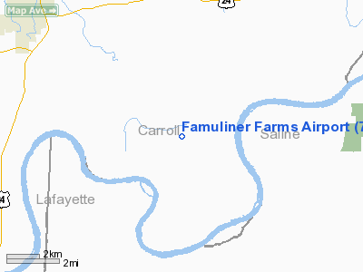
Location & QuickFacts
| FAA Information Effective: | 2008-09-25 |
| Airport Identifier: | 71MO |
| Airport Status: | Operational |
| Longitude/Latitude: | 093-23-02.7510W/39-17-31.0770N
-93.384097/39.291966 (Estimated) |
| Elevation: | 655 ft / 199.64 m (Estimated) |
| Land: | 6 acres |
| From nearest city: | 1 nautical miles NW of Wakenda, MO |
| Location: | Carroll County, MO |
| Magnetic Variation: | 04E (1985) |
Owner & Manager
| Ownership: | Privately owned |
| Owner: | Jim & Dennis Famuliner |
| Address: | Route 5, Box 67
Carrollton, MO 64633 |
| Phone number: | 816-542-2019 |
| Manager: | Jim Famuliner |
| Address: | Route 5, Box 67
Carrollton, MO 64633 |
| Phone number: | 816-542-2019 |
Airport Operations and Facilities
| Airport Use: | Private |
| Wind indicator: | Yes |
| Segmented Circle: | No |
| Control Tower: | No |
| Landing fee charge: | No |
| Sectional chart: | Kansas City |
| Region: | ACE - Central |
| Boundary ARTCC: | ZKC - Kansas City |
| Tie-in FSS: | COU - Columbia |
| FSS on Airport: | No |
| FSS Toll Free: | 1-800-WX-BRIEF |
Runway Information
Runway 17/35
| Dimension: | 3000 x 80 ft / 914.4 x 24.4 m |
| Surface: | TURF, |
| |
Runway 17 |
Runway 35 |
| Traffic Pattern: | Left | Left |
| Obstruction: | | 50 ft bldg, 0.0 ft from runway |
|
Radio Navigation Aids
| ID |
Type |
Name |
Ch |
Freq |
Var |
Dist |
| PUR | NDB | Marshall | | 371.00 | 03E | 17.4 nm |
| CHT | NDB | Chillicothe | | 375.00 | 03E | 29.6 nm |
| BZK | NDB | Brookfield | | 383.00 | 03E | 31.1 nm |
| DMO | NDB | Sedalia | | 281.00 | 03E | 36.6 nm |
| VER | NDB | Viertel | | 347.00 | 02E | 38.6 nm |
| HCK | NDB | Hawks | | 296.00 | 04E | 40.8 nm |
| GPH | NDB | Mosby | | 284.00 | 03E | 43.1 nm |
| TRX | NDB | Trenton | | 400.00 | 03E | 48.4 nm |
| EZZ | NDB | Cameron | | 394.00 | 03E | 48.9 nm |
| SZL | TACAN | Whiteman | 035X | | 04E | 34.3 nm |
| BQS | VOR/DME | Braymer | 049X | 111.20 | 03E | 30.6 nm |
| MCM | VOR/DME | Macon | 076X | 112.90 | 06E | 47.2 nm |
| ANX | VORTAC | Napoleon | 087X | 114.00 | 07E | 36.6 nm |
Remarks
- PROVIDED APPROACH TO EACH RWY IS MAINTAINED FOR A MINIMUM 20:1 GLIDE SLOPE AND THE TRANSITIONAL SURFACE BE MAINTAINED FOR A 7:1 SLOPE.
Images and information placed above are from
http://www.airport-data.com/airport/71MO/
We thank them for the data!
| General Info
|
| Country |
United States
|
| State |
MISSOURI
|
| FAA ID |
71MO
|
| Latitude |
39-17-31.077N
|
| Longitude |
093-23-02.751W
|
| Elevation |
655 feet
|
| Near City |
WAKENDA
|
We don't guarantee the information is fresh and accurate. The data may
be wrong or outdated.
For more up-to-date information please refer to other sources.
|
|


