 |
|
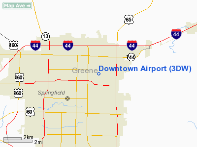
| Downtown Airport |
| IATA: none – ICAO: none – FAA LID: 3DW |
| Summary |
| Airport type |
Public |
| Owner |
Harry Cooper |
| Serves |
Springfield, Missouri |
| Elevation AMSL |
1,374 ft / 419 m |
| Coordinates |
37°13′18″N 093°14′52″W / 37.22167°N 93.24778°W / 37.22167; -93.24778 |
| Runways |
| Direction |
Length |
Surface |
| ft |
m |
| 11/29 |
4,035 |
1,230 |
Asphalt |
| Statistics (2005) |
| Aircraft operations |
5,800 |
| Based aircraft |
43 |
| Source: Federal Aviation Administration |
Downtown Airport (FAA LID: 3DW) is a privately-owned, public-use airport located in the city of Springfield in Greene County, Missouri, United States.
Facilities and aircraft
Downtown Airport covers an area of 160 acres (65 ha) and has one runway designated 11/29 with a 4,035 x 50 ft (1,230 x 15 m) asphalt surface. For the 12-month period ending November 30, 2005, the airport had 5,800 aircraft operations, an average of 15 per day: 95% general aviation, 4% air taxi and 1% military. At that time there were 43 aircraft based at this airport: 86% single-engine, 7% multi-engine, 5% jet and 2% helicopter.
The above content comes from Wikipedia and is published under free licenses – click here to read more.
Location & QuickFacts
| FAA Information Effective: | 2008-09-25 |
| Airport Identifier: | 3DW |
| Airport Status: | Operational |
| Longitude/Latitude: | 093-14-51.6700W/37-13-18.1710N
-93.247686/37.221714 (Estimated) |
| Elevation: | 1374 ft / 418.80 m (Estimated) |
| Land: | 160 acres |
| From nearest city: | 0 nautical miles E of Springfield, MO |
| Location: | Greene County, MO |
| Magnetic Variation: | 04E (1985) |
Owner & Manager
| Ownership: | Privately owned |
| Owner: | Harry Cooper |
| Address: | Rte 2
Springfield, MO 65803 |
| Manager: | Bill Johnmeyer |
| Address: | 2546 E Division St
Springfield, MO 65803 |
| Phone number: | 417-862-2418 |
Airport Operations and Facilities
| Airport Use: | Open to public |
| Wind indicator: | Yes |
| Segmented Circle: | No |
| Control Tower: | No |
| Lighting Schedule: | DUSK-DAWN |
| Landing fee charge: | No |
| Sectional chart: | Kansas City |
| Region: | ACE - Central |
| Boundary ARTCC: | ZKC - Kansas City |
| Tie-in FSS: | COU - Columbia |
| FSS on Airport: | No |
| FSS Toll Free: | 1-800-WX-BRIEF |
| NOTAMs Facility: | COU (NOTAM-d service avaliable) |
Airport Communications
| CTAF: | 122.800 |
| Unicom: | 122.800 |
Airport Services
| Fuel available: | 100LLA |
| Airframe Repair: | MAJOR |
| Power Plant Repair: | MAJOR |
| Bottled Oxygen: | NONE |
| Bulk Oxygen: | NONE |
Runway Information
Runway 11/29
| Dimension: | 4035 x 50 ft / 1229.9 x 15.2 m |
| Surface: | ASPH, Good Condition |
| Weight Limit: | Single wheel: 8000 lbs. |
| Edge Lights: | Non-standard lighting system
NSTD MIRL; 3 THLD LGTS EACH RY, EDGE LGTS SPACED 240 FT APART. |
| |
Runway 11 |
Runway 29 |
| Longitude: | 093-15-17.3400W | 093-14-30.0000W |
| Latitude: | 37-13-27.5900N | 37-13-15.0000N |
| Elevation: | 1352.00 ft | 1374.00 ft |
| Alignment: | 108 | 127 |
| Traffic Pattern: | Left | Left |
| Markings: | Nonstandard, Good Condition
RWY 11 NSTD NPI MARKINGS; SMALL MKGS; INCORRECT SPACING & SMALL DASHED CNTRLN. | Nonstandard, Good Condition
RWY 29 NSTD NPI MARKINGS; SMALL MKGS; INCORRECT SPACING & SMALL DASHED CNTRLN. |
| Obstruction: | 55 ft trees, 845.0 ft from runway, 25 ft left of centerline, 11:1 slope to clear | 88 ft trees, 1460.0 ft from runway, 30 ft left of centerline, 14:1 slope to clear |
|
Radio Navigation Aids
| ID |
Type |
Name |
Ch |
Freq |
Var |
Dist |
| ILJ | NDB | Willard | | 254.00 | 03E | 10.3 nm |
| AOV | NDB | Bilmart | | 341.00 | 02E | 31.3 nm |
| IEB | NDB | Lebanon | | 414.00 | 03E | 35.1 nm |
| PLK | NDB | Point Lookout/dcmsnd | | 204.00 | 03E | 35.7 nm |
| SGF | VORTAC | Springfield | 116X | 116.90 | 04E | 9.1 nm |
| DGD | VORTAC | Dogwood | 031X | 109.40 | 06E | 21.4 nm |
Remarks
- 600 FT LGTD TOWER 950 FT N OF RY 29 THLD.
- USE CAUTION FOR POWERED PARACHUTE ACTVTY INVOF ARPT AT OR BLO 1,000 FT.
- NTSD RY SAFETY AREA BYD RY 29 THLD; LARGE SLOPE.
- PRVDD APCH SLOPES ARE MAINT FOR 20:1 & TRSNL SFC 7:1.
Images and information placed above are from
http://www.airport-data.com/airport/3DW/
We thank them for the data!
| General Info
|
| Country |
United States
|
| State |
MISSOURI
|
| FAA ID |
3DW
|
| Latitude |
37-13-18.171N
|
| Longitude |
093-14-51.670W
|
| Elevation |
1374 feet
|
| Near City |
SPRINGFIELD
|
We don't guarantee the information is fresh and accurate. The data may
be wrong or outdated.
For more up-to-date information please refer to other sources.
|
|


